


Summary
Albert Street is a street in the Brisbane central business district, Queensland, Australia. It was named after Prince Albert, the Prince Consort of Queen Victoria of the United Kingdom.[1] Albert Street railway station is being built directly beneath the street and is expected to open in 2026. The station precinct includes partial road closures as planned in the 2014 City Centre Master Plan, for the creation of a new public space.[2]
Albert Street | |
|---|---|
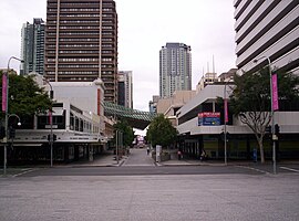 | |
| Albert Street Mall from King George Square. | |
.mw-parser-output .locmap .od{position:absolute}.mw-parser-output .locmap .id{position:absolute;line-height:0}.mw-parser-output .locmap .l0{font-size:0;position:absolute}.mw-parser-output .locmap .pv{line-height:110%;position:absolute;text-align:center}.mw-parser-output .locmap .pl{line-height:110%;position:absolute;top:-0.75em;text-align:right}.mw-parser-output .locmap .pr{line-height:110%;position:absolute;top:-0.75em;text-align:left}.mw-parser-output .locmap .pv>div{display:inline;padding:1px}.mw-parser-output .locmap .pl>div{display:inline;padding:1px;float:right}.mw-parser-output .locmap .pr>div{display:inline;padding:1px;float:left}html.skin-theme-clientpref-night .mw-parser-output .od,html.skin-theme-clientpref-night .mw-parser-output .od .pv>div,html.skin-theme-clientpref-night .mw-parser-output .od .pl>div,html.skin-theme-clientpref-night .mw-parser-output .od .pr>div{background:#000;color:#fff}html.skin-theme-clientpref-night .mw-parser-output .locmap{filter:grayscale(0.6)}@media(prefers-color-scheme:dark){html.skin-theme-clientpref-os .mw-parser-output .locmap{filter:grayscale(0.6)}html.skin-theme-clientpref-os .mw-parser-output .od,html.skin-theme-clientpref-os .mw-parser-output .od .pv>div,html.skin-theme-clientpref-os .mw-parser-output .od .pl>div,html.skin-theme-clientpref-os .mw-parser-output .od .pr>div{background:#000;color:#fff}} Albert Street | |
| Coordinates |
|
| General information | |
| Type | Street |
| Location | Brisbane |
Geography edit
The street forms a key city axis.[3] The southern part of Albert Street is low-lying and prone to flooding; it was part of the historic Frog's Hollow district. The Brisbane City Council has a vision to turn Albert Street into a subtropical boulevard linking the Roma Street Parklands and Wickham Park with the City Botanic Gardens.[2] In the 2014 City Centre Master Plan, Albert Street is marked as a park to park link.[3] In the plan the street aims to cater for casual outdoor dining as well as pedestrian access to large scale events at the King George Square and Riverstage.[2]
History edit
Albert Street is one of the earliest streets in Brisbane.[4]
Albert Hall was an entertainment venue from 1901 to 1969 on the north side of Albert Street between Ann Street and Turbot Street, to the left of Albert Street Methodist (now Uniting) Church.[5] Albert Hall was replaced by the SGIO / Suncorp Building.
Albert Street originally ran from Alice Street to Wickham Terrace. The section between Adelaide Street and Ann Street was closed to traffic in 1968 and now forms part of King George Square in front of Brisbane City Hall.[6]
The section of Albert Street between Queen Street Mall and Adelaide Street has now been converted into part of the Mall, in connection with the busway tunnel from the Queen Street bus station to the King George Square busway station.
An underground railway station is expected to open in Albert Street in 2024 as part of the Cross River Rail project.[7]
In the 1940s, an American soldier batooned and injured his Australian counterpart here.[8]
Heritage listings edit
Albert Street has a number of heritage-listed sites, including:
- Upper Albert Street: Albert Park (South) Air Raid Shelter[9]
- 167 Albert Street: Perry House[10]
- 319 Albert Street: Albert Street Uniting Church[11]
Other notable buildings edit
At 102 Albert Street, the site of the now demolished Brisbane Festival Hall, is Festival Towers, an apartment building offering short-term accommodation.
123 Albert Street is an office building that was completed in 2011. It has achieved 6 stars on the Green Star environmental rating.[12]
Gallery edit
-
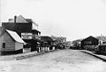 Albert Street c. 1883
 -
 The former Albert Street exit portal for the Queen Street bus station, which has now been converted into part of the Mall.
 -
 Uptown entrance at the intersection of Albert Street and Elizabeth Street, and the Queen Street Mall
 -
 Albert Street Uniting Church


Major intersections edit
See also edit
References edit
- ^ "What's the story behind the men's and women's street names in Brisbane's CBD?". ABC News. 20 December 2017. Archived from the original on 28 November 2018. Retrieved 31 July 2021.
- ^ a b c "Cross River Rail Business Case August 2017" (PDF). Government of Queensland. pp. 130, 131. Archived (PDF) from the original on 23 October 2021. Retrieved 23 October 2021.
- ^ a b "City Centre Master Plan 2014" (PDF). Brisbane City Council. pp. 41, 44. Archived (PDF) from the original on 23 October 2021. Retrieved 24 October 2021.
- ^ "Early Streets of Brisbane (entry 645611)". Queensland Heritage Register. Queensland Heritage Council. Retrieved 8 December 2016.
- ^ Bartlett, George S & Bartlett, Aubrey George & Archive CD Books Australia 2009, Greater Brisbane area : atlases and street directories : set of 4 1931-c1948, Archive CD Books Australia, [Modbury, S. Aust.]
- ^ "King George Square". Brisbane Heritage Register. Brisbane City Council. Retrieved 31 July 2021.
- ^ "Cross River Rail to dominate Queensland election". The Courier Mail. News Corp. 17 June 2017. Archived from the original on 22 December 2020. Retrieved 19 June 2017.
- ^ Raymond Evans and Jacqui Donegan, "The Battle of Brisbane", Politics and Culture.[full citation needed]
- ^ "Albert Park (South) Air Raid Shelter (entry 602474)". Queensland Heritage Register. Queensland Heritage Council. Retrieved 19 June 2013.
- ^ "Perry House (entry 600103)". Queensland Heritage Register. Queensland Heritage Council. Retrieved 19 June 2013.
- ^ "Albert Street Uniting Church (entry 600066)". Queensland Heritage Register. Queensland Heritage Council. Retrieved 19 June 2013.
- ^ "123 Albert Street – Building profile – Overview". Dexus Property Group. Archived from the original on 25 April 2012. Retrieved 22 July 2012.
External links edit
![]() Media related to Albert Street, Brisbane at Wikimedia Commons
Media related to Albert Street, Brisbane at Wikimedia Commons