


Summary
Alcala, officially the Municipality of Alcala (Pangasinan: Baley na Alcala; Ilocano: Ili ti Alcala; Tagalog: Bayan ng Alcala), is a 3rd class municipality in the province of Pangasinan, Philippines. According to the 2020 census, it has a population of 48,908 people.[3]
Alcala | |
|---|---|
| Municipality of Alcala | |
 Santo Tomas-Alcala Highway | |
 Flag  Seal | |
| Motto(s): Kalinisan, Kalusugan, Karapatan (English: Environment, Health, Rights) | |
 Map of Pangasinan with Alcala highlighted | |
OpenStreetMap .mw-parser-output .locmap .od{position:absolute}.mw-parser-output .locmap .id{position:absolute;line-height:0}.mw-parser-output .locmap .l0{font-size:0;position:absolute}.mw-parser-output .locmap .pv{line-height:110%;position:absolute;text-align:center}.mw-parser-output .locmap .pl{line-height:110%;position:absolute;top:-0.75em;text-align:right}.mw-parser-output .locmap .pr{line-height:110%;position:absolute;top:-0.75em;text-align:left}.mw-parser-output .locmap .pv>div{display:inline;padding:1px}.mw-parser-output .locmap .pl>div{display:inline;padding:1px;float:right}.mw-parser-output .locmap .pr>div{display:inline;padding:1px;float:left}html.skin-theme-clientpref-night .mw-parser-output .od,html.skin-theme-clientpref-night .mw-parser-output .od .pv>div,html.skin-theme-clientpref-night .mw-parser-output .od .pl>div,html.skin-theme-clientpref-night .mw-parser-output .od .pr>div{background:#000;color:#fff}html.skin-theme-clientpref-night .mw-parser-output .locmap{filter:grayscale(0.6)}@media(prefers-color-scheme:dark){html.skin-theme-clientpref-os .mw-parser-output .locmap{filter:grayscale(0.6)}html.skin-theme-clientpref-os .mw-parser-output .od,html.skin-theme-clientpref-os .mw-parser-output .od .pv>div,html.skin-theme-clientpref-os .mw-parser-output .od .pl>div,html.skin-theme-clientpref-os .mw-parser-output .od .pr>div{background:#000;color:#fff}}  Alcala Location within the Philippines | |
| Coordinates: 15°50′48″N 120°31′19″E / 15.846794°N 120.521822°E | |
| Country | Philippines |
| Region | Ilocos Region |
| Province | Pangasinan |
| District | 5th district |
| Founded | September 20, 1875 |
| Barangays | 16 (see Barangays) |
| Government | |
| • Type | Sangguniang Bayan |
| • Mayor | Jojo B. Callejo |
| • Vice Mayor | Rodolfo C. Rosquita |
| • Representative | Ramon V. Guico III |
| • Municipal Council | Members |
| • Electorate | 30,948 voters (2022) |
| Area | |
| • Total | 45.71 km2 (17.65 sq mi) |
| Elevation | 23 m (75 ft) |
| Highest elevation | 53 m (174 ft) |
| Lowest elevation | 15 m (49 ft) |
| Population (2020 census)[3] | |
| • Total | 48,908 |
| • Density | 1,100/km2 (2,800/sq mi) |
| • Households | 11,999 |
| Economy | |
| • Income class | 3rd municipal income class |
| • Poverty incidence | 12.24 |
| • Revenue | ₱ 151.8 million (2020) |
| • Assets | ₱ 394.5 million (2020) |
| • Expenditure | ₱ 144.1 million (2020) |
| • Liabilities | ₱ 33.25 million (2020) |
| Service provider | |
| • Electricity | Central Pangasinan Electric Cooperative (CENPELCO) |
| Time zone | UTC+8 (PST) |
| ZIP code | 2425 |
| PSGC | 015504000 |
| IDD : area code | +63 (0)75 |
| Native languages | Pangasinan Ilocano Tagalog |
| Major religions | Roman Catholic |
| Feast date | May 3(Feast of the Finding of the True Cross) |
| Catholic diocese | Roman Catholic Diocese of Urdaneta |
| Patron saint | Santa Cruz de Alcala |
Alcala recently broke the world record for longest grill measuring about 3 kilometres (9,840 ft).[citation needed]
History edit
What is known now as Alcala was formerly a barrio of Bayambang, formerly called "Dangla", a vernacular term referring to a medicinal shrub which grows abundantly in the place. As a barrio, it was subdivided into several smaller units called sitios, namely: Bugyao, Bacud, Cupi, Bitulao, Cabicalan, Patalan, Camanggaan and Sinabaan
On April 1, 1873, the settlers established a community. They submitted a petition calling for the cessation of Dangla into a separate township, but it took more than two years for the Spanish Authorities to take notice of the settlers' demands.
Finally, on September 20, 1875, a Royal Decree No. 682 was issued making the place an official municipality to be named Alcala, the name of a town in Spain where the then Governor of Pangasinan hailed from.
During the outbreak of the Philippine–American War, the place was the site of the field headquarters of General Malone of the United States Army.
When the Filipinos and Americans were fighting against the Japanese during World War II, the place was the site for the American Field Headquarters under the command of General Johnathan Wainwright. It is here that the first Guerrilla Combat Training School was established. The same school produced an Infantry Battalion composed mostly of Alcaleneans who played an important role in defending the whole of Northern Luzon from the superior Japanese Forces.[5][6]
Geography edit
Alcala has a land area of 5,508 hectares. It is 49 kilometres (30 mi) from Lingayen and 181 kilometres (112 mi) from Manila.
Barangays edit
Alcala is politically subdivided into 21 barangays.[7] Each barangay consists of puroks and some have sitios.
- Anulid
- Atainan
- Bersamin
- Canarvacanan
- Caranglaan
- Curareng
- Gualsic
- Kisikis
- Laoac
- Macayo
- Pindangan Centro
- Pindangan East
- Pindangan West
- Poblacion East
- Poblacion West
- San Juan
- San Nicolas
- San Pedro Apartado
- San Pedro Ili
- San Vicente
- Vacante
Climate edit
| Climate data for Alcala, Pangasinan | |||||||||||||
|---|---|---|---|---|---|---|---|---|---|---|---|---|---|
| Month | Jan | Feb | Mar | Apr | May | Jun | Jul | Aug | Sep | Oct | Nov | Dec | Year |
| Mean daily maximum °C (°F) | 31 (88) |
31 (88) |
31 (88) |
33 (91) |
32 (90) |
32 (90) |
30 (86) |
30 (86) |
30 (86) |
31 (88) |
31 (88) |
31 (88) |
31 (88) |
| Mean daily minimum °C (°F) | 21 (70) |
21 (70) |
22 (72) |
24 (75) |
24 (75) |
24 (75) |
23 (73) |
23 (73) |
23 (73) |
23 (73) |
23 (73) |
22 (72) |
23 (73) |
| Average precipitation mm (inches) | 5.1 (0.20) |
11.6 (0.46) |
21.1 (0.83) |
27.7 (1.09) |
232.9 (9.17) |
350.8 (13.81) |
679.8 (26.76) |
733.1 (28.86) |
505 (19.9) |
176.6 (6.95) |
67.2 (2.65) |
17.7 (0.70) |
2,828.6 (111.38) |
| Average rainy days | 3 | 3 | 3 | 4 | 14 | 18 | 23 | 25 | 22 | 15 | 8 | 4 | 142 |
| Source: World Weather Online[8] | |||||||||||||
Demographics edit
| Year | Pop. | ±% p.a. |
|---|---|---|
| 1903 | 9,008 | — |
| 1918 | 9,054 | +0.03% |
| 1939 | 12,697 | +1.62% |
| 1948 | 17,064 | +3.34% |
| 1960 | 20,297 | +1.46% |
| 1970 | 22,208 | +0.90% |
| 1975 | 24,376 | +1.89% |
| 1980 | 24,993 | +0.50% |
| 1990 | 30,684 | +2.07% |
| 1995 | 31,974 | +0.77% |
| 2000 | 35,734 | +2.41% |
| 2007 | 38,934 | +1.19% |
| 2010 | 41,077 | +1.97% |
| 2015 | 43,402 | +1.05% |
| 2020 | 48,908 | +2.38% |
| Source: Philippine Statistics Authority[9][10][11][12] | ||
Economy edit
Government edit
Local government edit
Alcala, belonging to the fifth congressional district of the province of Pangasinan, is governed by a mayor designated as its local chief executive and by a municipal council as its legislative body in accordance with the Local Government Code. The mayor, vice mayor, and the councilors are elected directly by the people through an election which is being held every three years.
Elected officials edit
| Position | Name |
|---|---|
| Congressman | Ramon V. Guico III |
| Mayor | Jojo B. Callejo |
| Vice-Mayor | Rodolfo C. Rosquita |
| Councilors | Eduardo B. dela Cruz Jr. |
| Eddie Bauzon | |
| Marcelino Tercias | |
| Ryan Catalan | |
| Johnny E. Carajay | |
| Chebeth Mamitag | |
| Gerardo Ablao | |
| Top Jigur Peregrino |
Tourism edit
A tilapia dispersal and barbecue are part of the attractions in Alcala.[22]
The 2012 Red Bikini Open was held in San Juan.[23]
Alcala celebrated the founding anniversary and annual Tukar Festival (Music Festival) every September 20
Alcala celebrated their fiesta on May 1–3
San Vicente, Alcala has its Backpack Project.
Holy Cross Parish Church edit
The 1881 Holy Cross Parish Church is a Vicariate of Sacred Heart. Its Feast Day are May 3 is the Feast of the Finding of the True Cross and September 14 is the Feast of the Exaltation of the Holy Cross, with the present Parish Priest, Rev. Fr. Christopher Elisar "Ralphie" M. Itchon under the jurisdiction of the Roman Catholic Diocese of Urdaneta.
The January 4, 1881 Spanish Royal Decree of the Spanish Government created the Parish of the Holy Cross and accepted by the Dominicans (House of the Order) on November of 188. Padre Eduardo Saamaniego, O.P., was appointed first parish priest on February 21, 1882. The convent was erected under Fr. Revilla and Fr. Casamitjana but the same was destroyed.[24]
In 1950, Padre Jose V. Ferrer caused the destruction of the old church and instead built a semi-concrete edifice. Aided by Bishop Jesus Sison and Archbishop Mariano Madriaga, the Priest founded the Holy Rood Academy. Fr. Amado Lopez continued the rehabilitation of the Church and school but the 1967 and 1968 Casiguran earthquake annihilated the Church. Thus, Fr. Eusebio Vigilia and Fr. Johnny Tagalicud (1972-1977) rehabilitated the present new Church. (Source, 2007 Fiesta Yearbook of Bani, Pangasinan Church).
-
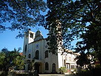 Facade of the Holy Cross Parish (F-1881) Parish Church
 -
 Bell tower
 -
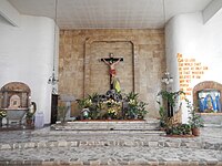 Main altar
 -
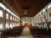 Interior


Education edit
Elementary schools edit
- Alcala Central School
- South Central School
- Anulid Elem. School
- Atainan Elem. School
- Bersamin Elem. School
- Gualsic Elem. School
- Guinawedan Elem. School
- Laoac Elem. School
- Macayo Integrated School
- Pindangan West Elem. School
- Pindangan East Elem. School
- San Juan Elem. School
- San Pedro Apartado Elem. School
- San Pedro Ili Elem. School
- San Vicente Elem. School
- Vacante Elem. School
Secondary schools edit
- Cipriano P. Primicias National High School
- Arboleda National High School
- Pindangan National High School
- Canarvacanan National High School
- San Pedro Apartado National High School
- Bersamin Agro-Industrial High School
- Macayo Integrated School
Private schools edit
- Holy Rood Academy
- Holy Family Inc.
- God's Favor Learning Center Inc.
Gallery edit
-
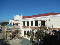 Municipal Hall
 -
 Teachers street
 -
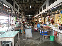 Alcala public market
 -
 The Agno River
 -
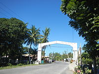 Welcome arch


References edit
- ^ Municipality of Alcala | (DILG)
- ^ "2015 Census of Population, Report No. 3 – Population, Land Area, and Population Density" (PDF). Philippine Statistics Authority. Quezon City, Philippines. August 2016. ISSN 0117-1453. Archived (PDF) from the original on May 25, 2021. Retrieved July 16, 2021.
- ^ a b Census of Population (2020). "Region I (Ilocos Region)". Total Population by Province, City, Municipality and Barangay. Philippine Statistics Authority. Retrieved 8 July 2021.
- ^ "PSA Releases the 2018 Municipal and City Level Poverty Estimates". Philippine Statistics Authority. 15 December 2021. Retrieved 22 January 2022.
- ^ "Alcala | the Official Website of the Province of Pangasinan and its People". Archived from the original on 2012-03-28. Retrieved 2012-12-17.
- ^ "Alcala, Pangasinan Video | Tourism and Events". Archived from the original on 2013-12-10. Retrieved 2012-12-17.
- ^ "Province: PANGASINAN". PSGC Interactive. Makati, Philippines: National Statistical Coordination Board. Archived from the original on 14 November 2012. Retrieved 26 November 2012.
- ^ "Alcala, Pangasinan: Average Temperatures and Rainfall". World Weather Online. Retrieved 23 September 2015.
- ^ Census of Population (2015). "Region I (Ilocos Region)". Total Population by Province, City, Municipality and Barangay. Philippine Statistics Authority. Retrieved 20 June 2016.
- ^ Census of Population and Housing (2010). "Region I (Ilocos Region)" (PDF). Total Population by Province, City, Municipality and Barangay. National Statistics Office. Retrieved 29 June 2016.
- ^ Censuses of Population (1903–2007). "Region I (Ilocos Region)". Table 1. Population Enumerated in Various Censuses by Province/Highly Urbanized City: 1903 to 2007. National Statistics Office.
{{cite encyclopedia}}: CS1 maint: numeric names: authors list (link) - ^ "Province of Pangasinan". Municipality Population Data. Local Water Utilities Administration Research Division. Retrieved 17 December 2016.
- ^ "Poverty incidence (PI):". Philippine Statistics Authority. Retrieved December 28, 2020.
- ^ "Estimation of Local Poverty in the Philippines" (PDF). Philippine Statistics Authority. 29 November 2005.
- ^ "2003 City and Municipal Level Poverty Estimates" (PDF). Philippine Statistics Authority. 23 March 2009.
- ^ "City and Municipal Level Poverty Estimates; 2006 and 2009" (PDF). Philippine Statistics Authority. 3 August 2012.
- ^ "2012 Municipal and City Level Poverty Estimates" (PDF). Philippine Statistics Authority. 31 May 2016.
- ^ "Municipal and City Level Small Area Poverty Estimates; 2009, 2012 and 2015". Philippine Statistics Authority. 10 July 2019.
- ^ "PSA Releases the 2018 Municipal and City Level Poverty Estimates". Philippine Statistics Authority. 15 December 2021. Retrieved 22 January 2022.
- ^ "2019 National and Local Elections" (PDF). Commission on Elections. Retrieved March 7, 2022.
- ^ "2022 ELECTION RESULTS: Alcala, Pangasinan".
- ^ "Tilapia dispersal in Alcala, Pangasinan | the Official Website of the Province of Pangasinan and its People". Archived from the original on 2016-03-04. Retrieved 2012-12-17.
- ^ "San Juan Alcala, Pangasinan Bikini Open 2012 (Red Bikini)". YouTube.
- ^ "Capital of Pangasinan: All Churches in Pangasinan". 18 February 2008.
External links edit
- Alcala Profile at PhilAtlas.com
- Municipal Profile at the National Competitiveness Council of the Philippines
- Alcala at the Pangasinan Government Website
- Alcala Page
- Local Governance Performance Management System
- Philippine Standard Geographic Code
- Philippine Census Information