


Summary
Allas-Champagne is a commune in the Charente-Maritime department in the Nouvelle-Aquitaine region of southwestern France.
Allas-Champagne | |
|---|---|
 The road into Allas-Champagne | |
 Coat of arms | |
Location of Allas-Champagne .mw-parser-output .locmap .od{position:absolute}.mw-parser-output .locmap .id{position:absolute;line-height:0}.mw-parser-output .locmap .l0{font-size:0;position:absolute}.mw-parser-output .locmap .pv{line-height:110%;position:absolute;text-align:center}.mw-parser-output .locmap .pl{line-height:110%;position:absolute;top:-0.75em;text-align:right}.mw-parser-output .locmap .pr{line-height:110%;position:absolute;top:-0.75em;text-align:left}.mw-parser-output .locmap .pv>div{display:inline;padding:1px}.mw-parser-output .locmap .pl>div{display:inline;padding:1px;float:right}.mw-parser-output .locmap .pr>div{display:inline;padding:1px;float:left}html.skin-theme-clientpref-night .mw-parser-output .od,html.skin-theme-clientpref-night .mw-parser-output .od .pv>div,html.skin-theme-clientpref-night .mw-parser-output .od .pl>div,html.skin-theme-clientpref-night .mw-parser-output .od .pr>div{background:#000;color:#fff}html.skin-theme-clientpref-night .mw-parser-output .locmap{filter:grayscale(0.6)}@media(prefers-color-scheme:dark){html.skin-theme-clientpref-os .mw-parser-output .locmap{filter:grayscale(0.6)}html.skin-theme-clientpref-os .mw-parser-output .od,html.skin-theme-clientpref-os .mw-parser-output .od .pv>div,html.skin-theme-clientpref-os .mw-parser-output .od .pl>div,html.skin-theme-clientpref-os .mw-parser-output .od .pr>div{background:#000;color:#fff}}  Allas-Champagne  Allas-Champagne | |
| Coordinates: 45°28′15″N 0°20′20″W / 45.4708°N 0.3389°W | |
| Country | France |
| Region | Nouvelle-Aquitaine |
| Department | Charente-Maritime |
| Arrondissement | Jonzac |
| Canton | Jonzac |
| Intercommunality | Haute Saintonge |
| Government | |
| • Mayor (2020–2026) | Bernard Maindron[1] |
| Area 1 | 7.65 km2 (2.95 sq mi) |
| Population (2021)[2] | 248 |
| • Density | 32/km2 (84/sq mi) |
| Time zone | UTC+01:00 (CET) |
| • Summer (DST) | UTC+02:00 (CEST) |
| INSEE/Postal code | 17006 /17500 |
| Elevation | 35–77 m (115–253 ft) (avg. 67 m or 220 ft) |
| 1 French Land Register data, which excludes lakes, ponds, glaciers > 1 km2 (0.386 sq mi or 247 acres) and river estuaries. | |
Geography edit
Allas-Champagne is located in the south of the department of Charente-Maritime in the former province of Saintonge some 10 km north-east of Jonzac and 5 km south-east of Archiac. It can be accessed by road D250 which comes east from the D699 linking Jonzac and Archiac through the village and continuing east as the D250E1 to Brie-sous-Archiac. There is also the D149 which comes from Archiac in the north passing through the heart of the commune and the village and continuing south to join the D2 road west of Meux. Apart from the village there are three hamlets in the commune: Godais, Chez Gondre, and La Valade. The commune consists entirely of farmland with the exception of a few very small patches of forest in the south.[3]

The Trefle river flows west through the south of the commune forming part of the southern border before continuing westwards to join the Seugne near Saint-Grégoire-d'Ardennes. A small unnamed stream also rises in the north of the commune and flows west then south to join the Trefle.[3]
Administration edit

This list is incomplete; you can help by adding missing items. (April 2021) |
List of Successive Mayors[4]
| From | To | Name | Party | Position |
|---|---|---|---|---|
| 2001 | 2014 | Yves Guénoux | SE | Sales Executive |
| 2014 | 2026 | Bernard Maindron |
Population edit
The inhabitants of the commune are known as Allasiens or Allasiennes in French.[5]
| Year | Pop. | ±% p.a. |
|---|---|---|
| 1968 | 201 | — |
| 1975 | 200 | −0.07% |
| 1982 | 213 | +0.90% |
| 1990 | 207 | −0.36% |
| 1999 | 184 | −1.30% |
| 2007 | 229 | +2.77% |
| 2012 | 272 | +3.50% |
| 2017 | 264 | −0.60% |
| Source: INSEE[6] | ||

Distribution of Age Groups edit
The population of the commune is younger than the departmental average.
Percentage Distribution of Age Groups in Allas-Champagne and Charente-Maritime Department in 2017
| Allas-Champagne | Charente-Maritime | |||
|---|---|---|---|---|
| Age Range | Men | Women | Men | Women |
| 0 to 14 Years | 20.0 | 16.9 | 16.3 | 14.3 |
| 15 to 29 Years | 7.7 | 14.5 | 15.4 | 13.1 |
| 30 to 44 Years | 28.5 | 17.7 | 16.7 | 16.1 |
| 45 to 59 Years | 21.5 | 20.2 | 20.2 | 19.9 |
| 60 to 74 Years | 15.4 | 17.7 | 21.1 | 22.0 |
| 75 to 89 Years | 6.2 | 8.1 | 9.4 | 12.3 |
| 90 Years+ | 0.8 | 4.8 | 1.0 | 2.4 |
Education edit
A public kindergarten is located in the centre of the village.
Sites and monuments edit
- The Church of Saint-Didier from the 12th century.
-
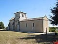 The Church of Saint Didier
 -
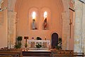 Church of Saint Didier Interior
 -
 Stained Glass in the Church
 -
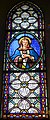 Stained Glass in the Church


Transport edit
Nearest Railway stations and halts edit
- Jonzac (9 km)
- Fontaines-d'Ozillac (halt) (9.9 km)
- Clion-sur-Seugne (halt) (13.1 km)
- Pons (20 km)
- Montendre (21.6 km)
Nearest Airports and airfields edit
See also edit
References edit
- ^ "Répertoire national des élus: les maires". data.gouv.fr, Plateforme ouverte des données publiques françaises (in French). 2 December 2020.
- ^ "Populations légales 2021". The National Institute of Statistics and Economic Studies. 28 December 2023.
- ^ a b Google Maps
- ^ List of Mayors of France
- ^ Le nom des habitants du 17 - Charente-Maritime, habitants.fr
- ^ a b Évolution et structure de la population en 2017: Commune d'Allas-Champagne (17006)
- ^ Évolution et structure de la population en 2017: Département de la Charente-Maritime (17)
External links edit
- Allas-Champagne on the National Geographic Institute website (in French)
- Allas-Champagne on Géoportail, National Geographic Institute (IGN) website (in French)
- Allas-Champagne on the 1750 Cassini Map