


Summary
The Allerton Avenue station is a local station on the IRT White Plains Road Line of the New York City Subway. Located in the shopping district of Allerton, Bronx, at Allerton Avenue and White Plains Road,[4] it is served by the 2 train at all times and by the 5 train during rush hours in the peak direction.
Allerton Avenue | ||||||||||||||||||||||||||||||||||||||||||||||||||||||||||||||||||||
|---|---|---|---|---|---|---|---|---|---|---|---|---|---|---|---|---|---|---|---|---|---|---|---|---|---|---|---|---|---|---|---|---|---|---|---|---|---|---|---|---|---|---|---|---|---|---|---|---|---|---|---|---|---|---|---|---|---|---|---|---|---|---|---|---|---|---|---|---|
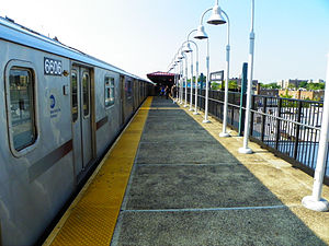 An R142 train sits at the station | ||||||||||||||||||||||||||||||||||||||||||||||||||||||||||||||||||||
| Station statistics | ||||||||||||||||||||||||||||||||||||||||||||||||||||||||||||||||||||
| Address | Allerton Avenue & White Plains Road Bronx, NY 10467 | |||||||||||||||||||||||||||||||||||||||||||||||||||||||||||||||||||
| Borough | The Bronx | |||||||||||||||||||||||||||||||||||||||||||||||||||||||||||||||||||
| Locale | Allerton | |||||||||||||||||||||||||||||||||||||||||||||||||||||||||||||||||||
| Coordinates | 40°51′54″N 73°52′01″W / 40.865°N 73.867°W | |||||||||||||||||||||||||||||||||||||||||||||||||||||||||||||||||||
| Division | A (IRT)[1] | |||||||||||||||||||||||||||||||||||||||||||||||||||||||||||||||||||
| Line | IRT White Plains Road Line | |||||||||||||||||||||||||||||||||||||||||||||||||||||||||||||||||||
| Services | 2 5 | |||||||||||||||||||||||||||||||||||||||||||||||||||||||||||||||||||
| Transit | ||||||||||||||||||||||||||||||||||||||||||||||||||||||||||||||||||||
| Structure | Elevated | |||||||||||||||||||||||||||||||||||||||||||||||||||||||||||||||||||
| Platforms | 2 side platforms | |||||||||||||||||||||||||||||||||||||||||||||||||||||||||||||||||||
| Tracks | 3 | |||||||||||||||||||||||||||||||||||||||||||||||||||||||||||||||||||
| Other information | ||||||||||||||||||||||||||||||||||||||||||||||||||||||||||||||||||||
| Opened | March 3, 1917 | |||||||||||||||||||||||||||||||||||||||||||||||||||||||||||||||||||
| Opposite- direction transfer | Yes | |||||||||||||||||||||||||||||||||||||||||||||||||||||||||||||||||||
| Traffic | ||||||||||||||||||||||||||||||||||||||||||||||||||||||||||||||||||||
| 2023 | 874,229[2] | |||||||||||||||||||||||||||||||||||||||||||||||||||||||||||||||||||
| Rank | 315 out of 423[2] | |||||||||||||||||||||||||||||||||||||||||||||||||||||||||||||||||||
| ||||||||||||||||||||||||||||||||||||||||||||||||||||||||||||||||||||
| ||||||||||||||||||||||||||||||||||||||||||||||||||||||||||||||||||||
| ||||||||||||||||||||||||||||||||||||||||||||||||||||||||||||||||||||
| ||||||||||||||||||||||||||||||||||||||||||||||||||||||||||||||||||||
| ||||||||||||||||||||||||||||||||||||||||||||||||||||||||||||||||||||


History edit
This station was built under the Dual Contracts. It opened on March 3, 1917, as part of an extension of the IRT White Plains Road Line from East 177th Street–East Tremont Avenue to East 219th Street–White Plains Road, providing the Bronx communities of Williamsbridge and Wakefield with access to rapid transit service. Service on the new portion of the line was operated as a four-car shuttle from 177th Street due to the power conditions at the time.[5][6][7] The city government took over the IRT's operations on June 12, 1940.[8][9]
This station was renovated in early 2005 at a cost of $12.76 million.[10]
Station layout edit
| Platform level | Side platform | |
| Northbound local | ← ← | |
| Peak-direction express | ← | |
| Southbound local | | |
| Side platform | ||
| Mezzanine | Fare control, station agent, MetroCard machines | |
| Ground | Street level | Entrances/exits |
This elevated station has three tracks and two side platforms.[11]
Both platforms have beige windscreens and red canopies with green outlines, frames, and support columns in the center and black, waist-high steel fences at either ends with lampposts at regular intervals. The windscreens have mesh fences at various points. The station signs are in the standard black name plates with white lettering.
The 2006 artwork here is called Allerton Mandalas by Michele Brody. It consists of stained glass panels on the platform windscreens featuring twisting colors of red and green (representing the trunk lines of the 2 and 5 trains).[12][13]
Exits edit
This station has one elevated station house beneath the center of the platforms and tracks. Two staircases from each platform go down a waiting area. The back of the token booth faces this crossunder with a steel fences on either side. On the Wakefield-bound side, there are two exit only turnstiles. On the Manhattan-bound side, there is an emergency gate and a bank of three turnstiles. Outside fare control, two staircases go down to the northwest and southeast corners of Allerton Avenue and White Plains Road. The station house has windows.[14]
References edit
- ^ "Glossary". Second Avenue Subway Supplemental Draft Environmental Impact Statement (SDEIS) (PDF). Vol. 1. Metropolitan Transportation Authority. March 4, 2003. pp. 1–2. Archived from the original (PDF) on February 26, 2021. Retrieved January 1, 2021.
- ^ a b "Annual Subway Ridership (2018–2023)". Metropolitan Transportation Authority. 2023. Retrieved April 20, 2024.
- ^ "Annual Subway Ridership (2018–2023)". Metropolitan Transportation Authority. 2023. Retrieved April 20, 2024.
- ^ "Neighborhood Map Pelham Parkway Olinville Pelham Gardens Morris Park" (PDF). mta.info. Metropolitan Transportation Authority. 2015. Retrieved October 2, 2016.
- ^ "Annual report. 1916-1917". HathiTrust. Interborough Rapid Transit Company. December 12, 2013. hdl:2027/mdp.39015016416920. Retrieved September 5, 2016.
- ^ "New Subway Line Opened: White Plains Extension is Now Running to 238th Street" (PDF). The New York Times. April 1, 1917. ISSN 0362-4331. Archived (PDF) from the original on March 24, 2020. Retrieved August 17, 2015.
- ^ "White Plains Road Extension of Subway Opened to the Public; New Branch, Which Runs from 177th to 219th Street, Gives the Williamsbridge and Wakefield Sections of the East Bronx Rapid Transit for the First Time" (PDF). The New York Times. March 4, 1917. ISSN 0362-4331. Archived (PDF) from the original on March 23, 2020.
- ^ "City Transit Unity Is Now a Reality; Title to I.R.T. Lines Passes to Municipality, Ending 19-Year Campaign". The New York Times. June 13, 1940. ISSN 0362-4331. Archived from the original on January 7, 2022. Retrieved May 14, 2022.
- ^ "Transit Unification Completed As City Takes Over I. R. T. Lines: Systems Come Under Single Control After Efforts Begun in 1921; Mayor Is Jubilant at City Hall Ceremony Recalling 1904 Celebration". New York Herald Tribune. June 13, 1940. p. 25. ProQuest 1248134780.
- ^ MTA 2006 Adopted Budget - February Financial Plan - Part 3 (PDF) (Report). Metropolitan Transportation Authority. 2006. p. 46. Archived from the original (PDF) on May 24, 2019. Retrieved March 27, 2020.
- ^ Dougherty, Peter (2006) [2002]. Tracks of the New York City Subway 2006 (3rd ed.). Dougherty. OCLC 49777633 – via Google Books.
- ^ "MTA - Arts & Design | NYCT Permanent Art". web.mta.info. Retrieved October 2, 2016.
- ^ "www.nycsubway.org: Artwork: Allerton Mandalas (Michele Brody)". www.nycsubway.org. Retrieved October 2, 2016.
- ^ "Allerton Avenue Neighborhood Map" (PDF). new.mta.info. Metropolitan Transportation Authority. April 2018. Retrieved February 28, 2019.
External links edit
- nycsubway.org – IRT White Plains Road Line: Allerton Avenue
- nycsubway.org — Allerton Mandalas Artwork by Michele Brody (2006)
- The Subway Nut — Allerton Avenue Pictures Archived March 25, 2010, at the Wayback Machine
- MTA's Arts For Transit — Allerton Avenue (IRT White Plains Road Line)
- Allerton Avenue entrance from Google Maps Street View
- Platforms from Google Maps Street View