


Summary
Allied Command Europe Highband, better known as ACE High, was a fixed service NATO radiocommunication and early warning system dating back to 1956. After extensive testing ACE High was accepted by NATO to become operational in 1964/1965.
The frequency supportability and frequency assignments were provided in accordance with the NATO Joint Civil/Military Frequency Agreement (NJFA). The system was designed to be a combined UHF troposcatter/microwave radio system, providing long-range communications in the form of telephone, telegraph and data traffic in the NATO chain of command.[1]
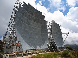
Its combined services produced over 200 channels and equipment was in place to multiplex them to contain up to 12 different calls each. There used to be 49 troposcatter links augmented by 40 Line Of Sight Microwave terrestrial stations, located in nine different NATO countries from northern Norway through central Europe to eastern Turkey. The transmitters broadcast at 832.56 - 959.28 MHz producing an average transmitting power of 10 kilowatts.[2]
History edit
NATO had been established in 1949 with then a supreme command (SHAPE) near Versailles, France, and the regional headquarters (RHQ) Allied Forces Northern Europe (AFNORTH) at Kolsås, Norway (responsible for Denmark, Norway and the UK), Allied Forces Central Europe (AFCENT) at Laffaux, France (responsible for Belgium, France, Germany and the Netherlands) and Allied Forces Southern Europe (AFSOUTH) at Naples, Italy (responsible for Italy, Greece and Turkey). Supreme command, the three RHQ's and all subordinated units used various communication systems to establish contact: high frequency radio networks, VHF beaming transmitters and civil or military landlines. All systems had their weakness in equipment reliability; in the maximum amount of data transferred; in encryption possibilities and in unauthorized data interception. So in the early 1950s there existed an urgent need for a reliable, foolproof long distance European communications network.
US developed tropospheric diffusion techniques, integrated in a new military communications network appeared to be the solution and in 1956 STC, a planning, design, engineering and installation company had been ordered to develop a new integrated communications network in Europe. This network consisted of a number of "backbone" stations covering the 6,800 km (4,200 mi) distance from the north of Norway to the south of Turkey and was initially called the "Over the Horizon Troposperic scatter Communications Net" but was renamed "Allied Command Europe - Highband" (ACE-High). The network would be kept operational until the 1990s as all frequencies then had to be released to the civilian authorities.
After all components had been installed on their locations by Marconi Electronic Systems UK, (from 1968 part of General Electric Company), in 1961 the ACE-High system had officially been transferred to NATO.
In 1966 however France, under president Charles de Gaulle, withdrew from NATO integrated military structure (not from the Alliance itself) and systems had to be rerouted from France to Brunssum, Netherlands while the former Primary Control Center at Beauvais, was relocated to Lamersdorf, West-Germany.
In the early 1970s, the first geostationary satellites in the "Satellite Communication" network (SATCOM) had been activated thus expanding the ACE-High system.
The rise of the military SATCOM I-III (1971-1994), SATCOM IV (1995-now) network satellites, Internet routers, and the Central Region Integrated Communication System (CRICS) and the Crisis Response Operations in NATO Operating Systems (CRONOS) made ACE High obsolete. By the end of the 1980s, its replacement was already available but NATO postponed the ACE High phasing-out until 1995.[citation needed]
In 1995, the first British NATO SATCOM IV/B satellites had been activated and because the ACE-High frequencies had to be released for civil TV and mobile phone usage NATO decided to deactivate ACE-High in 1996, and the 800 MHz band frequencies became available for civilian use again.[citation needed]
ACE High sites edit
The ACE High network included the following major sites and terminals, but also connected Line of Sight (LOS) microwave links to other networks reaching C2 centres not listed here.[3]
- AFNORTH-Norway
- (NC- Senja) > NSEZ
Pos 69°19′44″N 17°29′49″E / 69.32889°N 17.49694°E TX RX Equipment:1 Scatter Line + 2 Radio Line
- (nca - Höggumpen) > NHGZ
Pos 69°04′41″N 18°00′16″E / 69.07806°N 18.00444°E 502 m TX RX Equipment:1 Radio Line
- (ND- Bodö) > NKLZ
Pos 67°10′23″N 15°01′24″E / 67.17306°N 15.02333°E 801 m TX RX Equipment:2 Scatter Line + 1 Radio Line
- (nda - Bodoe Tail - Kletkov) > NVAZ Pos unbekannt
TX RX Equipment:1 Radio Line
- (NE - Mosjöen) > NMOZ
Pos 65°52′41″N 13°18′11″E / 65.87806°N 13.30306°E 627 m TX RX Equipment:2 Scatter Line
- (NF - Trondheim) > NSBZ
Pos 63°18′41″N 10°56′17″E / 63.31139°N 10.93806°E 677 m AMSL TX RX Equipment:2 Scatter Line + 1 Radio Line
- (nfa - Trondheim Tail - Graakallen)
Pos 63°25′15″N 10°15′06″E / 63.42083°N 10.25167°E 543 m AMSL TX RX Equipment:1 Radio Line
- (NG - Oslo AAA) > NSOZ
Pos 60°03′34″N 11°16′09″E / 60.05944°N 11.26917°E 246 m TX RX Equipment:2 Scatter Line + 1 Radio Line
- (Oslo YYY - Svartas) > NVAZ
Pos 68°18′3″N 14°14′16″E / 68.30083°N 14.23778°E TX RX Equipment:3 Radio Line
- (nga - Oslo Tail 01 - Kolsaas) > NKOZ
Pos 59°55′7″N 10°30′58″E / 59.91861°N 10.51611°E TX RX Equipment:1 Radio Line
- (ngb - Oslo Tail 02 - Maakeroy) > NVEZ
Pos 59°09′22″N 10°26′19″E / 59.15611°N 10.43861°E 14 m TX RX Equipment:1 Radio Line
- (NH - Grimstad - Stormyrheia/hørte) > NSMZ
Pos 58°27′19″N 08°27′43″E / 58.45528°N 8.46194°E 326 m TX Rx Equipment:3 Scatter Line
- (NJ - Sola - Lysenut) > NLYZ
Pos 59°31′40″N 05°54′12″E / 59.52778°N 5.90333°E 792 m TX RX Equipment:2 Scatter Line
- AFNORTH-Denmark
- (DA - Karup - Torphøj) > DTOZ
Pos 55°52′28″N 09°21′00″E / 55.87444°N 9.35000°E 135 m TX RX Equipment:2 Scatter Line + 1 Radio Line
- (daa - Karup Tail - Lundbakke) > DLUZ
Pos 56°13′49″N 09°09′48″E / 56.23028°N 9.16333°E 68 m TX RX Equipment:1 Radio Line
- AFNORTH-United Kingdom
- (EAA - Faroes - Sandfelli 2)
- (EA - Shetlands - Mossy Hill) > UMSZ - Mossy Hill > 59°57′17.15″N 01°18′11.60″W / 59.9547639°N 1.3032222°W 227 m AMSL
- (eab - Shetlands Tail Relay - Collofirth Hill) > UCOZ - Collafirth Hill > 60°32′00.75″N 01°23′28.30″W / 60.5335417°N 1.3911944°W 239 m AMSL
- (eac - Shetlands Tail - Saxa Vord) USVZ - Saxa Vord 60°49′37.20″N 00°50′22.59″W / 60.8270000°N 0.8396083°W 276 m AMSL
- (EB - Aberdeen - Mormond Hill) > UMOZ - Mormond Hill 57°36′11.19″N 02°01′51.86″W / 57.6031083°N 2.0310722°W 227 m AMSL
- (eba - Aberdeen Tail - Long Haven Hill) > UBUZ - Long Haven Hill 57°27′31.94″N 1°48′46.07″W / 57.4588722°N 1.8127972°W 95 m AMSL
- (EC - Boulmer - Brizlee Wood) > UBOZ - Brizlee Wood 55°25′05.28″N 1°46′04.26″W / 55.4181333°N 1.7678500°W 250 m AMSL
- (ED - Binbrook - Stenigot) > UBIZ - Stenigot 53°19′36.08″N 00°06′57.44″E / 53.3266889°N 0.1159556°E 153 m AMSL
- (EE - London - Coldblow Lane) > UMAZ - Coldblow Lane 51°17′44.95″N 00°36′51.52″E / 51.2958194°N 0.6143111°E 194 m AMSL
- (eeb - London Tail Relay - Woldingham - RAF Botley Hill Farm)
- (eea - London tail - Hillingdon)
- RAF Uxbridge – local terminus
- AFCENT-France
- (FAN - Paris - Mont Florentin) FFLZ - Paris North 49°20′27.59″N 02°03′06.79″E / 49.3409972°N 2.0518861°E 222 m AMSL
- FTAZ - Taverny 49°02′02.88″N 02°13′45.85″E / 49.0341333°N 2.2294028°E 178 m AMSL
- (fac - Paris Tail (2)- Sant Germain) 48°54′44.67″N 02°01′25.44″E / 48.9124083°N 2.0237333°E 71 m AMSL
- (fae - Paris Tail (2) - Extension (SHAPE) 48°50′34.19″N 02°06′14.30″E / 48.8428306°N 2.1039722°E 178 m AMSL
- (fa - Relais Paris - Emeville) FEMZ - Emeville 49°18′01.83″N 03°00′41.00″E / 49.3005083°N 3.0113889°E 247 m AMSL
- (faa - Paris Tail (1) - Laffaux) 49°27′15.05″N 03°24′57.39″E / 49.4541806°N 3.4159417°E 143 m AMSL
- (fad - Relay Paris - Rozoy Bellevalle) FRBZ - Rozoy Bellevalle 48°55′56.05″N 03°28′24.62″E / 48.9322361°N 3.4735056°E 219 m AMSL
- (FAS - Paris - Mont Aout) FAOZ - Paris South 48°46′14.78″N 03°53′25.33″E / 48.7707722°N 3.8903694°E 216 m AMSL
- (FA - Trier - Rohrbach) FROZ - Rohrbach 49°03′18.47″N 07°14′40.74″E / 49.0551306°N 7.2446500°E 376 m AMSL
- (fay - Trier Tail - Kindsbach) ABHZ - Kindsbach 49°23′48.11″N 07°35′38.32″E / 49.3966972°N 7.5939778°E 458 m AMSL
- (FC - Lyon - Pierre sur Haute) FLYZ - Lyon 45°39′11.52″N 03°48′33.07″E / 45.6532000°N 3.8091861°E 1632 m AMSL
- (FD - Nice - Signal de la Chens) FNIZ - Nice 43°44′53.67″N 06°39′44.85″E / 43.7482417°N 6.6624583°E 1703 m AMSL
- AFCENT-Netherlands
- HBRZ - Brunssum 50°56′19.11″N 05°58′35.60″E / 50.9386417°N 5.9765556°E 95 m AMSL TX equipment 1S + 1R
- HMAZ - Maastricht 50°50′25.05″N 05°39′33.78″E / 50.8402917°N 5.6593833°E 82 m AMSL TX equipment 1S +2R
- AFCENT-Belgium
- BADZ - Adinkerke
- BCAZ - Casteau Supreme HQ Allied Powers Europe Pos 50°30′05.56″N 03°58′15.69″E / 50.5015444°N 3.9710250°E 87 m AMSL TX Equipment 2S +2R
- BCHZ - Chievres Pos 50°35′7.75″N 3°48′59.84″E / 50.5854861°N 3.8166222°E TX Equipment 2S +2R
- BFRZ - Baraque de Fraiture 50°15′07.94″N 05°43′56.13″E / 50.2522056°N 5.7322583°E 654 m AMSL TX Equipment 3R
- AFCENT-Germany
- ABHZ - Kindsbach 49°23′51.24″N 07°35′41.17″E / 49.3975667°N 7.5947694°E 458 m ü. NN
- (AA - Emden - Aurich) AEMZ - Aurich 53°30′32.04″N 07°26′34.83″E / 53.5089000°N 7.4430083°E 10 m ü. NN
- (AB - Moenchengladbach - Roetgen) ALAZ -Lammersdorf 50°39′57.59″N 06°17′14.58″E / 50.6659972°N 6.2873833°E 593 m ü. NN
- (abb - Moenchengladbach Tail (1) - Hehn) AHEZ - Hehn 51°10′51.44″N 06°23′37.77″E / 51.1809556°N 6.3938250°E 81 m ü. NN
- (aba - Moenchengladbach Tail (2) - Millen) 50°45′57.87″N 05°33′47.26″E / 50.7660750°N 5.5631278°E 151 m ü. NN
- (abc - Uedem) AUEZ - Uedem 51°39′39.08″N 06°16′58.97″E / 51.6608556°N 6.2830472°E 47 m ü. NN
- AFEZ - Feldberg 47°52′23.09″N 08°00′59.73″E / 47.8730806°N 8.0165917°E 1458 m ü. NN
- AFSOUTH-Italy
- IDGZ - Dosso dei Galli 45°51′13.66″N 10°22′32.28″E / 45.8537944°N 10.3756333°E 2174 m AMSL
- IVTZ - Verona Tail ( im West Star Bunker ) 45°33′17.89″N 10°45′46.83″E / 45.5549694°N 10.7630083°E 334 m AMSL
- (IA - Livorno - Monte Giogo) IMXZ - Livorno 44°19′17.38″N 10°07′30.94″E / 44.3214944°N 10.1252611°E 1496 m AMSL
- (IAZ - Cavriana - Monte Bosco Scuro) IMBZ - Cavriana 45°21′00.79″N 10°37′01.46″E / 45.3502194°N 10.6170722°E 189 m AMSL
- (iaa - Verona Torre 4) 45°27′11.35″N 11°00′30.55″E / 45.4531528°N 11.0084861°E 164 m AMSL
- (IAY - Lame - Cavanella) ICEZ - Lame Concordia 45°44′55.99″N 12°52′08.75″E / 45.7488861°N 12.8690972°E 7 m AMSL
- (iax - Aviano) IAVZ - Aviano 46°01′23.02″N 12°35′34.19″E / 46.0230611°N 12.5928306°E 99 m AMSL
- (IB - Rome - Tolfa) ITLZ - Rome 42°09′01.76″N 11°54′32.73″E / 42.1504889°N 11.9090917°E 621 m AMSL
- (iba - Rome Tail - Monte Cavo) IMCZ - Monte Cavo 41°45′04.86″N 12°42′31.03″E / 41.7513500°N 12.7086194°E 930 m AMSL
- (IC - Naples - Ischia - Punta Fetto) IICZ - Naples 40°35′50.88″N 13°54′08.54″E / 40.5974667°N 13.9023722°E 639 m AMSL
- (ica - Naples Tail - Monte Pecorara) IPEZ - Monte Petrino 41°13′24.29″N 13°57′57.75″E / 41.2234139°N 13.9660417°E 335 m AMSL
- (icy - Monte Vergine) IMNZ - Monte Nardello 40°56′33.27″N 14°43′07.28″E / 40.9425750°N 14.7186889°E 1516 m AMSL
- (icz - Monte Vulture) IVUZ - Monte Vulture 40°57′03.12″N 15°38′10.75″E / 40.9508667°N 15.6363194°E 1301 m AMSL
- (icv - Monte Iacontenente) IIAZ - Monte Iacontenente 41°47′20.2956″N 16°2′58.0236″E / 41.788971000°N 16.049451000°E
- (icf - Pietra Ficcata) IPFZ - Pietra Ficcata 40°34′04.90″N 16°19′21.31″E / 40.5680278°N 16.3225861°E 586 m AMSL
- (icw - Martina Franca) IAMZ - Martina Franca 40°39′22.968″N 17°17′21.048″E / 40.65638000°N 17.28918000°E
- (ID - Catanzaro - Monte Mancuso) IMMZ - Catanzaro 39°01′09.13″N 16°13′32.02″E / 39.0192028°N 16.2255611°E 1319 m AMSL
- (IDA - Monte Lauro - Cozzo tre Grotte) ICCZ - Monte Lauro 37°06′52.13″N 14°51′18.96″E / 37.1144806°N 14.8552667°E 944 m AMSL
- AFSOUTH-Malta
- (idb - Malta - Gharghur) IDBZ - Malta - Gharghur
- AFSOUTH-Greece
- (GA - Kefallina) > GKFZ - Kefallonia 38°10′11.18″N 20°37′08.53″E / 38.1697722°N 20.6190361°E 1001 m AMSL
- (GB - Athens - Pendelikon) > GPKZ - Athens 38°04′50.46″N 23°52′58.14″E / 38.0806833°N 23.8828167°E 1038 m AMSL
- (GBZ - Crete - Ziros) > GZIZ - Ziros 35°03′53.52″N 26°09′14.24″E / 35.0648667°N 26.1539556°E 786 m AMSL
- (GBY - Larissa - Phillon) > GPIZ - Phillon 39°25′22.75″N 23°03′11.54″E / 39.4229861°N 23.0532056°E 1513 m AMSL
- (GBW - Vitsi) > GVIZ - Vitzi 40°38′43.34″N 21°23′11.07″E / 40.6453722°N 21.3864083°E 2009 m AMSL
- (GBV - Ismaros) > GISZ - Ismaros 40°53′34.67″N 25°32′56.06″E / 40.8929639°N 25.5489056°E 612 m AMSL
- AFSOUTH-Turkey
- (TA - Izmir - Bespinar Tepes) > TBPZ - Izmir - Bespinar Tepes 38°18′48.72″N 27°01′29.89″E / 38.3135333°N 27.0249694°E 964 m AMSL
- (taa - Izmir Tail) > TKYZ - Izmir Tail
- (TB - Eskisehir) > TKUZ - Eskishir - Kutahya Dagi 39°25′03.25″N 29°51′19.07″E / 39.4175694°N 29.8552972°E 1820 m AMSL
- (tba - Eskirsehir Tail) > TESZ - Eskirsehir Tail
- (TC - Ankara) > TEDZ - Ankara - Elan Dagi 39°48′20.59″N 32°59′32.27″E / 39.8057194°N 32.9922972°E 1856 m AMSL
- (TCK - Merzifon) > TKJZ - Merzifon
- (TCW - Persembe) > TPEZ - Persembe
- (TCV - Pazar) > TPAZ - Pazar
- (TD - Siwas - Pinarbasi) > TPIZ - Pinarbasi 38°40′38.09″N 36°24′10.59″E / 38.6772472°N 36.4029417°E 2285 m AMSL
- (TG - Adana) > TDDZ - Davudi Dağı 36°49′39.37″N 35°38′18.66″E / 36.8276028°N 35.6385167°E 515 m AMSL
- (tga - Adana Tail) > TDAZ - Adana Tail
- (TE - Dyarbakir - Karaka Dagi) > TDIZ > Dyarbakir - Karaka Dagi
- (tea - Dyarbakir Tail) > TDEZ - Dyarbakir Tail
- Bloatli, Turkey
- AFSOUTH-Cyprus
- (TCZ - Cap Greco) > JCGZ -Cavo Greko 34°58′00.85″N 34°04′11.41″E / 34.9669028°N 34.0698361°E 62 m AMSL
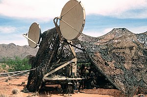
Initially 60, 30 or 15 ft dish or billboard type antennas have been used in combination with General Electric or RCA AN/MRC80 TRC24; AN/FRC-75 or 39 radio sets. Later being replaced by newer Siemens & Halske EM 120/400 and 12/800 types. The type and beaming angle of the antennas depended of the local site position and its distance to the next relays.
See also edit
- Radio propagation
- Tropospheric scatter
- Microwave
- White Alice Communications System - Cold war era Alaskan tropospheric communications link
- List of White Alice Communications System sites
- List of DEW Line Sites
- Distant Early Warning Line
References edit
- ^ http://archives.nato.int/uploads/r/nato-archives-online/0/7/8/0780e4a143f64cb3103978c2bcabc8cddcc409cce87a25584765d522d816a1c2/MCWM-077-66_ENG_PDP.pdf NATO UNCLAS Memorandum MCWM -77-66
- ^ ACE HIGH. SCALE OF THE SYSTEM, Andy Emmerson, 2003 Subterranea Britannica:
- ^ "Troposcatter Communication Networks". rammstein.dfmk.hu.
- ^ Communications-electronics Reference Data, Volume 24,#19
- ^ Operator's, Organizational, Direct Support, General Support, and Depot Maintenance TM's 11-5820-203-15 and 11-5840-401-12
External links edit
- History and details
- Photographs of an installation
- Troposcatter communication network maps
- Website by Gerrit Padberg and Roger Camperi
- Italian Website