


Summary
Ambalavao [amˌbalaˈvaw] is a city (commune urbaine) in Madagascar, in the Haute Matsiatra region. The city is in the most southern part of the Central Highlands, near the city of Fianarantsoa.
Ambalavao | |
|---|---|
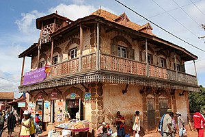 The town centre of Ambalavao as of November 2007 | |
 Coat of arms | |
 Ambalavao Location in Madagascar | |
| Coordinates: 21°50′S 46°56′E / 21.833°S 46.933°E | |
| Country | |
| Province | Haute Matsiatra |
| Population (2001)[1] | |
| • Total | 30,000 |
| • Ethnicities | Betsileo |
| Postal code | 303 |
| Climate | Cwa |
Nature edit
- The Anja Community Reserve, situated about 13 km south of Ambalavao, is a small community-based reserve created to preserve and manage local natural resources.
- Andringitra National Park is located near this city.
Geography edit
Ambalavao is situated at the National road 7 Fianarantsoa-Ihosy-Tuléar at 160 km from Ihosy and 56 km from Fianarantsoa.[2]
Sights edit


The Bureau de la Zone Administrative is a colonial building built of tiles with a flight of outdoor stairs around 1920.[3] Saint Joseph Church is a large catholic church which was built of tiles in a neogothic style in the first quarter of the 20th century.[4]
Ambalavao is known for its silk production based on the breeding of a special species of silkworms which feeds on tapia trees.[5] A silk weaving mill can be visited in the northern part of the town.
Ambalavao is also known for the production of Antemoiro paper of the bark of Avoha bushes, a species of morus.[6] A workshop can be visited in the town centre.
A zebu market is held twice a week.
Anja Community Reserve is a sightworthy natural reserve famous for its ring-tailed lemurs.
Climate edit
Ambalavao has a humid subtropical climate (Köppen: Cwa).
| Climate data for Ambalavao | |||||||||||||
|---|---|---|---|---|---|---|---|---|---|---|---|---|---|
| Month | Jan | Feb | Mar | Apr | May | Jun | Jul | Aug | Sep | Oct | Nov | Dec | Year |
| Daily mean °C (°F) | 22.1 (71.8) |
21.9 (71.4) |
21.4 (70.5) |
20.3 (68.5) |
18.1 (64.6) |
16.0 (60.8) |
15.1 (59.2) |
15.9 (60.6) |
17.8 (64.0) |
20.2 (68.4) |
21.6 (70.9) |
22.0 (71.6) |
19.4 (66.9) |
| Average precipitation mm (inches) | 260 (10.2) |
169 (6.7) |
153 (6.0) |
27 (1.1) |
16 (0.6) |
18 (0.7) |
14 (0.6) |
15 (0.6) |
19 (0.7) |
34 (1.3) |
112 (4.4) |
234 (9.2) |
1,071 (42.1) |
| Source: Climate-Data.org[7] | |||||||||||||
Transports edit
The city is served by Ambalavao Airport.
See also edit
21°50′S 46°56′E / 21.833°S 46.933°E
Gallery edit
-
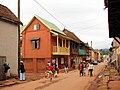 Ambalavao main street
 -
 Ambalavao main street
 -
 Landscape between Ambalavao & Talata Ampano


References edit
- ^ The Commune Census of by the Ilo program of Cornell University in collaboration with FOFIFA and INSTAT
- ^ Atlas Mondial, France Loisir, page 159
- ^ https://www.colonialarchitectureproject.org/picture?/98246/categories
- ^ https://www.colonialarchitectureproject.org/picture?/98144/categories
- ^ Carambole éditions: Guide de la Route nationale 7, p. 30
- ^ Carambole éditions: Guide de la Route nationale 7, p. 31
- ^ "Climate:Ambalavao". Climate-Data.org. Retrieved 11 April 2014.