
KNOWPIA
WELCOME TO KNOWPIA

Ambatofinandrahana 
Summary
Ambatofinandrahana is a municipality in Ambatofinandrahana District in central Madagascar.
Ambatofinandrahana | |
|---|---|
 Ambatofinandrahana Location in Madagascar | |
| Coordinates: 20°33′0″S 46°48′0″E / 20.55000°S 46.80000°E | |
| Country | |
| District | Ambatofinandrahana District |
| Region | Amoron'i Mania |
| Population (2018 census) | |
| • Total | 37,409 |
| Postal code | 304 |
| Climate | Cwb |
It is a part of Amoron'i Mania region. The population was 37,409 at the 2018 census.[1]
Geography edit
This town lies at the Route nationale 35 from Morondava to Ivato at 67 km from Ivato.
Nature edit
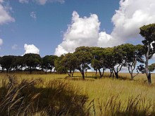
The protected area of the Massif d'Itremo.
The Tapia forest of Ambatofinandrahana supplies the town with fruits, champignons and wild silk.[2]
Geology edit

The only quartzite and marble quarries of Madagascar are found within 40km from this town and there are found 7 qualities: green, pink, brown, cream, blue pastel, white and black.[3]
References edit
20°33′S 46°48′E / 20.550°S 46.800°E