


Summary
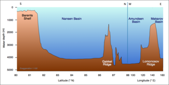
The Amundsen Basin, with depths up to 4.4 km (2.7 mi), is the deepest abyssal plain in the Arctic Ocean, and contains the geographic North Pole. The Amundsen Basin is embraced by the Lomonosov Ridge (from 81°N 140°E / 81°N 140°E to 80°N 40°W / 80°N 40°W) and the Gakkel Ridge (from 81°N 120°E / 81°N 120°E to 85°N 10°E / 85°N 10°E). It is named after the polar researcher Roald Amundsen. Together with the Nansen Basin, the Amundsen Basin is often summarized as Eurasian Basin.
The Russian-American cooperation Nansen and Amundsen Basin Observational System (NABOS) aims "to provide a quantitative observationally based assessment of circulation, water mass transformations, and transformation mechanisms in the Eurasian and Canadian Basins of the Arctic Ocean".
Formation edit
The Amundsen Basin formed during the Cenozoic Era from seafloor spreading.[1]
See also edit
References edit