


Summary
Anais (French pronunciation: [anɛ]) is a commune in the Charente-Maritime department in the Nouvelle-Aquitaine region of southwestern France.
Anais | |
|---|---|
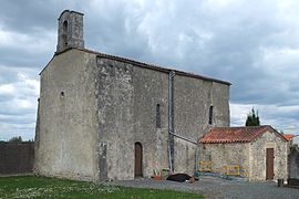 The church in Anais | |
Location of Anais .mw-parser-output .locmap .od{position:absolute}.mw-parser-output .locmap .id{position:absolute;line-height:0}.mw-parser-output .locmap .l0{font-size:0;position:absolute}.mw-parser-output .locmap .pv{line-height:110%;position:absolute;text-align:center}.mw-parser-output .locmap .pl{line-height:110%;position:absolute;top:-0.75em;text-align:right}.mw-parser-output .locmap .pr{line-height:110%;position:absolute;top:-0.75em;text-align:left}.mw-parser-output .locmap .pv>div{display:inline;padding:1px}.mw-parser-output .locmap .pl>div{display:inline;padding:1px;float:right}.mw-parser-output .locmap .pr>div{display:inline;padding:1px;float:left}html.skin-theme-clientpref-night .mw-parser-output .od,html.skin-theme-clientpref-night .mw-parser-output .od .pv>div,html.skin-theme-clientpref-night .mw-parser-output .od .pl>div,html.skin-theme-clientpref-night .mw-parser-output .od .pr>div{background:#000;color:#fff}html.skin-theme-clientpref-night .mw-parser-output .locmap{filter:grayscale(0.6)}@media(prefers-color-scheme:dark){html.skin-theme-clientpref-os .mw-parser-output .locmap{filter:grayscale(0.6)}html.skin-theme-clientpref-os .mw-parser-output .od,html.skin-theme-clientpref-os .mw-parser-output .od .pv>div,html.skin-theme-clientpref-os .mw-parser-output .od .pl>div,html.skin-theme-clientpref-os .mw-parser-output .od .pr>div{background:#000;color:#fff}}  Anais  Anais | |
| Coordinates: 46°11′16″N 0°54′26″W / 46.1878°N 0.9072°W | |
| Country | France |
| Region | Nouvelle-Aquitaine |
| Department | Charente-Maritime |
| Arrondissement | Rochefort |
| Canton | La Jarrie |
| Intercommunality | Aunis Sud |
| Government | |
| • Mayor (2020–2026) | Hervé Gaildrat[1] |
| Area 1 | 9.44 km2 (3.64 sq mi) |
| Population (2021)[2] | 316 |
| • Density | 33/km2 (87/sq mi) |
| Time zone | UTC+01:00 (CET) |
| • Summer (DST) | UTC+02:00 (CEST) |
| INSEE/Postal code | 17007 /17540 |
| Elevation | 3–29 m (9.8–95.1 ft) (avg. 16 m or 52 ft) |
| 1 French Land Register data, which excludes lakes, ponds, glaciers > 1 km2 (0.386 sq mi or 247 acres) and river estuaries. | |
Geography edit
Anais is located some 15 km east of La Rochelle and 5 km south by south-east of Nuaille-d'Aunis. It can be accessed by the D107 road from Dompierre-sur-Mer in the west passing through the centre of the commune south of the village and continuing to Bouhet. The D113 road also comes from Virson in the south passing through the southern part of the commune and continuing north-east to Le Gué-d'Alleré. Access to the village in the north of the commune is only by small country roads running off the D107 and the D113. Apart from the small village of Anais there is also a larger village called Les Grandes-Rivieres located on the D113 road.
The Curé stream forms the eastern boundary of the commune and the Virson forms the northern part of the western boundary and they both meet at a place called le Gouffre (the Pit) which is the start of the Canal du Curé on the municipal boundary of the neighbouring commune of Angliers.[3]
The small village of Anais is built on a low limestone hill, at an altitude of about 13 metres, and it is surrounded by numerous marshes, being located in the southern part of the Marais Poitevin which belongs geographically and historically the plain of Aunis.
It is in this part of the Marais Poitevin that the course of the Curé enters the vast marshy bowl after leaving the last calcareous soils of Aunis in the neighbouring commune of Bouhet.
Neighbouring communes and villages edit
Administration edit
This list is incomplete; you can help by adding missing items. (April 2021) |
List of Successive Mayors[4]
| From | To | Name | Party | Position |
|---|---|---|---|---|
| 2001 | 2014 | Gérard Grelier | SE | Retired |
| 2014 | 2020 | Bruno Gautronneau | DVG | |
| 2020 | 2026 | Hervé Gaildrat |
Population edit
The inhabitants of the commune are known as Anaisiens or Anaisiennes in French.[5]
| Year | Pop. | ±% p.a. |
|---|---|---|
| 1968 | 197 | — |
| 1975 | 195 | −0.15% |
| 1982 | 211 | +1.13% |
| 1990 | 231 | +1.14% |
| 1999 | 210 | −1.05% |
| 2007 | 284 | +3.85% |
| 2012 | 326 | +2.80% |
| 2017 | 320 | −0.37% |
| Source: INSEE[6] | ||
Distribution of Age Groups edit
The population of the commune is younger than the departmental average.
Percentage Distribution of Age Groups in Anais and Charente-Maritime Department in 2017
| Anais | Charente-Maritime | |||
|---|---|---|---|---|
| Age Range | Men | Women | Men | Women |
| 0 to 14 Years | 16.8 | 19.7 | 16.3 | 14.3 |
| 15 to 29 Years | 13.0 | 13.2 | 15.4 | 13.1 |
| 30 to 44 Years | 16.8 | 22.4 | 16.7 | 16.1 |
| 45 to 59 Years | 29.8 | 23.0 | 20.2 | 19.9 |
| 60 to 74 Years | 17.4 | 17.8 | 21.1 | 22.0 |
| 75 to 89 Years | 6.2 | 3.9 | 9.4 | 12.3 |
| 90 Years+ | 0.0 | 0.0 | 1.0 | 2.4 |
Sites and Monuments edit
- The Church of Saint Peter from the 10th century.
Transport edit
Nearest Railway Stations and Halts edit
- Surgères (TGV) 14 km
- Mer 17.8 km
- Aytré (halt) 18.1 km
- Mauzé-sur-le-Mignon (halt) 18.2 km
- Châtelaillon 18.5 km
Nearest Airport and aerodromes edit
- La Rochelle (Laleu) 22.1 km
- Rochefort-Saint-Agnant 33.8 km
- Niort-Souché 41.4 km
See also edit
References edit
- ^ "Répertoire national des élus: les maires". data.gouv.fr, Plateforme ouverte des données publiques françaises (in French). 2 December 2020.
- ^ "Populations légales 2021". The National Institute of Statistics and Economic Studies. 28 December 2023.
- ^ a b Google Maps
- ^ List of Mayors of France
- ^ Le nom des habitants du 17 - Charente-Maritime, habitants.fr
- ^ a b Évolution et structure de la population en 2017: Commune d'Anais (17007)
- ^ Évolution et structure de la population en 2017: Département de la Charente-Maritime (17)
External links edit
- Anais on the National Geographic Institute website (in French)
- Anais on Géoportail, National Geographic Institute (IGN) website (in French)
- Ancix on the 1750 Cassini Map