


Summary
Angat, officially the Municipality of Angat (Tagalog: Bayan ng Angat), is a 1st class municipality in the province of Bulacan, Philippines. According to the 2020 census, it has a population of 65,617 people.[3]
Angat | |
|---|---|
| Municipality of Angat | |
 Municipal Hall | |
 Flag  Seal | |
| Nickname: True Heart of Bulacan | |
 Map of Bulacan with Angat highlighted | |
OpenStreetMap .mw-parser-output .locmap .od{position:absolute}.mw-parser-output .locmap .id{position:absolute;line-height:0}.mw-parser-output .locmap .l0{font-size:0;position:absolute}.mw-parser-output .locmap .pv{line-height:110%;position:absolute;text-align:center}.mw-parser-output .locmap .pl{line-height:110%;position:absolute;top:-0.75em;text-align:right}.mw-parser-output .locmap .pr{line-height:110%;position:absolute;top:-0.75em;text-align:left}.mw-parser-output .locmap .pv>div{display:inline;padding:1px}.mw-parser-output .locmap .pl>div{display:inline;padding:1px;float:right}.mw-parser-output .locmap .pr>div{display:inline;padding:1px;float:left}html.skin-theme-clientpref-night .mw-parser-output .od,html.skin-theme-clientpref-night .mw-parser-output .od .pv>div,html.skin-theme-clientpref-night .mw-parser-output .od .pl>div,html.skin-theme-clientpref-night .mw-parser-output .od .pr>div{background:#000;color:#fff}html.skin-theme-clientpref-night .mw-parser-output .locmap{filter:grayscale(0.6)}@media(prefers-color-scheme:dark){html.skin-theme-clientpref-os .mw-parser-output .locmap{filter:grayscale(0.6)}html.skin-theme-clientpref-os .mw-parser-output .od,html.skin-theme-clientpref-os .mw-parser-output .od .pv>div,html.skin-theme-clientpref-os .mw-parser-output .od .pl>div,html.skin-theme-clientpref-os .mw-parser-output .od .pr>div{background:#000;color:#fff}}  Angat Location within the Philippines | |
| Coordinates: 14°55′41″N 121°01′46″E / 14.928147°N 121.029319°E | |
| Country | Philippines |
| Region | Central Luzon |
| Province | Bulacan |
| District | 6th district |
| Founded | 1683 |
| Barangays | 16 (see Barangays) |
| Government | |
| • Type | Sangguniang Bayan |
| • Mayor | Reynante S. Bautista |
| • Vice Mayor | Arvin L. Agustin |
| • Representative | Salvador A. Pleyto Sr. |
| • Municipal Council | Members |
| • Electorate | 42,236 voters (2022) |
| Area | |
| • Total | 74.00 km2 (28.57 sq mi) |
| Elevation | 59 m (194 ft) |
| Highest elevation | 157 m (515 ft) |
| Lowest elevation | 20 m (70 ft) |
| Population (2020 census)[3] | |
| • Total | 65,617 |
| • Density | 890/km2 (2,300/sq mi) |
| • Households | 16,554 |
| Economy | |
| • Income class | 1st municipal income class |
| • Poverty incidence | 4.61 |
| • Revenue | ₱ 231.7 million (2020) |
| • Assets | ₱ 385.3 million (2020) |
| • Expenditure | ₱ 231.7 million (2020) |
| • Liabilities | ₱ 120.3 million (2020) |
| Service provider | |
| • Electricity | Manila Electric Company (Meralco) |
| Time zone | UTC+8 (PST) |
| ZIP code | 3012 |
| PSGC | 031401000 |
| IDD : area code | +63 (0)44 |
| Native languages | Tagalog |
| Website | www |
Etymology edit
The town got its name after the Tagalog word Angat (A-ngat), meaning elevated or a high piece of land.
History edit
Angat was originally a part of the Old Pueblo de Quingua, now Municipality of Plaridel. This fact was due most probably to the situation of the Rio de Quingua Angat River, which directly connects the town of Quingua, a community then located in the center of vast lands, covering plains and mountains alike.
Augustinian missionaries built a small visita (chapel) under the Parochial ministry of Paroquia de Santiago Matamoro de Quingua. In 1683 the visita of Angat made a Town Church and the whole Angat where established as a new Pueblo.
Today, still stands and legible, is the inscription at the façade of her church with a Roman Numeral "MDCCXII" translated to "1727" a year indicating the date of the erection the Angat Church's present building.
Geography edit
The towns of San Rafael, Bulacan and Bustos, Bulacan bound the town of Angat on the North. On the East by the vast Sierra Madre Mountain Ranges - Sierra Madre (Philippines), to its South by the towns of Norzagaray, Bulacan and Santa Maria, Bulacan. Angat is 44 kilometres (27 mi) from Malolos and 51 kilometres (32 mi) from Manila.
The municipality of Angat has hilly and mountainous landscape that nestles Angat River - (Bulacan River) which snakes around eleven provinces in the Central Luzon Region. Angat River's main basin of water resource is from Sierra Madre Mountain Range (the longest mountain range in the Philippines) in Luzon island. During increment climate condition like continuous rainy days for days the water inundates to different river tributaries in its adjoining municipalities, as well as provinces through different rivers. To the southeast are 2 rivers: Santa Maria River of Santa Maria, Bulacan. Bunsuran River of Pandi, Bulacan. Balagtas River of Balagtas, Bulacan, and Bocaue River of Bocaue, Bulacan.
Angat's mountainous and hilly area has abundance of trees that are source of timber and wood materials, and unfortunately become an area of illegal logging. The mountainous areas, and lands close to the river shore, some of which are privately owned is rich in mineral deposit of silica. The vast area around Angat River is very high source of rocks and pebbles used for construction and garden landscaping.
Most areas have a very relaxing atmosphere of greenery seen in mountain heights and river shore lines where some fresh water fishes also multiplies. Angat was once part of the 3rd district along with Norzagaray from 1987 to 2022 when it was moved to 6th district along with Santa Maria and Norzagaray.
Barangays edit
Angat is subdivided into 16 barangays. Each barangay consists of puroks and some have sitios.
| PSGC | Barangay | Population | ±% p.a. | |||
|---|---|---|---|---|---|---|
| 2020[3] | 2010[5] | |||||
| 031401001 | Banaban | 3.3% | 2,140 | 1,539 | 3.35% | |
| 031401002 | Baybay | 1.3% | 855 | 836 | 0.22% | |
| 031401003 | Binagbag | 7.9% | 5,182 | 4,641 | 1.11% | |
| 031401005 | Donacion | 4.0% | 2,603 | 2,502 | 0.40% | |
| 031401006 | Encanto | 7.1% | 4,665 | 4,289 | 0.84% | |
| 031401007 | Laog | 1.9% | 1,225 | 1,053 | 1.52% | |
| 031401008 | Marungko | 6.6% | 4,344 | 4,263 | 0.19% | |
| 031401009 | Niugan | 7.0% | 4,607 | 4,362 | 0.55% | |
| 031401010 | Paltok | 2.2% | 1,447 | 1,369 | 0.56% | |
| 031401013 | Pulong Yantok | 7.5% | 4,940 | 3,990 | 2.16% | |
| 031401014 | San Roque (Poblacion) | 7.9% | 5,168 | 4,642 | 1.08% | |
| 031401015 | Santa Cruz (Poblacion) | 8.6% | 5,641 | 5,663 | −0.04% | |
| 031401016 | Santa Lucia | 3.8% | 2,475 | 2,663 | −0.73% | |
| 031401017 | Santo Cristo (Poblacion) | 7.6% | 4,999 | 4,859 | 0.28% | |
| 031401018 | Sulucan | 8.7% | 5,723 | 5,557 | 0.29% | |
| 031401019 | Taboc | 4.9% | 3,223 | 3,104 | 0.38% | |
| Total | 65,617 | 55,332 | 1.72% | |||
Climate edit
The prevailing climatic conditions in the municipality is categorized into two (2) types: Wet season (Rainy Season or Monsoon Season) and Dry Season (Summer Season).
| Climate data for Angat, Bulacan | |||||||||||||
|---|---|---|---|---|---|---|---|---|---|---|---|---|---|
| Month | Jan | Feb | Mar | Apr | May | Jun | Jul | Aug | Sep | Oct | Nov | Dec | Year |
| Mean daily maximum °C (°F) | 29 (84) |
31 (88) |
32 (90) |
34 (93) |
34 (93) |
31 (88) |
30 (86) |
30 (86) |
30 (86) |
30 (86) |
30 (86) |
29 (84) |
30 (86) |
| Mean daily minimum °C (°F) | 20 (68) |
19 (66) |
21 (70) |
22 (72) |
23 (73) |
23 (73) |
23 (73) |
23 (73) |
23 (73) |
22 (72) |
21 (70) |
20 (68) |
21 (70) |
| Average precipitation cm (inches) | 1.7 (0.7) |
0.7 (0.3) |
0.5 (0.2) |
2.4 (0.9) |
15.3 (6) |
35.5 (14) |
50.4 (19.8) |
51.6 (20.3) |
37.4 (14.7) |
22.5 (8.8) |
16.3 (6.4) |
6.8 (2.7) |
240.8 (94.8) |
| Source: http://www.weatherbase.com/weather/weather.php3?s=984300&refer=&units=metric | |||||||||||||
Demographics edit
| Year | Pop. | ±% p.a. |
|---|---|---|
| 1903 | 6,961 | — |
| 1918 | 9,019 | +1.74% |
| 1939 | 11,060 | +0.98% |
| 1948 | 12,776 | +1.62% |
| 1960 | 15,051 | +1.37% |
| 1970 | 19,798 | +2.78% |
| 1975 | 23,344 | +3.36% |
| 1980 | 24,844 | +1.25% |
| 1990 | 34,494 | +3.34% |
| 1995 | 39,037 | +2.35% |
| 2000 | 46,033 | +3.60% |
| 2007 | 53,117 | +1.99% |
| 2010 | 55,332 | +1.50% |
| 2015 | 59,237 | +1.31% |
| 2020 | 65,617 | +2.03% |
| Source: Philippine Statistics Authority[6][5][7][8] | ||
In the 2020 census, the population of Angat, Bulacan, was 65,617 people,[3] with a density of 890 inhabitants per square kilometre or 2,300 inhabitants per square mile.
Religion edit

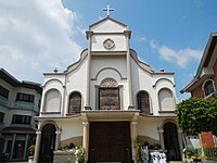
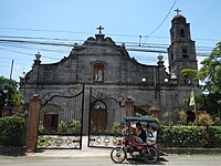
The people of Angat are mostly devout Roman Catholics. Their patron saint is Saint Monica. The Santa Monica de Angat Church displays baroque architecture, with its interior replicating the Sistine Chapel, recently remodeled but preserving its old architecture. In 1983, the Parish of the town celebrated its Tricentennial Foundation.
Today, Angat is divided into three parishes and one quasi-parish under the Vicariate of Baliuag, Roman Catholic Diocese of Malolos: 1. the Saint Paul the Apostle Parish in Barangay Niugan; 2. the Santa Rita de Cascia Parish in Barangay Binagbag; 3. Santa Monica de Angat Parish in Poblacion and 4. Immaculate Conception Quasi-Parish in Barangay Marungko.
Other religious groups include the Members Church of God International popularly known as Ang Dating Daan, Iglesia ni Cristo, and Jehovah's Witness, Methodists, Aglipayans, Adventists, Baptists, Mormons. There also some Evangelical, Pentecostal, Charismatic churches, ministries, fellowships and religious groups. Islam (Muslims) could also be found.
Economy edit
Government edit
Elected officials edit
| Position | Name | Party | |
|---|---|---|---|
| Mayor | Reynante "Jowar" S. Bautista | Aksyon | |
| Vice Mayor | Arvin L. Agustin | Aksyon | |
| Councilors | Oscar "Oca" C. Suarez | Aksyon | |
| William S. Vergel de Dios | Aksyon | ||
| Evelyn "Blem" J. Cruz | Aksyon | ||
| Luis "Wowie" J. Santiago | Aksyon | ||
| Melandro "Andro" G. Tigas | Aksyon | ||
| Darwin A. Calderon | Aksyon | ||
| Erwin S. Santos | NUP | ||
| Ramiro A. Osorio III | Independent | ||
| Ex Officio Municipal Council Members | |||
| ABC President | Richard C. Cruz | Nonpartisan | |
| SK Federation President | Cyndi Pearl Valencia | Nonpartisan | |
List of former mayors edit
| No. | Municipal Mayors | Took office | Left office |
|---|---|---|---|
| 1 | Mariano Santiago | 1901 | 1902 |
| 2 | Pedro Otayco | 1902 | 1903 |
| 3 | Francisco Vergel de Dios | 1903 | 1904 |
| 4 | Damian Santos | 1904 | 1905 |
| 5 | Damaso Pascual | 1905 | 1906 |
| 6 | Luciano de Guzman | 1906 | 1909 |
| 7 | Pablo Capistrano | 1909 | 1916 |
| 8 | Matias A. Fernando | 1916 | 1920 |
| 9 | Severo Rivera | 1920 | 1922 |
| 10 | Gerardo Santos | 1922 | 1925 |
| 11 | Atilano de Guzman | 1925 | 1931 |
| 12 | Dr. Crispulo Cruz | 1931 | 1934 |
| 13 | Pablo Amisola | 1934 | 1940 |
| 14 | Dr. Francisco Infantado | 1940 | 1940 |
| 15 | Jose S. Santos | 1940 | 1942 |
| 16 | Felix Ventura | 1942 | 1943 |
| 17 | Dr. Pedro Vergel de Dios | 1943 | 1943 |
| 18 | Atilano de Guzman | 1943 | 1943 |
| 19 | Engr. Vicente Salvador | 1943 | 1943 |
| 20 | Dr. Marcelino de Guzman | 1943 | 1944 |
| 21 | Pedro Cinco | 1944 | 1944 |
| 22 | Agapito Cruz Correa | 1944 | 1944 |
| 23 | Atty. Pablo Santos | 1944 | 1945 |
| 24 | Dr. Luis Infantado | 1945 | 1945 |
| 25 | Higino Adriano | 1945 | 1946 |
| 26 | Jose S. Santos | 1946 | 1947 |
| 27 | Atilano de Guzman | 1947 | 1947 |
| 28 | Faustino Sombillo | 1947 | 1948 |
| 29 | Francisco F. Illescas | 1948 | 1954 |
| 30 | Benito Cruz | 1954 | 1963 |
| 31 | Francisco Illescas | 1964 | 1980 |
| 32 | Atty. Florante Cruz | 1980 | 1986 |
| 33 | Francisca C. Valarao | 1986 | 6 months |
| 34 | Leonardo R. de Leon | 1987 | 1998 |
| 35 | Apolonio P. Marcelo Jr. | 1998 | 2000 |
| 36 | Angelito Vergel de Dios | 2000 | 2001 |
| 37 | Leonardo R. de Leon | 2001 | 2010 |
| 38 | Gilberto C. Santos | 2010 | 2013 |
| 39 | Leonardo R. de Leon | 2013 | 2022 |
| 40 | Reynante S. Bautista | 2022 | present |
Education edit
Colegio de Sta Monica de Angat edit
The Angateños consider education as very important. It was the dream of many that there would be a Catholic school in Angat. This dream was realized in 1983 through the initiative and leadership of the founding members of the first Board of Trustees of Santa Monica Catholic School, Inc.: Bishop Cirilio R. Almario, Jr., Rev. Fr. Macario R. Manahan, Councilor Manuel C. De Guzman, Mrs. Angelita A. Cruz, Mr. Francisco C. Robles.
Through a memorandum of agreement between the Ministry of Social Services and Development and the Parents' Committee, the Day Care Center became Santa Monica Catholic Learning Center. In 1985, the school was renamed Santa Monica Catholic School and given the permit to open and conduct Grade VI. The first batch of Grade VI graduates received their diplomas in March 1986.
On March 27, 1987, the high school department was formally opened. A year later, the school's name was changed to Colegio de Santa Monica de Angat to reflect the town's Hispanic heritage. In the same year, the St. Joseph Building was inaugurated. The first batch graduated in March 1990. Today, the school's population and physical structure continues to grow.[16]
Other schools edit
| School | Location |
|---|---|
| Angat Ecumenical Kindergarten School | Santa Cruz |
| Colegio De Santa Monica De Angat | Poblacion |
| Kalinangan Integrated School | Sulucan |
| Lourdes School Of Bulacan | Marungko |
| Wisdom Jade Academy | Niugan |
| School | Location |
|---|---|
| Atiliano S. De Guzman Elementary School | Taboc |
| Pablo C. Capistrano Elementary School | Banaban |
| Baybay Elementary School | Baybay |
| Benito C. Cruz Elementary School | Santa Lucia |
| Col. Vicente Salvador Elementary School | Laog |
| Don Pablo Amisola Memorial School | Niugan |
| Dr. Antonio C. Villarama Memorial School | Marungko |
| Francisco F. Illescas Elementary School | Binagbag |
| Marcelo L. Adriano Memorial School | Encanto |
| Matias A. Fernando Memorial School | San Roque |
| Osias M. Esteban Elementary School | Pulong Yantok |
| Paltoc Elementary School | Paltoc |
| Sulucan Elementary School | Sulucan |
| Teodoso R. Manuel Elementary School | Donacion |
| School | Location |
|---|---|
| Colegio De Santa Monica De Angat | Poblacion |
| Franklin Delano Roosevelt Memorial School | Santo Cristo |
| Kalinangan Integrated School | Sulucan |
| Lourdes School of Bulacan | Marungko |
| School | Location |
|---|---|
| Angat National High School | Taboc |
| Angel M. del Rosario Memorial High School | Pulong Yantok |
| Binagbag National High School | Binagbag |
| Pres. Diosdado P. Macapagal Memorial High School | Santa Cruz |
| School | Location |
|---|---|
| Bulacan Polytechnic College | Santa Cruz |
| School | Location |
|---|---|
| Lourdes College of Bulacan | Marungko |
Culture and Tourism edit
Town festivities and events edit
As a predominantly Roman Catholic Christian community, every barangay has their own unique way of celebrating fiestas in honor of their respective patron saint. In the town proper where the old beautiful church of Angat is located, the locals celebrate their fiesta every 4 May in honor of its patron St. Monica, mother of St. Augustine.
Angat is celebrating GulayAngat Festival (Gunita ng Lahi at Yamanag Angat; lit., "Angat Heritage and Treasure Festival") which features the means of livelihood of the town's people. It is celebrated every 3rd week of the month of October. It was accompanied by the establishment of the town of Angat. There were lot of activities happened in the festival such as:
- Hari at Reyna ng GulayAngat (King and Queen of GulayAngat) – featuring the beautiful young men and women of each barangay in Angat.
- Hapag ng Pamana (Heritage Table) – presenting unique dishes made from vegetables.
- Indakan sa GulayAngat (GulayAngat Dance) – highlighting the talent of everyone in their respective barangays through dancing.
- DepEd Day – featuring the talents of the students in Angat.
- Laro ng Laking GulayAngat (GulayAngat Traditional Games) – presenting the different Filipino games just like; Hilahang Lubid (tug-of-war), Karera ng Sako (sack race), Patintero, Palo Sebo (bamboo pole climbing), Dama, Sungka, Agawang Buko (a contact game which players struggle to get a coconut similar to rugby and American football) and Sepak Takraw.
Tourist attractions edit
- Angat River
- Heritage Houses
- Santa Monica Church (Santa Monica de Angat Church)
- Gawad Kalinga (Enchanted Farm)
- Fr. Blanco Museum (collection of flora de filipina)
Gallery edit
-
 Angat Welcome Arch
 -
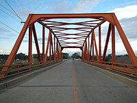 Santa Lucia Bridge (crossing the Angat River from the Municipality of Angat to the Municipality of Doña Remedios Trinidad)
 -
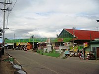 Angat Wet and Dry Public Market
 -
 Villarama Park at Dr. Antonio C. Villarama Memorial School
 -
 San Pablo Apostol Parish Church
 -
 Santa Rita de Cascia Quasi-Parish Church
 -
 St. Joseph Sub-Parish Church
 -
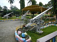
 Veterans Federation of the Philippines marker for the World War II Veterans - Angat Chapter
 -
 Overlooking view of Angat quarry and Sierra Madre (Philippines)
 -
 Angat River from overlooking view


References edit
- ^ Municipality of Angat | (DILG)
- ^ "2015 Census of Population, Report No. 3 – Population, Land Area, and Population Density" (PDF). Philippine Statistics Authority. Quezon City, Philippines. August 2016. ISSN 0117-1453. Archived (PDF) from the original on May 25, 2021. Retrieved July 16, 2021.
- ^ a b c d Census of Population (2020). "Region III (Central Luzon)". Total Population by Province, City, Municipality and Barangay. Philippine Statistics Authority. Retrieved 8 July 2021.
- ^ "PSA Releases the 2018 Municipal and City Level Poverty Estimates". Philippine Statistics Authority. 15 December 2021. Retrieved 22 January 2022.
- ^ a b Census of Population and Housing (2010). "Region III (Central Luzon)" (PDF). Total Population by Province, City, Municipality and Barangay. National Statistics Office. Retrieved 29 June 2016.
- ^ Census of Population (2015). "Region III (Central Luzon)". Total Population by Province, City, Municipality and Barangay. Philippine Statistics Authority. Retrieved 20 June 2016.
- ^ Censuses of Population (1903–2007). "Region III (Central Luzon)". Table 1. Population Enumerated in Various Censuses by Province/Highly Urbanized City: 1903 to 2007. National Statistics Office.
{{cite encyclopedia}}: CS1 maint: numeric names: authors list (link) - ^ "Province of Bulacan". Municipality Population Data. Local Water Utilities Administration Research Division. Retrieved 17 December 2016.
- ^ "Poverty incidence (PI):". Philippine Statistics Authority. Retrieved December 28, 2020.
- ^ "Estimation of Local Poverty in the Philippines" (PDF). Philippine Statistics Authority. 29 November 2005.
- ^ "2003 City and Municipal Level Poverty Estimates" (PDF). Philippine Statistics Authority. 23 March 2009.
- ^ "City and Municipal Level Poverty Estimates; 2006 and 2009" (PDF). Philippine Statistics Authority. 3 August 2012.
- ^ "2012 Municipal and City Level Poverty Estimates" (PDF). Philippine Statistics Authority. 31 May 2016.
- ^ "Municipal and City Level Small Area Poverty Estimates; 2009, 2012 and 2015". Philippine Statistics Authority. 10 July 2019.
- ^ "PSA Releases the 2018 Municipal and City Level Poverty Estimates". Philippine Statistics Authority. 15 December 2021. Retrieved 22 January 2022.
- ^ Reference 6
- ^ "Schools & Utility Services". Municipality of Angat. Archived from the original on 2015-04-03. Retrieved 2015-04-02.
External links edit
- Philippine Standard Geographic Code
- Philippine Census Information
- Angat Bulacan
- Angat, Bulacan at WN
- Angat.NET Our town, Our Home
- [1]