


Summary
Angoville-au-Plain (French pronunciation: [ɑ̃ɡɔvil o plɛ̃]) is a former commune in the Manche department in the Normandy region in northwestern France. On 1 January 2016, it was merged into the new commune of Carentan-les-Marais.[2] It was one of the least populated communes in Manche.
Angoville-au-Plain | |
|---|---|
Part of Carentan-les-Marais | |
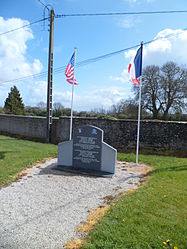 101st Airborne monument | |
Location of Angoville-au-Plain .mw-parser-output .locmap .od{position:absolute}.mw-parser-output .locmap .id{position:absolute;line-height:0}.mw-parser-output .locmap .l0{font-size:0;position:absolute}.mw-parser-output .locmap .pv{line-height:110%;position:absolute;text-align:center}.mw-parser-output .locmap .pl{line-height:110%;position:absolute;top:-0.75em;text-align:right}.mw-parser-output .locmap .pr{line-height:110%;position:absolute;top:-0.75em;text-align:left}.mw-parser-output .locmap .pv>div{display:inline;padding:1px}.mw-parser-output .locmap .pl>div{display:inline;padding:1px;float:right}.mw-parser-output .locmap .pr>div{display:inline;padding:1px;float:left}html.skin-theme-clientpref-night .mw-parser-output .od,html.skin-theme-clientpref-night .mw-parser-output .od .pv>div,html.skin-theme-clientpref-night .mw-parser-output .od .pl>div,html.skin-theme-clientpref-night .mw-parser-output .od .pr>div{background:#fff;color:#000}html.skin-theme-clientpref-night .mw-parser-output .locmap{filter:grayscale(0.6)}@media(prefers-color-scheme:dark){html.skin-theme-clientpref-os .mw-parser-output .locmap{filter:grayscale(0.6)}html.skin-theme-clientpref-os .mw-parser-output .od,html.skin-theme-clientpref-os .mw-parser-output .od .pv>div,html.skin-theme-clientpref-os .mw-parser-output .od .pl>div,html.skin-theme-clientpref-os .mw-parser-output .od .pr>div{background:white;color:#000}}  Angoville-au-Plain  Angoville-au-Plain | |
| Coordinates: 49°20′57″N 1°15′10″W / 49.3492°N 1.2528°W | |
| Country | France |
| Region | Normandy |
| Department | Manche |
| Arrondissement | Saint-Lô |
| Canton | Carentan |
| Commune | Carentan-les-Marais |
| Area 1 | 5.68 km2 (2.19 sq mi) |
| Population (2019)[1] | 100 |
| • Density | 18/km2 (46/sq mi) |
| Time zone | UTC+01:00 (CET) |
| • Summer (DST) | UTC+02:00 (CEST) |
| Postal code | 50480 |
| Elevation | 2–32 m (6.6–105.0 ft) (avg. 12 m or 39 ft) |
| 1 French Land Register data, which excludes lakes, ponds, glaciers > 1 km2 (0.386 sq mi or 247 acres) and river estuaries. | |
It is home to a church that was used by 2 US Army Medics as an aide station during the Battle of Normandy in World War II. Robert Wright and Ken Moore of the 101st Airborne treated a mix of 80 injured American and German wounded soldiers and a child. Blood stains are still visible on the pews. Two stained glass windows commemorate the 101st Airborne Division, the first one is dedicated to the two medics of the 2nd Battalion of the 501st Parachute Infantry Regiment (101st Airborne Division). The second one honoured the American parachutists.

Population edit
|
|
Gallery edit
-
 Stained glass window in church at Angoville-au-Plain, France.
 -
 Stained glass window in church at Angoville-au-Plain, France.


See also edit
References edit
External links edit
- Normandy Then and Now in Angoville-au-Plain