
KNOWPIA
WELCOME TO KNOWPIA

Angres 
Summary
Angres (French pronunciation: [ɑ̃ɡʁ]) is a commune in the Pas-de-Calais department in the Hauts-de-France region of France.[3]
Angres | |
|---|---|
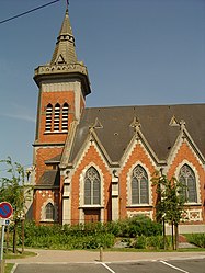 The church of Angres | |
 Coat of arms | |
Location of Angres .mw-parser-output .locmap .od{position:absolute}.mw-parser-output .locmap .id{position:absolute;line-height:0}.mw-parser-output .locmap .l0{font-size:0;position:absolute}.mw-parser-output .locmap .pv{line-height:110%;position:absolute;text-align:center}.mw-parser-output .locmap .pl{line-height:110%;position:absolute;top:-0.75em;text-align:right}.mw-parser-output .locmap .pr{line-height:110%;position:absolute;top:-0.75em;text-align:left}.mw-parser-output .locmap .pv>div{display:inline;padding:1px}.mw-parser-output .locmap .pl>div{display:inline;padding:1px;float:right}.mw-parser-output .locmap .pr>div{display:inline;padding:1px;float:left}html.skin-theme-clientpref-night .mw-parser-output .od,html.skin-theme-clientpref-night .mw-parser-output .od .pv>div,html.skin-theme-clientpref-night .mw-parser-output .od .pl>div,html.skin-theme-clientpref-night .mw-parser-output .od .pr>div{background:#000;color:#fff}html.skin-theme-clientpref-night .mw-parser-output .locmap{filter:grayscale(0.6)}@media(prefers-color-scheme:dark){html.skin-theme-clientpref-os .mw-parser-output .locmap{filter:grayscale(0.6)}html.skin-theme-clientpref-os .mw-parser-output .od,html.skin-theme-clientpref-os .mw-parser-output .od .pv>div,html.skin-theme-clientpref-os .mw-parser-output .od .pl>div,html.skin-theme-clientpref-os .mw-parser-output .od .pr>div{background:#000;color:#fff}}  Angres  Angres | |
| Coordinates: 50°24′35″N 2°45′33″E / 50.4097°N 2.7592°E | |
| Country | France |
| Region | Hauts-de-France |
| Department | Pas-de-Calais |
| Arrondissement | Lens |
| Canton | Bully-les-Mines |
| Intercommunality | Communaupole de Lens-Liévin |
| Government | |
| • Mayor (2023–2026) | Anouck Breton[1] |
| Area 1 | 4.82 km2 (1.86 sq mi) |
| Population (2021)[2] | 4,842 |
| • Density | 1,000/km2 (2,600/sq mi) |
| Time zone | UTC+01:00 (CET) |
| • Summer (DST) | UTC+02:00 (CEST) |
| INSEE/Postal code | 62032 /62143 |
| Elevation | 49–106 m (161–348 ft) (avg. 54 m or 177 ft) |
| 1 French Land Register data, which excludes lakes, ponds, glaciers > 1 km2 (0.386 sq mi or 247 acres) and river estuaries. | |
Geography edit
A farming and light industrial suburb situated just 3 miles (4.8 km) southwest of Lens centre, at the junction of the D51 and D58e roads. The A26 autoroute passes by, just within the borders of the commune.
Population edit
| Year | Pop. | ±% p.a. |
|---|---|---|
| 1968 | 4,384 | — |
| 1975 | 4,538 | +0.49% |
| 1982 | 4,239 | −0.97% |
| 1990 | 4,394 | +0.45% |
| 1999 | 4,469 | +0.19% |
| 2007 | 4,054 | −1.21% |
| 2012 | 4,067 | +0.06% |
| 2017 | 4,526 | +2.16% |
| Source: INSEE[4] | ||
Sights edit
- The church of St. Cyr, rebuilt, as was most of the village, after the First World War.
- The war memorials.
International relations edit
Angres is twinned with:
![]() Danderhall, Midlothian, Scotland.
Danderhall, Midlothian, Scotland.
See also edit
References edit
- ^ "Répertoire national des élus: les maires" (in French). data.gouv.fr, Plateforme ouverte des données publiques françaises. 6 June 2023.
- ^ "Populations légales 2021". The National Institute of Statistics and Economic Studies. 28 December 2023.
- ^ INSEE commune file
- ^ Population en historique depuis 1968, INSEE
External links edit
Wikimedia Commons has media related to Angres.
- Town council website (in French)
- Website of the Communaupole de Lens-Liévin (in French)