
KNOWPIA
WELCOME TO KNOWPIA

Anost 
Summary
Anost (French pronunciation: [ano]) is a rural commune in the Saône-et-Loire department in the Bourgogne-Franche-Comté region in central-east France.[3] It is located on the departmental border with Nièvre, northeast of the Haut-Folin summit and southwest of Ménessaire, a Côte-d'Or exclave.
Anost | |
|---|---|
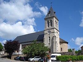 Église Saint-Germain | |
Location of Anost .mw-parser-output .locmap .od{position:absolute}.mw-parser-output .locmap .id{position:absolute;line-height:0}.mw-parser-output .locmap .l0{font-size:0;position:absolute}.mw-parser-output .locmap .pv{line-height:110%;position:absolute;text-align:center}.mw-parser-output .locmap .pl{line-height:110%;position:absolute;top:-0.75em;text-align:right}.mw-parser-output .locmap .pr{line-height:110%;position:absolute;top:-0.75em;text-align:left}.mw-parser-output .locmap .pv>div{display:inline;padding:1px}.mw-parser-output .locmap .pl>div{display:inline;padding:1px;float:right}.mw-parser-output .locmap .pr>div{display:inline;padding:1px;float:left}html.skin-theme-clientpref-night .mw-parser-output .od,html.skin-theme-clientpref-night .mw-parser-output .od .pv>div,html.skin-theme-clientpref-night .mw-parser-output .od .pl>div,html.skin-theme-clientpref-night .mw-parser-output .od .pr>div{background:#000;color:#fff}html.skin-theme-clientpref-night .mw-parser-output .locmap{filter:grayscale(0.6)}@media(prefers-color-scheme:dark){html.skin-theme-clientpref-os .mw-parser-output .locmap{filter:grayscale(0.6)}html.skin-theme-clientpref-os .mw-parser-output .od,html.skin-theme-clientpref-os .mw-parser-output .od .pv>div,html.skin-theme-clientpref-os .mw-parser-output .od .pl>div,html.skin-theme-clientpref-os .mw-parser-output .od .pr>div{background:#000;color:#fff}}  Anost  Anost | |
| Coordinates: 47°04′41″N 4°06′01″E / 47.0781°N 4.1003°E | |
| Country | France |
| Region | Bourgogne-Franche-Comté |
| Department | Saône-et-Loire |
| Arrondissement | Autun |
| Canton | Autun-1 |
| Intercommunality | CC du Grand Autunois Morvan |
| Government | |
| • Mayor (2020–2026) | Louis Basdevant[1] |
| Area 1 | 51.91 km2 (20.04 sq mi) |
| Population (2021)[2] | 710 |
| • Density | 14/km2 (35/sq mi) |
| Demonym | Anostiens |
| Time zone | UTC+01:00 (CET) |
| • Summer (DST) | UTC+02:00 (CEST) |
| INSEE/Postal code | 71009 /71550 |
| Elevation | 357–785 m (1,171–2,575 ft) (avg. 410 m or 1,350 ft) |
| Website | www.anost.fr |
| 1 French Land Register data, which excludes lakes, ponds, glaciers > 1 km2 (0.386 sq mi or 247 acres) and river estuaries. | |
Geography edit
The commune lies in the northwestern part of Saône-et-Loire, northwest of the subprefecture Autun. It is part of the Morvan natural area, as well as Morvan Regional Natural Park.
Demographics edit
| Year | Pop. | ±% p.a. |
|---|---|---|
| 1968 | 1,058 | — |
| 1975 | 867 | −2.80% |
| 1982 | 847 | −0.33% |
| 1990 | 746 | −1.57% |
| 1999 | 679 | −1.04% |
| 2009 | 691 | +0.18% |
| 2014 | 725 | +0.97% |
| 2020 | 714 | −0.25% |
| Source: INSEE[4] | ||
See also edit
References edit
- ^ "Répertoire national des élus: les maires". data.gouv.fr, Plateforme ouverte des données publiques françaises (in French). 2 December 2020.
- ^ "Populations légales 2021". The National Institute of Statistics and Economic Studies. 28 December 2023.
- ^ INSEE commune file
- ^ Population en historique depuis 1968, INSEE.
External links edit
Wikimedia Commons has media related to Anost.
- Official website