


Summary
Anticosti National Park (French (official): Parc National d'Anticosti) is a provincial park of Quebec, located in the Gulf of St. Lawrence.[1] It consists of 3 non-contiguous areas totalling 572 square kilometres (221 sq mi) of land in the centre of Anticosti Island. Portions of the park are within Anticosti World Heritage Site, established by UNESCO in 2023.
| Anticosti National Park | |
|---|---|
| Parc National d'Anticosti | |
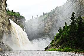 Vauréal waterfall | |
 | |
| Location | Quebec, Canada |
| Nearest city | Port-Menier, Quebec |
| Coordinates | 49°30′N 62°50′W / 49.500°N 62.833°W |
| Area | 571.9 km2 (220.8 sq mi) |
| Established | April 2001 |
| Visitors | 5500 (in 2009) |
| Governing body | Sépaq |
| www | |
It is organized into 6 tourist sectors and 1 central zone:[2]
- Baie-de-la-Tour
- Chicotte
- Chute-Vauréal
- Grotte-à-la-Patate
- Observation
- Vauréal-la-Mer
- Zone centrale
History edit
The idea of creating a park on Anticosti Island goes far back. Already in the 1920s, the richness of Anticosti's flora was highlighted by botanist Marie-Victorin, who described the canyon of the Vauréal River as a "remarkable sanctuary" for ferns. But for the following decades, the entire island was privately owned by a succession of logging companies who invested little or nothing in environmental protection.[3][4]
In 1974, Anticosti Island was bought by the Government of Quebec and became public land once again. In 1987, the Regional County Municipality of Minganie officially incorporated the idea of creating a park in the Vauréal River area in its development plan. Thereafter, it took 14 years to complete the research, studies, planning, and public hearings. The Quebec government created "Anticosti National Park" on April 26, 2001.[3] Despite its name, it is a provincial park, and not part of the country's national park system.
Park features edit
Natural attractions:[2]
- Vauréal Canyon and Waterfall - At the Vauréal Waterfall, the Vauréal River drops 76 metres (249 ft) and then flows through a 90 metres (300 ft) deep gorge.
- Tour Bay (Bay de la Tour) - This bay on the north side of the island is noteworthy for its breathtaking seascape with huge cliffs surrounding the bay and excellent bird watching opportunities.
- Potato Cave (Grotte à la Patate) - This 625 metres (2,051 ft) cave is one of the longest caves in Quebec. It is named after the Potato River (Rivière à la Patate) which gets its name from a large granite erratic boulder shaped like a potato that is located at the river's mouth.
- Brick River Canyon
- Observation River Canyon
Activities:
- Hiking - 45 kilometres (28 mi) of trails of various difficulty
- Horseback riding
- Sea kayaking
- Guided tours
Park amenities:
- 2 Visitor centres with restaurant, gasoline, and equipment rental
- Accommodation in inns, cabins, or campgrounds
- Picnic areas
References edit
- ^ Registre des aires protégées du Québec Archived 2013-12-12 at the Wayback Machine, Ministère du Développement durable, de l'Environnement et des Parcs. (in French)
- ^ a b Parc national d'Anticosti - Park Journal 2008-2009 Edition, Parcs Québec
- ^ a b "Portrait du parc - Histoire de la création du parc national d'Anticosti" (in French). Sépaq. Retrieved 2009-11-10.
- ^ "Histoire d'Anticosti" (in French). Municipalité de L'Île-d'Anticosti. Archived from the original on 2010-05-05. Retrieved 2009-11-10.