


Summary
Arbouet-Sussaute (Basque: Arboti-Zohota)[3] is a commune in the Pyrénées-Atlantiques department in the Nouvelle-Aquitaine of south-western France.
Arbouet-Sussaute
Arboti-Zohota | |
|---|---|
 School (left) and Town Hall | |
Location of Arbouet-Sussaute .mw-parser-output .locmap .od{position:absolute}.mw-parser-output .locmap .id{position:absolute;line-height:0}.mw-parser-output .locmap .l0{font-size:0;position:absolute}.mw-parser-output .locmap .pv{line-height:110%;position:absolute;text-align:center}.mw-parser-output .locmap .pl{line-height:110%;position:absolute;top:-0.75em;text-align:right}.mw-parser-output .locmap .pr{line-height:110%;position:absolute;top:-0.75em;text-align:left}.mw-parser-output .locmap .pv>div{display:inline;padding:1px}.mw-parser-output .locmap .pl>div{display:inline;padding:1px;float:right}.mw-parser-output .locmap .pr>div{display:inline;padding:1px;float:left}html.skin-theme-clientpref-night .mw-parser-output .od,html.skin-theme-clientpref-night .mw-parser-output .od .pv>div,html.skin-theme-clientpref-night .mw-parser-output .od .pl>div,html.skin-theme-clientpref-night .mw-parser-output .od .pr>div{background:#000;color:#fff}html.skin-theme-clientpref-night .mw-parser-output .locmap{filter:grayscale(0.6)}@media(prefers-color-scheme:dark){html.skin-theme-clientpref-os .mw-parser-output .locmap{filter:grayscale(0.6)}html.skin-theme-clientpref-os .mw-parser-output .od,html.skin-theme-clientpref-os .mw-parser-output .od .pv>div,html.skin-theme-clientpref-os .mw-parser-output .od .pl>div,html.skin-theme-clientpref-os .mw-parser-output .od .pr>div{background:#000;color:#fff}}  Arbouet-Sussaute  Arbouet-Sussaute | |
| Coordinates: 43°22′17″N 1°00′00″W / 43.3714°N 1°W | |
| Country | France |
| Region | Nouvelle-Aquitaine |
| Department | Pyrénées-Atlantiques |
| Arrondissement | Bayonne |
| Canton | Pays de Bidache, Amikuze et Ostibarre |
| Intercommunality | CA Pays Basque |
| Government | |
| • Mayor (2020–2026) | Éric Narbais-Jauréguy[1] |
| Area 1 | 14.55 km2 (5.62 sq mi) |
| Population (2021)[2] | 312 |
| • Density | 21/km2 (56/sq mi) |
| Time zone | UTC+01:00 (CET) |
| • Summer (DST) | UTC+02:00 (CEST) |
| INSEE/Postal code | 64036 /64120 |
| Elevation | 56–195 m (184–640 ft) (avg. 105 m or 344 ft) |
| 1 French Land Register data, which excludes lakes, ponds, glaciers > 1 km2 (0.386 sq mi or 247 acres) and river estuaries. | |
Geography edit
Arbouet-Sussaute is located in the former province of Lower Navarre some 30 km south-east of Peyrehorade and 5 km north-east of Saint-Palais. The D933 road from Saint-Palais in the south-west passes north through the western part of the commune and continues to Osserain-Rivareyte. Access to the village is by the D134 road from the D29 in the north passing south through the village and the commune and continuing south to join the D11 just west of Domezain-Berraute. The intercity bus network of Pyrénées-Atlantiques currently has a stop on its route 865 which goes from Saint-Palais to Orthez. There is also the hamlet of Sussaute to the south-east of the village. A disused line of railway passes from the north to the south-west through the commune.[6]
Located in the Drainage basin of the Adour, the commune is traversed 3 by tributaries of the Bidouze: the Ruisseau de Récalde and the Lauhirasse and its tributary the Berd.
Historical places and hamlets edit
- Achtokotcho
- Ahutchunia
- Alguria
- Amensteya
- Arbouet
- Arosteguy
- Arracouenia
- Arracumbeheria
- Arrain
- Beheity[7]
- Bel Air
- Bellaix
- Berhamborda
- Bidetoua
- Bordagnia
- Celhay
- Chapar
- Church of Sussaute
- Copaenia
- Elgart
- Etchart
- Gallos
- Hachgarat
- Harambure
- Idiartia
- Iratchetoa
- Joanconia
- Lacounia
- Landutchia
- Larramendy
- Laugueroteguia
- Léchénia
- Lessaho
- Mendibure
- Mendiscoua
- Mendiskoborda
- Mitchot
- Ochaharretta
- Orania
- Oxobiçale
- Pochulia
- Putchetenia
- Salanbeheria
- Sallaberry[7]
- Saspithurry
- Sussaute
- Urchamendy
Toponymy edit
The commune name in basque is Arboti-Zohota.[3][8]
According to Jean-Baptiste Orpustan Arboti is the spelling preserved in basque but the meaning is uncertain. If it is from the Latin (borrowed from arbor(e)), the name may signify a wooded place. For Zohota (Sussaute) he suggests a basque origin of zozoeta meaning "Place of blackbirds".[9]
The following table details the origins of the commune name and other names in the commune.
| Name | Spelling | Date | Source | Page | Origin | Description |
|---|---|---|---|---|---|---|
| Arbouet | Arbet | 1119 | Orpustan | 67 |
Village | |
| Arbut | 1125 | Orpustan | 67 |
|||
| Sanctus martinus de arbut | 1160 | Orpustan | 67 |
|||
| Arbbet | 1268 | Orpustan | 67 |
|||
| Arboet | 1316 | Orpustan | 67 |
|||
| Arboet | 1350 | Orpustan | 67 |
|||
| Arboet | 1413 | Orpustan | 67 |
|||
| Arboet | 1472 | Raymond | 9 |
Notaries | ||
| Arbuete | 1621 | Raymond | 9 |
Biscay | ||
| Arbuet | 1621 | Raymond | 9 |
Biscay | ||
| Arboüet | 1750 | Cassini | ||||
| Sussaute | Sansctus martinus de sosaute | 1160 | Orpustan | 66 |
Village | |
| Sosaute | 1219 | Orpustan | 66 |
|||
| Sosaute | 1350 | Orpustan | 66 |
|||
| Sosaute | 1384 | Raymond | 165 |
Navarrenx | ||
| Sossaute | 1405 | Raymond | 165 |
Navarrenx | ||
| Sossaute | 1413 | Orpustan | 66 |
|||
| Susauta | 1513 | Raymond | 165 |
Pamplona | ||
| Susaute | 1519 | Raymond | 165 |
Mixe | ||
| Sußaute | 1750 | Cassini | ||||
| Sussante | 1793 | Ldh/EHESS/Cassini | ||||
| Beheity | Béhéity | 1863 | Raymond | 26 |
Hamlet | |
| Élichetche | Eliceche | 1621 | Raymond | 58 |
Biscay | Farm |
| Etcheverry | Etcheverry | 1863 | Raymond | 63 |
Fief falling under the Kingdom of Navarre | |
| Mauhourat | Mauhourat | 1863 | Raymond | 110 |
Biscay | Hamlet |
| Sallaberry | Salaverri | 1621 | Raymond | 153 |
Biscay | Farm |
Sources:
- Orpustan: Jean-Baptiste Orpustan,New Basque Toponymy p. 66-67[9]
- Raymond: Topographic Dictionary of the Department of Basses-Pyrenees, 1863, on the page numbers indicated in the table. (in French)[7]
- Cassini: Cassini Map from 1750[10]
- Ldh/EHESS/Cassini: Des villages de Cassini aux communes d'aujourd'hui: Commune data sheet Sussaute, EHESS (in French).
Origins:
History edit
The village of Sussaute was joined with Arbouet on 14 June 1842.[7]
Administration edit
This list is incomplete; you can help by adding missing items. (April 2021) |
List of Successive Mayors[16]
| From | To | Name |
|---|---|---|
| 1995 | 2001 | Jean-Marie Larroque |
| 2001 | 2026 | Éric Narbais-Jauréguy |
Inter-communality edit
The commune is part of six inter-communal structures:[17]
- The Communauté d'agglomération du Pays Basque;
- the AEP association of Mixe Country;
- the Education regrouping association of Arbérats-Sillègue, Arbouet-Sussaute, Aroue, and Etcharry;
- the Energy association of Pyrénées-Atlantiques;
- the inter-communal association for the functioning of schools in Amikuze;
- the association for the promotion of Basque culture.
Demography edit
In 1350 there were 11 fires in Sussaute.[18]
The fiscal census of 1412–1413,[19] made[20] on the orders of Charles III of Navarre, compared with the census of men and weapons that are in this Kingdom of Navarre below the ports in 1551[21] reveals a demography with strong growth. The first indicated the presence in Arbouet of 12 fires, the second with 31 (24 + 7 secondary fires). Similarly in Sussaute, the census of 1412-1413 had 7 fires while that of 1551 had 23 (19 + 4 side lights).
The census of the population of Lower Navarre in 1695[22] counted 52 fires in Arbouet and 50 in Sussaute.
In 2017 the commune had 322 inhabitants. The population data given in the table and graph below include the former commune of Sussaute, absorbed in 1842.
|
| ||||||||||||||||||||||||||||||||||||||||||||||||||||||||||||||||||||||||||||||||||||||||||||||||||||||||||||||||||
| Source: EHESS[23][24] and INSEE[25] | |||||||||||||||||||||||||||||||||||||||||||||||||||||||||||||||||||||||||||||||||||||||||||||||||||||||||||||||||||
Economy edit
The commune is part of the Appellation d'origine contrôlée (AOC) zone of Ossau-iraty.
Culture and Heritage edit
Religious heritage edit
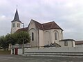
The Parish Church of Saint John the Baptist (1860)![]() is registered as an historical monument.[26]
is registered as an historical monument.[26]
-
 The church front
 -
 The Church Steeple
 -
 The Church Steeple and War Memorial


Amenities edit
Education edit

The town has a kindergarten.
Picture Gallery edit
-
 D134 road bridge over the old railway cutting
 -
 A cross near the railway cutting
 -
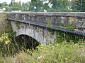
 Old railway bridge near the D134 road
 -
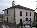 Town Hall
 -
 Towards Sussaute in the distance
 -
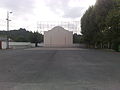 The Fronton
 -
 Entrance to Arbouet
 -
 Old railway cutting
 -
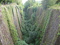 Old railway cutting


See also edit
References edit
- ^ "Répertoire national des élus: les maires" (in French). data.gouv.fr, Plateforme ouverte des données publiques françaises. 13 September 2022.
- ^ "Populations légales 2021". The National Institute of Statistics and Economic Studies. 28 December 2023.
- ^ a b ARBOTI-ZOHOTA, Auñamendi Eusko Entziklopedia (in Spanish)
- ^ Brigitte Jobbé-Duval, Dictionary of placenames - Pyrénées-Atlantiques, 2009, Archives and Culture, ISBN 978-2-35077-151-9 (in French)
- ^ Euskaltzaindia - Academy of the Basque language
- ^ Google Maps
- ^ a b c d Topographic Dictionary of the Department of Basses-Pyrenees, Paul Raymond, Imprimerie nationale, 1863, Digitised from Lyon Public Library 15 June 2011 (in French)
- ^ Euskaltzaindia - Academy of the basque language
- ^ a b New Basque Toponymy, Presses universitaires de Bordeaux, 2006, p. 66-67 ISBN 2 86781 396 4 (in French)
- ^ Cassini Map 1750 – Arbouet-Sussaute
- ^ Notaries of Labastide-Villefranche in the Departmental Archives of Pyrénées-Atlantiques (in French)
- ^ Derecho de naturaleza que la merindad de San-Juan-del-pie-del-puerto, una de las seys de Navarra, tiene en Castilla, 1622 (in Spanish)
- ^ Notaries of Navarrenx in the Departmental Archives of Pyrénées-Atlantiques (in French)
- ^ Titles published by don José Yanguas y Miranda (in Spanish)
- ^ Titles of Mixe in the Departmental Archives of Pyrénées-Atlantiques (in French)
- ^ List of Mayors of France
- ^ Inter-communality of Pyrénées-Atlantiques Archived 2014-02-22 at the Wayback Machine, Cellule informatique préfecture 64, consulted on 19 December 2011 (in French)
- ^ Jean-Baptiste Orpustan, Collective work, Amikuze - the Mixe Country, Éditions Izpegi, 1992, ISBN 2 909262 05 7, page 77 (in French)
- ^ Census cited by Manex Goyhenetche in his General History of Basque Country - Vol. 3, Elkarlanean, 2001, ISBN 2 9131 5634 7, page 26. The same work by Manex Goyhenetche indicated (page 284) that there were an average of 5.5 inhabitants per fire. (in French)
- ^ Transcribed and published by Ricardo Cierbide, Censos de población de la Baja Navarra, Max Niemeyer Verlag, Tübingen, 1993 (in Spanish)
- ^ Departmental Archives of Pyrénées-Atlantiques, E 575, transcribed by Louis Baratchart in The Friends of old Navarre, January 1995, pages 44-54 (in French)
- ^ Bibliothèque nationale, 6956, Moreau register 979, cited by Manex Goyhenetche in General History of Basque Country - Vol. 3, Elkarlanean, 2001, ISBN 2 9131 5634 7, page 299. (in French)
- ^ Des villages de Cassini aux communes d'aujourd'hui: Commune data sheet Arbouet-Sussaute, EHESS (in French).
- ^ Des villages de Cassini aux communes d'aujourd'hui: Commune data sheet Sussaute, EHESS (in French).
- ^ Population en historique depuis 1968, INSEE
- ^ Ministry of Culture, Mérimée IA64000684 Parish Church of Saint John the Baptist (in French)
External links edit
- Arboüet and Sußaute on the 1750 Cassini Map