


Summary
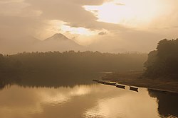
Areekode is a town on the banks of the Chaliyar River in Areekode Grama Panchayat in Malappuram district, India. It was part of the Malabar district in British India.
Areekode
Areacode | |
|---|---|
Town | |
 | |
| Coordinates: 11°14′16″N 76°03′00″E / 11.237716°N 76.050088°E | |
| Country | |
| State | Kerala |
| District | Malappuram |
| Government | |
| • Type | Block Panchayath |
| • Body | UDF |
| Languages | |
| • Official | Malayalam, English |
| Time zone | UTC+5:30 (IST) |
| PIN | 673639 |
| Telephone code | 0483 |
| Vehicle registration | KL-84 |
| Website | http://www.areekode.com/ |
Areekode has an area of 7.25 square miles, and is one of the highly literate areas in the state of Kerala. Situated in the Northern part of Malappuram district, it is encircled by hills and hillocks capped in green. The Areekode region includes Urangatiri, Kizhuparamba, Kavanoor and Areekode panchayats
It is 17 km from Manjeri, 27 km from Malappuram, and 35 km from Calicut town.
Etymology edit

It is believed that the name 'Areekode' was derived from 'Aruvikkode', which in Malayalam means 'riverside'. The town is easily accessible by public road transportation.
Another narrative is that 'Areekode' was derived from 'Arikoda', meaning 'where we get rice', referring to the local market(ചന്ത in Malayalam) which was active once in a week.
History edit
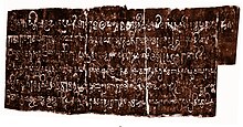
The Kurumathur inscription found near Areekode dates back to 871 CE.[1]
Transportation edit

Areekode connects to other parts of India through Calicut town on the west, Nilambur town on the east, and Manjeri town on the south. It is only 35 km away from Calicut Town. National Highway 66 passes through Calicut and the northern stretch connects to Goa and Mumbai. The southern stretch connects to Cochin and Trivandrum. State Highway 28 starts from Nilambur and connects to Ooty, Mysore, and Bangalore through Highways 12, 29 and 181.
The nearest airport is at Karipur CCJ. Karipur Airport (CCJ - Calicut airport) is 30 minutes away from Areekode.
The nearest major railway station is at Calicut CLT and Nilambur Road NIL.
Frequent Bus Services from Areekode
- Mavoor- Kozhikode
- Mukkam- Kozhikode
- Edavannappara- Kozhikode
- Mukkam- Thiruvambady- Anakkampoyil
- Mukkam-Thamarassery- Kalpetta
- Kizhissery- Kondotty
- Manjeri- Malappuram
- Manjeri- Perinthalmanna
- Othayi- Edvanna
- Edvanna- Nilambur
- Edavanna- Wandur- Kalikavu
- Manjeri- Melattur- Mannarkkad
- Thottumukkam- Thiruvambady
- Vettilappara- Odakkayam
- Kuniyil- Kizhuparamba
- Kariparamba- ITI.
- Thottumukkam- Edakkattuparambu
Important landmarks edit
- 250KV Power Grid
- Chekkunnu Mala.
- Govt. HSS Areacode, Ugrapuram
- Kadungalloor Bridge
- Kurumathur Sree Vishnu Temple
- Malabar Special Police Camp
- Odakkayam Waterfalls
- Pavanna Hanging Bridge
- OTTATHANNIKKAL SREE BHAGAVATHI TEMPLE AND MASJID
- Sree Saligrama Temple, Puthalam
- Thazhathangadi Juma Masjid
- Therattammel ground
- Maithra bridge
- KPM
Educational institutions edit
- Govt. HSS Areacode
- Govt. ITI Areacode
- Sullamussalam Arabic college
- Sullamussalam Oriental HSS Areacode
- Sullamussalam Private ITI
- Sullamussalam Science college
- Sullamussalam Training College
- Kunjathumma Memorial B.Ed College
Hospitals edit
- Government Taluk Hospital
- Aster Mother Areekode
- Alnas Hospital
- Melepurakkal Hospital
Banking Services edit
- SBI Areekode
- SIB Areekode
- CSB Areekode
- KGB Areekode
- Canara Bank
- Federal Bank
- Areacode Co-operative Bank
- Kerala Bank
- Manjeri Co-operative Urban Bank
- HDFC BANK
Travel Agency edit
Suburbs of Areekode edit
- On Mukkam Road
- Pathanapuram, Kuttooli, Valillapuzha.
- On Manjeri Road
- Kavanoor,Kilikkallungal, Elayoor
- On Othayi Road
- Pathanapuram,Therattammal
- Moorkkanad, Thachanna
- Choolattippara,kurikkalampad
- Kallarattikkal, Thachamparamba
- Maithra , Kuthuparamba
- On Edavanna Route
- South Puthalam, Vaakaloor, Vadasseri, Pottiyil, Pannippara, Palepetta
- On Kondotty Route
- Muthuvalloor, Kadungalloor, Kizhisseri, Chemrakkattoor, Pookkattuchola, Kozhakottur, Puthalam
- On Vazhakkad Route
- Ugrapuram, Poonkudi and Vavoor
- Edasserikkadavu and Kizhuparamba
- Vettupara, Edavannappara
- On Thottumukkam Road
- East Vadakkumuri, Vadakkumuri, Kinaradappan, Vettilappara, Odakkayam
- On VETTILAPPARA ROUTE
- Thirattammal, East vadakkumuri, Vadakkumuri, Iriyattuparamb, Ottathannikkal, Kinaradappan
See also edit
- Eranad (State Assembly constituency)
- Eranad
- Omanoor
- Randu Thara Achanmar
References edit
- ^ Veluthat, Kesavan (1 June 2018). "History and historiography in constituting a region: The case of Kerala". Studies in People's History. 5 (1): 13–31. [1]
- ^ "Flight Tickets, Book Flight Tickets Online". Akbar Travels. Retrieved 12 April 2022.
- ^ "Best Travel Agency In Dubai". The Travel Makers. Retrieved 8 January 2024.
- ^ "Best travel portal in India. Lowest fare for Flights, Hotels and Bus". Alhind. Retrieved 12 April 2022.
- ^ "Eranad Online". Eranad.com. Retrieved 12 April 2022.
- ^ "Eranad Admin". Eranad.in. Retrieved 12 April 2022.
- ^ "Popular Now - Leading Travel Company in India and Maldives". Nailatravels.com. Retrieved 12 April 2022.
External links edit
![]() Media related to Areekode at Wikimedia Commons
Media related to Areekode at Wikimedia Commons
- Official website
- www.facebook.com/areekode 1reekode on Facebook