


Summary
Argao, officially the Municipality of Argao (Cebuano: Lungsod sa Argao; Tagalog: Bayan ng Argao), is a 1st class municipality in the province of Cebu, Philippines. According to the 2020 census, it has a population of 78,187 people.[3]
Argao | |
|---|---|
| Municipality of Argao | |
 Old cannons of Argao | |
 Flag | |
 Map of Cebu with Argao highlighted | |
OpenStreetMap .mw-parser-output .locmap .od{position:absolute}.mw-parser-output .locmap .id{position:absolute;line-height:0}.mw-parser-output .locmap .l0{font-size:0;position:absolute}.mw-parser-output .locmap .pv{line-height:110%;position:absolute;text-align:center}.mw-parser-output .locmap .pl{line-height:110%;position:absolute;top:-0.75em;text-align:right}.mw-parser-output .locmap .pr{line-height:110%;position:absolute;top:-0.75em;text-align:left}.mw-parser-output .locmap .pv>div{display:inline;padding:1px}.mw-parser-output .locmap .pl>div{display:inline;padding:1px;float:right}.mw-parser-output .locmap .pr>div{display:inline;padding:1px;float:left}html.skin-theme-clientpref-night .mw-parser-output .od,html.skin-theme-clientpref-night .mw-parser-output .od .pv>div,html.skin-theme-clientpref-night .mw-parser-output .od .pl>div,html.skin-theme-clientpref-night .mw-parser-output .od .pr>div{background:#000;color:#fff}html.skin-theme-clientpref-night .mw-parser-output .locmap{filter:grayscale(0.6)}@media(prefers-color-scheme:dark){html.skin-theme-clientpref-os .mw-parser-output .locmap{filter:grayscale(0.6)}html.skin-theme-clientpref-os .mw-parser-output .od,html.skin-theme-clientpref-os .mw-parser-output .od .pv>div,html.skin-theme-clientpref-os .mw-parser-output .od .pl>div,html.skin-theme-clientpref-os .mw-parser-output .od .pr>div{background:#000;color:#fff}}  Argao Location within the Philippines | |
| Coordinates: 9°53′N 123°36′E / 9.88°N 123.6°E | |
| Country | Philippines |
| Region | Central Visayas |
| Province | Cebu |
| District | 2nd district |
| Founded | 1608 [1] |
| Barangays | 45 (see Barangays) |
| Government | |
| • Type | Sangguniang Bayan |
| • Mayor | Allan M. Sesaldo (1Cebu) |
| • Vice Mayor | Orvi G. Ortega (IND) |
| • Representative | Edsel A. Galeos |
| • Municipal Council | Members |
| • Electorate | 55,846 voters (2022) |
| Area | |
| • Total | 191.50 km2 (73.94 sq mi) |
| Elevation | 43 m (141 ft) |
| Highest elevation | 442 m (1,450 ft) |
| Lowest elevation | 0 m (0 ft) |
| Population (2020 census)[3] | |
| • Total | 78,187 |
| • Density | 410/km2 (1,100/sq mi) |
| • Households | 19,017 |
| Economy | |
| • Income class | 1st municipal income class |
| • Poverty incidence | 15.90 |
| • Revenue | ₱ |
| • Assets | ₱ |
| • Expenditure | ₱ |
| • Liabilities | ₱ |
| Service provider | |
| • Electricity | Cebu 1 Electric Cooperative (CEBECO 1) |
| Time zone | UTC+8 (PST) |
| ZIP code | 6021 |
| PSGC | 072205000 |
| IDD : area code | +63 (0)32 |
| Native languages | Cebuano Tagalog |
| Patron saint | Michael |
Geography edit
The municipality of Argao is located in the southeast of the province of Cebu, 67 kilometres (42 mi) from Cebu City.
Argao is bordered to the north by the municipality of Sibonga, to the west are the municipalities of Ronda, Alcantara and Moalboal, to the east is the Cebu Strait, and to the south is the municipality of Dalaguete.
Barangays edit
Argao is politically subdivided into 45 barangays. Each barangay consists of puroks and some have sitios.
| PSGC | Barangay | Population | ±% p.a. | |||
|---|---|---|---|---|---|---|
| 2020[3] | 2010[5] | |||||
| 072205001 | Alambijud | 2.1% | 1,655 | 1,514 | 0.89% | |
| 072205002 | Anajao | 1.2% | 911 | 907 | 0.04% | |
| 072205003 | Apo | 0.8% | 654 | 664 | −0.15% | |
| 072205004 | Balaas | 1.1% | 892 | 985 | −0.99% | |
| 072205005 | Balisong | 2.9% | 2,275 | 1,944 | 1.58% | |
| 072205006 | Binlod | 5.2% | 4,067 | 3,343 | 1.98% | |
| 072205007 | Bogo | 5.1% | 3,967 | 3,505 | 1.25% | |
| 072205009 | Bug‑ot | 1.1% | 889 | 837 | 0.60% | |
| 072205010 | Bulasa | 5.0% | 3,943 | 3,523 | 1.13% | |
| 072205008 | Butong | 1.3% | 1,011 | 924 | 0.90% | |
| 072205012 | Calagasan | 1.3% | 1,029 | 875 | 1.63% | |
| 072205013 | Canbantug | 1.2% | 932 | 843 | 1.01% | |
| 072205014 | Canbanua | 3.5% | 2,731 | 2,179 | 2.28% | |
| 072205015 | Cansuje | 3.3% | 2,562 | 2,206 | 1.51% | |
| 072205016 | Capio‑an | 1.5% | 1,146 | 1,192 | −0.39% | |
| 072205017 | Casay | 1.3% | 1,040 | 788 | 2.81% | |
| 072205018 | Catang | 0.8% | 645 | 651 | −0.09% | |
| 072205019 | Colawin | 1.5% | 1,198 | 943 | 2.42% | |
| 072205020 | Conalum | 0.8% | 611 | 615 | −0.07% | |
| 072205021 | Guiwanon | 2.4% | 1,839 | 1,726 | 0.64% | |
| 072205022 | Gutlang | 1.0% | 811 | 770 | 0.52% | |
| 072205023 | Jampang | 3.5% | 2,741 | 2,217 | 2.14% | |
| 072205024 | Jomgao | 1.3% | 998 | 1,102 | −0.99% | |
| 072205025 | Lamacan | 3.4% | 2,662 | 2,256 | 1.67% | |
| 072205026 | Langtad | 4.4% | 3,417 | 2,887 | 1.70% | |
| 072205027 | Langub | 1.0% | 768 | 804 | −0.46% | |
| 072205028 | Lapay | 0.8% | 605 | 677 | −1.12% | |
| 072205029 | Lengigon | 1.6% | 1,245 | 989 | 2.33% | |
| 072205030 | Linut‑od | 1.4% | 1,071 | 1,024 | 0.45% | |
| 072205031 | Mabasa | 1.9% | 1,487 | 1,281 | 1.50% | |
| 072205032 | Mandilikit | 0.9% | 722 | 645 | 1.13% | |
| 072205033 | Mompeller | 1.2% | 944 | 753 | 2.29% | |
| 072205034 | Panadtaran | 0.8% | 617 | 524 | 1.65% | |
| 072205035 | Poblacion | 7.7% | 6,009 | 5,570 | 0.76% | |
| 072205036 | Sua | 1.0% | 797 | 755 | 0.54% | |
| 072205037 | Sumaguan | 1.3% | 1,026 | 883 | 1.51% | |
| 072205038 | Tabayag | 1.3% | 983 | 999 | −0.16% | |
| 072205039 | Talaga | 5.0% | 3,937 | 3,485 | 1.23% | |
| 072205040 | Talaytay | 2.4% | 1,891 | 1,438 | 2.78% | |
| 072205041 | Talo‑ot | 5.4% | 4,233 | 3,683 | 1.40% | |
| 072205042 | Tiguib | 1.4% | 1,104 | 1,202 | −0.85% | |
| 072205043 | Tulang | 1.0% | 756 | 869 | −1.38% | |
| 072205044 | Tulic | 3.8% | 2,992 | 2,494 | 1.84% | |
| 072205045 | Ubaub | 1.5% | 1,141 | 968 | 1.66% | |
| 072205046 | Usmad | 1.6% | 1,233 | 1,064 | 1.48% | |
| Total | 78,187 | 69,503 | 1.18% | |||
Climate edit
| Climate data for Argao, Cebu | |||||||||||||
|---|---|---|---|---|---|---|---|---|---|---|---|---|---|
| Month | Jan | Feb | Mar | Apr | May | Jun | Jul | Aug | Sep | Oct | Nov | Dec | Year |
| Mean daily maximum °C (°F) | 29 (84) |
30 (86) |
31 (88) |
32 (90) |
31 (88) |
30 (86) |
30 (86) |
30 (86) |
30 (86) |
29 (84) |
29 (84) |
29 (84) |
30 (86) |
| Mean daily minimum °C (°F) | 23 (73) |
22 (72) |
23 (73) |
24 (75) |
25 (77) |
25 (77) |
24 (75) |
24 (75) |
24 (75) |
24 (75) |
24 (75) |
23 (73) |
24 (75) |
| Average precipitation mm (inches) | 42 (1.7) |
34 (1.3) |
40 (1.6) |
61 (2.4) |
124 (4.9) |
188 (7.4) |
190 (7.5) |
191 (7.5) |
189 (7.4) |
186 (7.3) |
124 (4.9) |
73 (2.9) |
1,442 (56.8) |
| Average rainy days | 10.0 | 8.5 | 9.5 | 12.8 | 22.3 | 26.8 | 28.4 | 27.9 | 27.3 | 27.6 | 20.5 | 13.1 | 234.7 |
| Source: Meteoblue (Use with caution: this is modeled/calculated data, not measured locally.)[6] | |||||||||||||
Demographics edit
| Year | Pop. | ±% p.a. |
|---|---|---|
| 1903 | 35,448 | — |
| 1918 | 39,121 | +0.66% |
| 1939 | 37,331 | −0.22% |
| 1948 | 33,596 | −1.16% |
| 1960 | 32,684 | −0.23% |
| 1970 | 38,039 | +1.53% |
| 1975 | 39,778 | +0.90% |
| 1980 | 44,060 | +2.07% |
| 1990 | 52,157 | +1.70% |
| 1995 | 54,447 | +0.81% |
| 2000 | 61,010 | +2.47% |
| 2007 | 62,226 | +0.27% |
| 2010 | 69,503 | +4.11% |
| 2015 | 72,366 | +0.77% |
| 2020 | 78,187 | +1.53% |
| Source: Philippine Statistics Authority[7][5][8] | ||
Economy edit
Tourism edit
The economy of the town of Argao heavily revolves around farming, baking, and tourism. Argao is renowned in Cebu as the "Torta Capital of the Province" because of its local delicacy, the Torta, a Cebuano tart that is inspired from the Spanish tart, but differs in its recipe by using tubâ or palm wine as the rising agent instead of the usual yeast. There are three Cebuano baking towns, the others are Liloan and Santander.
The La Torta Festival, which replaced the Pitlagong Festival in 2011, is the municipality's local food festival in honor of St Michael the Archangel, the patron saint of Argao. La Torta Festival happens every 28–29 September to celebrate Argao's Tart Economy and the torta as an Argaoanon delicacy, as well as cultural heritage from the Spanish period, which includes the tradition of making the torta.
Argao is also a producer of Cebuano tsokolate (chocolate). Much of the cocoa production originates from Argao. The raw cacao, once harvested, is molded, while melted, into disk-shaped tablets called tablea. These are often used in sikwate, a Cebuano version of hot chocolate. The production of chocolate in Argao is said to have been pre-colonial. Maria Cacao, a goddess of the Lantoy Mountain, is said to have been the giver of the cacao tree to the natives of Argao, according to legend. It is said that she and her husband Mangao reside in a cave in that area, surrounded by cacao trees.
Argao is, additionally, a producer of vinegar in the province. When the tubâ ferments or when it is aged too long, it becomes sour. It eventually turns into vinegar which is used as sauce or as component for a sauce in main courses. The palm vinegar is referred to as sukang tubâ. It is often accompanied with spices such as garlic and chili peppers and usually comes by the bottle.
-
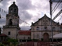 St Michael Parish Church
 -
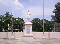 Rizal statue at Municipal plaza
 -
 Argao Public Market


Education edit
The public schools in the town of Argao are administered by two school districts under the Schools Division of Cebu Province.
Elementary schools:
- Alambijud Elementary School — Alambijud
- Anajao Elementary School — Anajao
- Apo Elementary School — Apo
- Argao I Central Elementary School — N. Bacalso Avenue, Poblacion
- Bala-as Elementary School — Bala-as
- Balisong-Casay Elementary School — Balisong
- Banahao Elementary School — Sitio Banahao, Talaga
- Binlod Elementary School — Binlod
- Bogo Elementary School — Bogo
- Bug-ot Elementary School — Bug-ot
- Bulasa Elementary School — Bulasa
- Butong Elementary School — Butong
- Calagasan Elementary School — Calagasan
- Canbantug Elementary School — Canbantug
- Canbanua Elementary School — Dr. T.S. Kintanar Street, Canbanua
- Candolonon Primary School — Sitio Candolonon, Balisong
- Cansuje Elementary School — Cansuje
- Catang Primary School — Catang
- Colawin Elementary School — Colawin
- Conalum Elementary School — Conalum
- Dalas-ag Primary School — Sitio Dalas-ag, Balisong
- Guiwanon Elementary School — Guiwanon
- Gutlang Elementary School — Gutlang
- Jampang Elementary School — Jampang
- Jomgao Elementary School — Jomgao
- Langtad Elementary School — Langtad
- Langub Elementary School — Langub
- Lapay Elementary School — Lapay
- Lengigon Elementary School — Lengigon
- Linut-od Elementary School — Linut-od
- Mabasa Elementary School — Mabasa
- Malacorong Primary School — Sitio Malacorong, Usmad
- Malalag Elementary School — Sitio Malalag, Ubaub
- Mandilikit Elementary School — Mandilikit
- Mompeller Elementary School — Mompeller
- Nug-as Elementary School — Sitio Nug-as, Cansuje
- Rrcy Elementary School — Sitio Candabong, Binlod
- Sua Elementary School — Sua
- Sumaguan Elementary School — Sumaguan
- Tabayag Elementary School — Tabayag
- Talaga Elementary School — Talaga
- Talaytay Elementary School — Talaytay
- Tiguib Elementary School — Tiguib
- Tulang Elementary School — Tulang
- Tulic Elementary School — Isidro Kintanar Street, Tulic
- Usmad Elementary School — Usmad
High schools:
- Argao National High School — San Miguel Street, Canbanua
- Bulasa National High School — Bulasa
- Calagasan National High School — Calagasan
- Cansuje National High School — Cansuje
- Colawin National High School — Colawin
- Mandilikit National High School — Mandilikit
- Talaga National High School — Talaga
- Usmad National High School — Usmad
Integrated schools:
- Taloot Integrated School — Taloot
Notable personalities edit
- Cerge Remonde - former Press Secretary
- Francisco Remotigue - former Governor of Cebu
- Hilario Davide Jr. - former Chief Justice of the Supreme Court
See also edit
References edit
- ^ Encyclopædia Britannica (1911). "Argao". Encyclopædia Britannica. Vol. 2 (11th ed.). p. 457.
- ^ "2015 Census of Population, Report No. 3 – Population, Land Area, and Population Density" (PDF). Philippine Statistics Authority. Quezon City, Philippines. Aug 2016. ISSN 0117-1453. Archived (PDF) from the original on 25 May 2021. Retrieved 16 Jul 2021.
- ^ a b c Census of Population (2020). "Region VII (Central Visayas)". Total Population by Province, City, Municipality and Barangay. Philippine Statistics Authority. Retrieved 8 Jul 2021.
- ^ "PSA Releases the 2018 Municipal and City Level Poverty Estimates". Philippine Statistics Authority. 15 Dec 2021. Retrieved 22 Jan 2022.
- ^ a b Census of Population and Housing (2010). "Region VII (Central Visayas)" (PDF). Total Population by Province, City, Municipality and Barangay. National Statistics Office. Retrieved 29 Jun 2016.
- ^ "Argao: Average Temperatures and Rainfall". Meteoblue. Retrieved 9 May 2020.
- ^ Census of Population (2015). "Region VII (Central Visayas)". Total Population by Province, City, Municipality and Barangay. Philippine Statistics Authority. Retrieved 20 Jun 2016.
- ^ Censuses of Population (1903–2007). "Region VII (Central Visayas)". Table 1. Population Enumerated in Various Censuses by Province/Highly Urbanized City: 1903 to 2007. National Statistics Office.
{{cite encyclopedia}}: CS1 maint: numeric names: authors list (link) - ^ "Poverty incidence (PI):". Philippine Statistics Authority. Retrieved 28 Dec 2020.
- ^ "Estimation of Local Poverty in the Philippines" (PDF). Philippine Statistics Authority. 29 Nov 2005.
- ^ "2003 City and Municipal Level Poverty Estimates" (PDF). Philippine Statistics Authority. 23 Mar 2009.
- ^ "City and Municipal Level Poverty Estimates; 2006 and 2009" (PDF). Philippine Statistics Authority. 3 Aug 2012.
- ^ "2012 Municipal and City Level Poverty Estimates" (PDF). Philippine Statistics Authority. 31 May 2016.
- ^ "Municipal and City Level Small Area Poverty Estimates; 2009, 2012 and 2015". Philippine Statistics Authority. 10 Jul 2019.
- ^ "PSA Releases the 2018 Municipal and City Level Poverty Estimates". Philippine Statistics Authority. 15 Dec 2021. Retrieved 22 Jan 2022.
External links edit
 Media related to Argao at Wikimedia Commons