


Summary
Ariamsvlei is a settlement of about 500 people in the ǁKaras Region of southern Namibia and a small border post between Namibia and South Africa, located 110 kilometres (68 mi) east of Karasburg on the national B3 road. It lies at 804 metres (2641 ft) above sea level.
Ariamsvlei | |
|---|---|
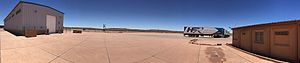 Borderpost at Ariamsvlei | |
 Ariamsvlei Location in Namibia | |
| Coordinates: 28°7′S 19°49′E / 28.117°S 19.817°E | |
| Country | |
| Region | ǁKaras Region |
| Constituency | Karasburg Constituency |
| Population (2016)[1] | |
| • Total | 500 to 600 |
| Time zone | UTC+2 (South African Standard Time) |
The border post with South Africa lies 1.2 kilometres (1,300 yd) to the east of the settlement; however, the actual border (at the 20th meridian east) lies 15.3 kilometres (9.5 mi) further east along the B3, near the South African settlement of Nakop. South Africa's border post (also named Nakop) is located a further 1.3 kilometres (1,400 yd) away.
Ariamsvlei is an important rest stop for long-distance trucks, and a railway stop on the line between Windhoek and Upington. It belongs to the Karasburg electoral constituency.[2] The settlement has a petrol station, a shop, and a restaurant.[1]
References edit
- Ariamsvlei, Namibia Page. Falling Rain Genomics. Retrieved on 2008-04-21.
- Hardy, Paul; Matthew D. Firestone (2007). Botswana & Namibia. Lonely Planet. p. 383. ISBN 1-74104-760-9.