


Summary
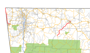
Highway 43 (AR 43, Ark. 43, and Hwy. 43) is a designation for three north–south state highways in Arkansas. One segment of 27.1 miles (43.6 km) runs from Highway 264 in Siloam Springs north into Delaware County, Oklahoma[3] along Oklahoma State Highway 20 (SH-20) to terminate at Missouri Route 43 (Route 43) at the Missouri/Oklahoma/Arkansas tri-point near Southwest City, Missouri.[4] A second segment of 20.0 miles (32.2 km) runs northeast from Highway 21 at Boxley to Highway 7 in Harrison.[5][6] The third segment runs 1.8 miles (2.9 km) north in Harrison from US Route 65 (US 65) to Highway 7 .[6]
Highway 43 | ||||
|---|---|---|---|---|
 | ||||
| Route information | ||||
| Maintained by ArDOT | ||||
| Existed | April 1, 1926[1]–present | |||
| Section 1 | ||||
| Length | 27.1 mi[2] (43.6 km) | |||
| South end | ||||
| North end | Concurrent with OK-20 | |||
| Section 2 | ||||
| Length | 29.525 mi[2] (47.516 km) | |||
| South end | ||||
| North end | ||||
| Section 3 | ||||
| Length | 1.788 mi[2] (2.878 km) | |||
| South end | ||||
| North end | ||||
| Location | ||||
| Country | United States | |||
| State | Arkansas | |||
| Counties | Benton, Boone, Newton, Delaware (OK) | |||
| Highway system | ||||
| ||||

Route description edit
Siloam Springs to Missouri edit


The route begins at AR 264 in Siloam Springs and runs west before turning north and running close to the Oklahoma state line. AR 43 runs through Cherokee City before meeting AR 102 and later AR 72 in Maysville.
After Maysville, AR 43 runs along the Oklahoma state line concurrent with Oklahoma State Highway 20. This continues for approximately 5.4 miles (8.7 km) until both routes terminate at Missouri Route 43. This section is jointly maintained by the Arkansas Department of Transportation (ArDOT) and the Oklahoma Department of Transportation (ODOT).
For the northernmost few miles of the overlapping stretch of road AR 43/SH 20 turns toward the west, no longer straddling the state line. For those few miles, Highway 43 is located wholly within the state of Oklahoma but is not apparent to the traveler.[4] The northernmost few feet of AR 43/OK 20 are completely in Arkansas, as the Arkansas/Missouri/Oklahoma tripoint is on the west side of the highway.
Boxley to Harrison edit
AR 43 begins at Highway 21 at Boxley, and runs north near the Buffalo National River. The route enters Boone County and serves as the western terminus of AR 206, and the southern terminus of AR 397. AR 43 terminates at AR 7 in south Harrison. The route runs for 15.9 miles (25.6 km) in Newton County and 14.1 miles (22.7 km) in Boone County.
Harrison edit
The route begins at U.S. Route 65 on the north end of Harrison and runs east to AR 7 north of Harrison.
Major intersections edit
| State | County | Location | mi | km | Destinations | Notes | |
|---|---|---|---|---|---|---|---|
| Arkansas | Benton | Siloam Springs | 0.000 | 0.000 | Southern terminus | ||
| | 8.0 | 12.9 | |||||
| | 16.3 | 26.2 | AR 102 western terminus | ||||
| Maysville | 18.7 | 30.1 | AR 72 western terminus | ||||
| Oklahoma–Arkansas line | Delaware–Benton county line | | Southern end of SH-20 overlap | ||||
| Oklahoma–Missouri– Arkansas state tripoint | Delaware–McDonald– Benton county tripoint | OKARMO Corner | Continuation into Missouri; northern end of SH-20 overlap | ||||
| Gap in route | |||||||
| Arkansas | Newton | Boxley | 0.000 | 0.000 | Southern terminus | ||
| Ponca | |||||||
| | |||||||
| Boone | | ||||||
| | |||||||
| Harrison | 29.525 | 47.516 | Northern terminus | ||||
| Gap in route | |||||||
| 0.000 | 0.000 | Southern terminus | |||||
| 1.788 | 2.878 | Northern terminus | |||||
1.000 mi = 1.609 km; 1.000 km = 0.621 mi
| |||||||
History edit
Highway 43 was created in the 1926 Arkansas state highway numbering. The original route was designated as State Road 43 between Boxley and Missouri. The route was truncated at State Road 14 at Lead Hill in 1929.[7] The segment between Lead Hill and Harrison was re-signed as Highway 7 in October 1953 following highway reconstruction.[8] Minor relocations also took place around Lead Hill following construction of Bull Shoals Lake in 1954.[9]
The Arkansas State Highway Commission created a second segment of Highway 43 in Harrison on August 25, 1965.[10]
The Arkansas State Highway Commission created a third segment of Highway 43 on October 27, 1971 following a request from the Siloam Springs Chamber of Commerce to provide consistent numbering between Siloam Springs and Joplin, Missouri by renumbering Highway 99 to match Missouri Route 43.[11]
The new segment was rerouted within Siloam Springs as part of a reorganization of the city's highways on July 17, 1996. The Highway Commission relocated the Highway 43 southern terminus from US 412 to Highway 59 by turning over Mount Olive Street to city maintenance and rerouted Highway 43 over the former Highway 204 (Cheri Whitlock Drive) in exchange for street and drainage improvements along Mount Olive Street.[12]
Siloam Springs spur edit
Highway 43S | |
|---|---|
| Location | Siloam Springs |
| Length | 1.01 mi (1.63 km) |
| Existed | July 17, 1996[12] |
Arkansas Highway 43 Spur (AR 43S and Hwy. 43S) is a former spur route of 1.01 miles (1.63 km) in Siloam Springs. It was decommissioned when AR 43 was rerouted along AR 204.[12]
See also edit
 United States portal
 U.S. roads portal
References edit
- ^ Arkansas State Highway Department (April 1, 1926). State of Arkansas Showing System of State Highways (TIF) (Map). 1:500,000. Little Rock: Arkansas State Highway Commission. Retrieved November 29, 2020 – via Arkansas GIS Office.
- ^ a b c System Information and Research Division (2016). "Arkansas Road Log Database". Arkansas State Highway and Transportation Department. Archived from the original (MDB) on August 29, 2017. Retrieved November 29, 2020.
- ^ Delaware County, Oklahoma (PDF) (Map). Oklahoma Department of Transportation. June 2004. Retrieved January 30, 2013.
- ^ a b General Highway Map, Benton County, Arkansas (PDF) (Map). 1:62500. Cartography by Planning and Research Division. Arkansas State Highway and Transportation Department. August 20, 2012. Retrieved January 30, 2013.
- ^ General Highway Map, Newton County, Arkansas (PDF) (Map). 1:62500. Cartography by Planning and Research Division. Arkansas State Highway and Transportation Department. September 16, 1996. Archived from the original (PDF) on September 29, 2011. Retrieved January 30, 2013.
- ^ a b General Highway Map, Boone County, Arkansas (PDF) (Map). 1:62500. Cartography by Planning and Research Division. Arkansas State Highway and Transportation Department. December 22, 2011. Retrieved January 30, 2013.
- ^ Arkansas State Highway Commission (September 1, 1929). State of Arkansas Showing Types of Roads (TIF) (Map). Scale not given. Little Rock: Arkansas State Highway Commission. Retrieved November 29, 2020 – via Arkansas GIS Office.
- ^ "Minutes of the Meeting of the Arkansas State Highway Commission" (PDF). Little Rock: Arkansas State Highway Commission. 1953–1969. p. 2293. OCLC 21798861. Archived from the original (PDF) on October 1, 2018. Retrieved November 28, 2020.
- ^ "Minutes" (1953–69), pp. 2100–2101.
- ^ "Minutes" (1953–69), p. 711.
- ^ "Minutes of the Meeting of the Arkansas State Highway Commission" (PDF). Little Rock: Arkansas State Highway Commission. 1970–1979. pp. 1557–1558. OCLC 21798861. Archived from the original (PDF) on November 5, 2011. Retrieved November 28, 2020.
- ^ a b c "Minutes of the Meeting of the Arkansas State Highway Commission" (PDF). Little Rock: Arkansas State Highway Commission. 1990–1999. pp. 798–800. OCLC 21798861. Archived from the original (PDF) on July 21, 2019. Retrieved November 28, 2020.
External links edit
 Media related to Arkansas Highway 43 at Wikimedia Commons
- AR-43 at Roadklahoma