


Summary
Arques (French pronunciation: [aʁk] ⓘ) is a commune in the Pas-de-Calais department in northern France, bordering Saint-Omer.
Arques | |
|---|---|
 The Fontinettes boat lift | |
 Coat of arms | |
Location of Arques .mw-parser-output .locmap .od{position:absolute}.mw-parser-output .locmap .id{position:absolute;line-height:0}.mw-parser-output .locmap .l0{font-size:0;position:absolute}.mw-parser-output .locmap .pv{line-height:110%;position:absolute;text-align:center}.mw-parser-output .locmap .pl{line-height:110%;position:absolute;top:-0.75em;text-align:right}.mw-parser-output .locmap .pr{line-height:110%;position:absolute;top:-0.75em;text-align:left}.mw-parser-output .locmap .pv>div{display:inline;padding:1px}.mw-parser-output .locmap .pl>div{display:inline;padding:1px;float:right}.mw-parser-output .locmap .pr>div{display:inline;padding:1px;float:left}html.skin-theme-clientpref-night .mw-parser-output .od,html.skin-theme-clientpref-night .mw-parser-output .od .pv>div,html.skin-theme-clientpref-night .mw-parser-output .od .pl>div,html.skin-theme-clientpref-night .mw-parser-output .od .pr>div{background:#000;color:#fff}html.skin-theme-clientpref-night .mw-parser-output .locmap{filter:grayscale(0.6)}@media(prefers-color-scheme:dark){html.skin-theme-clientpref-os .mw-parser-output .locmap{filter:grayscale(0.6)}html.skin-theme-clientpref-os .mw-parser-output .od,html.skin-theme-clientpref-os .mw-parser-output .od .pv>div,html.skin-theme-clientpref-os .mw-parser-output .od .pl>div,html.skin-theme-clientpref-os .mw-parser-output .od .pr>div{background:#000;color:#fff}}  Arques  Arques | |
| Coordinates: 50°44′10″N 2°18′12″E / 50.7361°N 2.3033°E | |
| Country | France |
| Region | Hauts-de-France |
| Department | Pas-de-Calais |
| Arrondissement | Saint-Omer |
| Canton | Longuenesse |
| Intercommunality | CA Pays de Saint-Omer |
| Government | |
| • Mayor (2020–2026) | Benoît Roussel[1] |
| Area 1 | 22.41 km2 (8.65 sq mi) |
| Population (2021)[2] | 9,655 |
| • Density | 430/km2 (1,100/sq mi) |
| Time zone | UTC+01:00 (CET) |
| • Summer (DST) | UTC+02:00 (CEST) |
| INSEE/Postal code | 62040 /62510 |
| Elevation | 2–62 m (6.6–203.4 ft) (avg. 10 m or 33 ft) |
| 1 French Land Register data, which excludes lakes, ponds, glaciers > 1 km2 (0.386 sq mi or 247 acres) and river estuaries. | |
Geography edit
Arques is situated in the middle of the Hauts-de-France region, 40 km from Calais and Dunkerque, and 45 km from Boulogne-sur-Mer. It lies on the border of the departments of Pas-de-Calais and Nord.
The town is crossed by the Neufossé Canal, which connects the rivers Aa and Lys. The commune also includes several lakes—Beauséjour, Arc-en-ciel, Malhôve, Batavia—and part of the forest of Rihout-Clairmarais.
History edit
Arques is in the region of French Flanders. As this area has been under Belgian, English, French and Spanish rule, many of the names are French versions of names in other languages.
In the wake of the Battle of the Golden Spurs a battle was fought here in April 1303 between French and Flemish. The Flemish were victorious in the Battle of Arques (1303). Arques is not to be confused with Arques-la-Bataille, where the Battle of Arques (1589) took place. It is also close to Agincourt.
It was one of the first towns in the region which subscribed to Agenda 21.
Possible Roman influence
There is a possibility of Arques being the Roman Port of 'Marcae' mentioned in the Litus Saxonicum as there appears to be research in the UK that the high sea levels were about 4.5 metres higher in late Roman times than that of today.
Arques is between Oudenberg and Boulogne (both Saxon Shore forts) and appears to be land if the sea level is raised 4.5 metres in which case would mean Arques would have been a well protected harbour inland from the town.[3][4][5]
Population edit
|
| ||||||||||||||||||||||||||||||||||||||||||||||||||||||||||||||||||||||||||||||||||||||||||||||||||||||||||||||||||
| Source: EHESS[6] and INSEE (1968-2017)[7] | |||||||||||||||||||||||||||||||||||||||||||||||||||||||||||||||||||||||||||||||||||||||||||||||||||||||||||||||||||
Economy edit
Arques is famous for its crystal manufacture. It has been the headquarters of Arc International, the largest manufacturer of glassware in the world, since its inception in the 19th century.
Places of interest edit
- The Fontinettes Boat Lift and the Arques lock (l'écluse des Fontinettes, not to be confused with l'ecluse de Flandres, a smaller lock, also in Arques)
- Arc International
- The Aa Valley Tourist Railroad (CFTVA: Chemin de Fer Touristique de la vallée de l'Aa) which runs between Arques and Lumbres[8]
- The Audomarais marshes and the Parc naturel régional des caps et marais d'Opale (a park that runs from the Opal Coast landinwards)
- It is near the Forest of Éperlecques, which houses the Blockhaus d'Éperlecques
- The local church, château and town hall
There is a town walk which takes in most of these sites and can be downloaded from the town website.[9][10]
The town is a ville fleurie and is rated with three flowers.[11]
La Goudale have relocated to Arques from Douai, to a state of the art brewery which can be visited.[12]
See also edit
References edit
- ^ "Répertoire national des élus: les maires" (in French). data.gouv.fr, Plateforme ouverte des données publiques françaises. 13 September 2022.
- ^ "Populations légales 2021". The National Institute of Statistics and Economic Studies. 28 December 2023.
- ^ Explanation of sea level rises based on Anglo Saxon village names at 4.5 metres
- ^ University of Durham Roman sea levels in the Wash at 4.5 metres
- ^ Scalgo with Sea level rises of 4.5 metres around Arques
- ^ Des villages de Cassini aux communes d'aujourd'hui: Commune data sheet Arques, EHESS (in French).
- ^ Population en historique depuis 1968, INSEE
- ^ The CFTVA website
- ^ Le Circuit du Pavé - front
- ^ Le Circuit du Pavé - back
- ^ Arques on the Ville et Villages Fleuris website
- ^ Visiting La Goudale Brewery
External links edit
- Town website
Gallery edit
-
 Fontinettes boat lift
 -
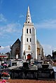 The church
 -
 The Château
 -
 The Town Hall
 -
 The "glass" roundabout


