


Summary
The arrondissement of Nice is an arrondissement of France in the Alpes-Maritimes department in the Provence-Alpes-Côte d'Azur region. It has 101 communes.[2] Its population is 522,637 (2016), and its area is 3,067.4 km2 (1,184.3 sq mi).[3]
Nice | |
|---|---|
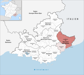 Location within the region Provence-Alpes-Côte d'Azur | |
| Country | France |
| Region | Provence-Alpes-Côte d'Azur |
| Department | Alpes-Maritimes |
| No. of communes | 101 |
| Prefecture | Nice |
| Area | 3,067.4 km2 (1,184.3 sq mi) |
| Population (2021)[1] | 530,694 |
| • Density | 173/km2 (450/sq mi) |
| INSEE code | 062 |
Composition edit
The communes of the arrondissement of Nice, and their INSEE codes, are:[2]
- Ascros (06005)
- Aspremont (06006)
- Auvare (06008)
- Bairols (06009)
- Beaulieu-sur-Mer (06011)
- Beausoleil (06012)
- Belvédère (06013)
- Bendejun (06014)
- Berre-les-Alpes (06015)
- Beuil (06016)
- Blausasc (06019)
- La Bollène-Vésubie (06020)
- Bonson (06021)
- Breil-sur-Roya (06023)
- La Brigue (06162)
- Cantaron (06031)
- Cap-d'Ail (06032)
- Castagniers (06034)
- Castellar (06035)
- Castillon (06036)
- Châteauneuf-d'Entraunes (06040)
- Châteauneuf-Villevieille (06039)
- Clans (06042)
- Coaraze (06043)
- Colomars (06046)
- Contes (06048)
- La Croix-sur-Roudoule (06051)
- Cuébris (06052)
- Daluis (06053)
- Drap (06054)
- Duranus (06055)
- Entraunes (06056)
- L'Escarène (06057)
- Èze (06059)
- Falicon (06060)
- Fontan (06062)
- Gilette (06066)
- Gorbio (06067)
- Guillaumes (06071)
- Ilonse (06072)
- Isola (06073)
- Lantosque (06074)
- Levens (06075)
- Lieuche (06076)
- Lucéram (06077)
- Malaussène (06078)
- Marie (06080)
- Massoins (06082)
- Menton (06083)
- Moulinet (06086)
- Nice (06088)
- Peille (06091)
- Peillon (06092)
- La Penne (06093)
- Péone (06094)
- Pierlas (06096)
- Pierrefeu (06097)
- Puget-Rostang (06098)
- Puget-Théniers (06099)
- Revest-les-Roches (06100)
- Rigaud (06101)
- Rimplas (06102)
- Roquebillière (06103)
- Roquebrune-Cap-Martin (06104)
- Roquestéron (06106)
- La Roquette-sur-Var (06109)
- Roubion (06110)
- Roure (06111)
- Saint-André-de-la-Roche (06114)
- Saint-Antonin (06115)
- Saint-Blaise (06117)
- Saint-Dalmas-le-Selvage (06119)
- Sainte-Agnès (06113)
- Saint-Étienne-de-Tinée (06120)
- Saint-Jean-Cap-Ferrat (06121)
- Saint-Léger (06124)
- Saint-Martin-d'Entraunes (06125)
- Saint-Martin-du-Var (06126)
- Saint-Martin-Vésubie (06127)
- Saint-Sauveur-sur-Tinée (06129)
- Saorge (06132)
- Sauze (06133)
- Sigale (06135)
- Sospel (06136)
- Tende (06163)
- Thiéry (06139)
- Toudon (06141)
- Touët-de-l'Escarène (06142)
- Touët-sur-Var (06143)
- La Tour (06144)
- Tourette-du-Château (06145)
- Tournefort (06146)
- Tourrette-Levens (06147)
- La Trinité (06149)
- La Turbie (06150)
- Utelle (06151)
- Valdeblore (06153)
- Venanson (06156)
- Villars-sur-Var (06158)
- Villefranche-sur-Mer (06159)
- Villeneuve-d'Entraunes (06160)
History edit

The arrondissement of Nice is roughly equivalent to the ancient County of Nice, a historical region belonging first to the Duchy of Savoy and then to the Kingdom of Piedmont-Sardinia. Conquered in 1792 by the armies of the First French Republic, the County of Nice continued to be part of France until 1814; but after that date it reverted to the Kingdom of Piedmont-Sardinia.[4] After the Treaty of Turin was signed in 1860 between the Sardinian king and Napoleon III as a consequence of the Plombières Agreement, the County of Nice was again and definitively ceded to France as a territorial reward for French assistance in the Second Italian War of Independence against Austria, which saw Lombardy united with Piedmont-Sardinia.
In particular, the arrondissement of Nice was created in 1800 during the first French annexation, disbanded in 1814 after the Treaty of Paris, when its territory returned to the Kingdom of Piedmonte-Sardinia, and restored in 1860 after the aforementioned Treaty of Turin.[5] As a result of the reorganisation of the cantons of France which came into effect in 2015, the borders of the cantons are no longer related to the borders of the arrondissements. The cantons of the arrondissement of Nice were, as of January 2015:[6]
- Beausoleil
- Breil-sur-Roya
- Contes
- L'Escarène
- Guillaumes
- Lantosque
- Levens
- Menton-Est
- Menton-Ouest
- Nice 1st Canton
- Nice 2nd Canton
- Nice 3rd Canton
- Nice 4th Canton
- Nice 5th Canton
- Nice 6th Canton
- Nice 7th Canton
- Nice 8th Canton
- Nice 9th Canton
- Nice 10th Canton
- Nice 11th Canton
- Nice 12th Canton
- Nice 13th Canton
- Nice 14th Canton
- Puget-Théniers
- Roquebillière
- Roquestéron
- Saint-Étienne-de-Tinée
- Saint-Martin-Vésubie
- Saint-Sauveur-sur-Tinée
- Sospel
- Tende
- Villars-sur-Var
- Villefranche-sur-Mer
References edit
- ^ "Téléchargement du fichier d'ensemble des populations légales en 2021". The National Institute of Statistics and Economic Studies. 28 December 2023.
- ^ a b "Arrondissement de Nice (062)". INSEE. Retrieved 2019-09-26.
- ^ "Comparateur de territoire, géographie au 01/01/2019". INSEE. Retrieved 2019-09-26.
- ^ One or more of the preceding sentences incorporates text from a publication now in the public domain: Chisholm, Hugh, ed. (1911). "Nice". Encyclopædia Britannica. Vol. 19 (11th ed.). Cambridge University Press. pp. 646–647.
- ^ Historique des Alpes-Maritimes
- ^ Populations légales 2012: 06 Alpes-Maritimes, INSEE
43°42′N 7°16′E / 43.700°N 7.267°E