


Summary
The arrondissement of Rodez is an arrondissement of France in the Aveyron department in the Occitanie region. It has 79 communes.[2] Its population is 111,180 (2016), and its area is 2,869.7 km2 (1,108.0 sq mi).[3]
Rodez | |
|---|---|
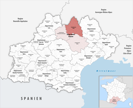 Location within the region Occitanie | |
| Country | France |
| Region | Occitania |
| Department | Aveyron |
| No. of communes | 79 |
| Prefecture | Rodez |
| Area | 2,869.7 km2 (1,108.0 sq mi) |
| Population (2021)[1] | 112,628 |
| • Density | 39/km2 (100/sq mi) |
| INSEE code | 122 |
Composition edit
The communes of the arrondissement of Rodez, and their INSEE codes, are:[2]
- Argences-en-Aubrac (12223)
- Bertholène (12026)
- Bessuéjouls (12027)
- Bozouls (12033)
- Brommat (12036)
- Campagnac (12047)
- Campouriez (12048)
- Campuac (12049)
- Cantoin (12051)
- La Capelle-Bonance (12055)
- Cassuéjouls (12058)
- Castelnau-de-Mandailles (12061)
- Le Cayrol (12064)
- Clairvaux-d'Aveyron (12066)
- Condom-d'Aubrac (12074)
- Conques-en-Rouergue (12076)
- Coubisou (12079)
- Curières (12088)
- Druelle Balsac (12090)
- Entraygues-sur-Truyère (12094)
- Espalion (12096)
- Espeyrac (12097)
- Estaing (12098)
- Le Fel (12093)
- Florentin-la-Capelle (12103)
- Gabriac (12106)
- Gaillac-d'Aveyron (12107)
- Golinhac (12110)
- Huparlac (12116)
- Lacroix-Barrez (12118)
- Laguiole (12119)
- Laissac-Sévérac-l'Église (12120)
- Lassouts (12124)
- La Loubière (12131)
- Luc-la-Primaube (12133)
- Marcillac-Vallon (12138)
- Le Monastère (12146)
- Montézic (12151)
- Montpeyroux (12156)
- Montrozier (12157)
- Mouret (12161)
- Mur-de-Barrez (12164)
- Muret-le-Château (12165)
- Murols (12166)
- Nauviale (12171)
- Le Nayrac (12172)
- Olemps (12174)
- Onet-le-Château (12176)
- Palmas-d'Aveyron (12177)
- Pierrefiche (12182)
- Pomayrols (12184)
- Prades-d'Aubrac (12187)
- Pruines (12193)
- Rodelle (12201)
- Rodez (12202)
- Saint-Amans-des-Cots (12209)
- Saint-Christophe-Vallon (12215)
- Saint-Chély-d'Aubrac (12214)
- Saint-Côme-d'Olt (12216)
- Sainte-Eulalie-d'Olt (12219)
- Sainte-Radegonde (12241)
- Saint-Félix-de-Lunel (12221)
- Saint-Geniez-d'Olt-et-d'Aubrac (12224)
- Saint-Hippolyte (12226)
- Saint-Laurent-d'Olt (12237)
- Saint-Martin-de-Lenne (12239)
- Saint-Saturnin-de-Lenne (12247)
- Saint-Symphorien-de-Thénières (12250)
- Salles-la-Source (12254)
- Sébazac-Concourès (12264)
- Sébrazac (12265)
- Sénergues (12268)
- Sévérac-d'Aveyron (12270)
- Soulages-Bonneval (12273)
- Taussac (12277)
- Thérondels (12280)
- Valady (12288)
- Villecomtal (12298)
- Vimenet (12303)
History edit
The arrondissement of Rodez was created in 1800.[4] At the January 2017 reorganization of the arrondissements of Aveyron, it lost 19 communes to the arrondissement of Millau and 34 communes to the arrondissement of Villefranche-de-Rouergue, and it gained six communes from the arrondissement of Millau.[5]
As a result of the reorganisation of the cantons of France which came into effect in 2015, the borders of the cantons are no longer related to the borders of the arrondissements. The cantons of the arrondissement of Rodez were, as of January 2015:[6]
- Baraqueville-Sauveterre
- Bozouls
- Cassagnes-Bégonhès
- Conques
- Entraygues-sur-Truyère
- Espalion
- Estaing
- Laguiole
- Laissac
- Marcillac-Vallon
- Mur-de-Barrez
- Naucelle
- Pont-de-Salars
- Réquista
- Rignac
- Rodez-Est
- Rodez-Nord
- Rodez-Ouest
- Saint-Amans-des-Cots
- Saint-Chély-d'Aubrac
- Sainte-Geneviève-sur-Argence
- Saint-Geniez-d'Olt
- La Salvetat-Peyralès
References edit
- ^ "Téléchargement du fichier d'ensemble des populations légales en 2021". The National Institute of Statistics and Economic Studies. 28 December 2023.
- ^ a b "Arrondissement de Rodez (122)". INSEE. Retrieved 2019-09-27.
- ^ "Comparateur de territoire, géographie au 01/01/2019". INSEE. Retrieved 2019-09-27.
- ^ Historique de l'Aveyron
- ^ "Arrêté préfectoral, 29 December 2016, p. 27" (PDF). Retrieved 2019-10-08.
- ^ "Populations légales 2012: 12 Aveyron" (PDF). INSEE. December 2014.
44°20′N 2°34′E / 44.33°N 2.57°E