


Summary
Arros-de-Nay (French pronunciation: [aʁɔs də naj]; Occitan: Arròs de Nai) is a commune in the Pyrénées-Atlantiques department in the Nouvelle-Aquitaine region of south-western France.
Arros-de-Nay | |
|---|---|
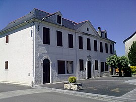 Town hall | |
 Coat of arms | |
Location of Arros-de-Nay .mw-parser-output .locmap .od{position:absolute}.mw-parser-output .locmap .id{position:absolute;line-height:0}.mw-parser-output .locmap .l0{font-size:0;position:absolute}.mw-parser-output .locmap .pv{line-height:110%;position:absolute;text-align:center}.mw-parser-output .locmap .pl{line-height:110%;position:absolute;top:-0.75em;text-align:right}.mw-parser-output .locmap .pr{line-height:110%;position:absolute;top:-0.75em;text-align:left}.mw-parser-output .locmap .pv>div{display:inline;padding:1px}.mw-parser-output .locmap .pl>div{display:inline;padding:1px;float:right}.mw-parser-output .locmap .pr>div{display:inline;padding:1px;float:left}html.skin-theme-clientpref-night .mw-parser-output .od,html.skin-theme-clientpref-night .mw-parser-output .od .pv>div,html.skin-theme-clientpref-night .mw-parser-output .od .pl>div,html.skin-theme-clientpref-night .mw-parser-output .od .pr>div{background:#000;color:#fff}html.skin-theme-clientpref-night .mw-parser-output .locmap{filter:grayscale(0.6)}@media(prefers-color-scheme:dark){html.skin-theme-clientpref-os .mw-parser-output .locmap{filter:grayscale(0.6)}html.skin-theme-clientpref-os .mw-parser-output .od,html.skin-theme-clientpref-os .mw-parser-output .od .pv>div,html.skin-theme-clientpref-os .mw-parser-output .od .pl>div,html.skin-theme-clientpref-os .mw-parser-output .od .pr>div{background:#000;color:#fff}}  Arros-de-Nay  Arros-de-Nay | |
| Coordinates: 43°12′01″N 0°17′09″W / 43.2003°N 0.2858°W | |
| Country | France |
| Region | Nouvelle-Aquitaine |
| Department | Pyrénées-Atlantiques |
| Arrondissement | Pau |
| Canton | Ouzom, Gave et Rives du Neez |
| Intercommunality | CC Pays Nay |
| Government | |
| • Mayor (2020–2026) | Gérard d'Arros[1] |
| Area 1 | 13.47 km2 (5.20 sq mi) |
| Population (2021)[2] | 800 |
| • Density | 59/km2 (150/sq mi) |
| Time zone | UTC+01:00 (CET) |
| • Summer (DST) | UTC+02:00 (CEST) |
| INSEE/Postal code | 64054 /64800 |
| Elevation | 230–421 m (755–1,381 ft) (avg. 236 m or 774 ft) |
| 1 French Land Register data, which excludes lakes, ponds, glaciers > 1 km2 (0.386 sq mi or 247 acres) and river estuaries. | |
Geography edit
Arros-de-Nay is part of the urban area of Pau located in the heart of a valley between wooded hills and the Gave de Pau some 13 km south-east of Pau immediately east of Nay. The commune has been administered by the department of Pyrénées-Atlantiques since 1969 (formerly it had been in the Department of Basses-Pyrénées since 1793). The commune has about 300 houses. The altitude varies from 230 metres to 421 metres, with 243 metres in the village centre. This is one of the largest communal areas of the region with areas of plains and hilly areas with a livable areas in the north and in the hamlets.
Access to the commune is by road D37 from Saint-Abit in the north passing through the village and the northern corner of the commune continuing to Bourdettes in the south. The D936 goes west from the village then south-west to Rébénacq. The D288 road goes south from the village through the length of the commune to join the D287 north of Lys. The D388 branches from the D288 and goes south-west by a different route to join the D288 again south-west of the commune. The D287 goes south-west from Nay passing along the south-eastern border of the commune and continuing south-west to Sévignacq-Meyracq.[3]
The commune is located in the Drainage basin of the Adour with the Luz flowing from the south through the length of the commune collecting many tributaries and continuing north to join the Gave de Pau near Narcastet. The Escourre flows north through the northern corner of the commune and the north-eastern tip of the commune touches the Gave de Pau.
Places and Hamlets edit
- Allemand (hill)
- Bacabara
- Barbé
- Barrère
- Barthe
- Bées[4]
- Bégué
- La Bernadie
- Bois de Bié (forest)[4]
- Blanquet
- Blon
- Bouhabent
- Bourda-Plà
- Bouria
- Bozom[4]
- Brouquet
- Brousset
- Cabarry
- Casamayou
- Casenave
- Castéra
- Cataline
- La Châtaigneraie (two places)
- Grange Clédou
- Couchies
- Coumet
- Daguès-Bié
- Gahuset
- Guillamasse
- Habarna
- Habe
- Haure
- Hourcade
- Jupé
- Labasserres
- Labourie
- Lacrouts
- Ladebat
- Lambrou
- Lanot
- Lasbordes
- Bois de Lauga (forest)
- Lème Carraze
- Lème Monlucou
- Lolou
- Grange Lolou
- Lombré
- Massaly (ruins)
- Michelat
- Grange Miramon
- Moncaut (spring)
- Mondaut
- Grange Monsempès
- Moun du Rey
- Mourtérou
- Nérios
- Ourthe
- L'Oustau
- Paloc
- Petit Paloc
- Pareil
- Pédemelou
- Le Petit Hameau
- Picourlat
- Plà
- Le Point de Vue
- Porteteny
- Rieupeyrous
- Thomas
- Toulet
- Tourne (ruins)
Neighbouring communes and villages edit
Toponymy edit
The commune name in béarnais is Arros de Nai.
Michel Grosclaude, with much reservation, suggested an Aquitaine root of (h)arr ("stone" or "rock") with the suffix -ossum, which gives a meaning "where there are rocks".[5]
The following table details the origins of the commune name and other names in the commune.
| Name | Spelling | Date | Source | Page | Origin | Description |
|---|---|---|---|---|---|---|
| Arros | Arrossium | 1100 | Raymond | 13 |
Titles of Mifaget | Village |
| Arros | 1120 | Grosclaude | ||||
| Arrode | 12th century | Raymond | 13 |
Marca | ||
| Rode | 12th century | Raymond | 13 |
Marca | ||
| Arros | 1286 | Pau | ||||
| Arros | 1750 | Cassini | ||||
| Bées | le Bée | 1675 | Raymond | 26 |
Reformation | Stream rising at Capbis and joining the Gave de Pau after flowing through Asson, and Arros-de-Nay. |
| Le Béès | 1863 | Raymond | 26 |
|||
| Bié | Bier | 1385 | Raymond | 31 |
Census | Farm |
| Bozom | La Monyoge de Bosom | 1536 | Raymond | 36 |
Reformation | Farm |
| Bouzoum | 1863 | Raymond | 36 |
|||
| Château d'Espalungue | Espalungue | 1863 | Raymond | 61 |
Chateau | |
| Laragnous | Laranhoet | 1385 | Raymond | 93 |
Census | Farm |
Sources:
- Raymond: Topographic Dictionary of the Department of Basses-Pyrenees, 1863, on the page numbers indicated in the table. (in French)[4]
- Grosclaude: Toponymic Dictionary of communes, Béarn, 2006 (in French)[5]
- Pau: Cartulary of the Château of Pau[6]
- Cassini: Cassini Map from 1750[7]
Origins:
- Marca: Pierre de Marca, History of Béarn.[8]
- Reformation: Reformation of Béarn[9]
- Census: Census of Béarn[10]
On 27 January 1932 the prefect, citing consecutive administrative mistakes from the plurality of the name Arros in the department (Arros Canton of Nay, Arros Canton of Oloron), decided to associate the name of the chief town of the canton with that of the commune and asked the Municipal Council to endorse his decision. The council of the time complied and the name became Arros-de-Nay.
History edit

The first traces of the village date to the 11th century when it was cited with the name Arrossium ("place where there are rocks"). In the 12th century a noble family (de Rode, d'Arrode, then d'Arros) who owned the Lordships of Rode, Vauzé, the Viguerie of Lembeye took possession of the fief which became Arrode then later Arros.
Paul Raymond noted that, in 1385, Arros had 44 fires and depended on the bailiwick of Pau. Arros, with its hamlets towards Bosdarros ('Bois d'Arros'), was the seventh largest of the twelve large Baronies of Béarn.[4]
Heraldry edit
 |
Each lozenge represents one of the five districts: the village (where the chateau is), Moun de Rey, Bois de Bié, Les Labassères, le Petit Hameau.[11]
Blazon:
|
Administration edit
List of Successive Mayors[12]
| From | To | Name |
|---|---|---|
| 1793 | 1796 | Jean Laban |
| 1796 | 1799 | Jean Lassus |
| 1799 | 1802 | Jean Grilhere |
| 1802 | 1805 | Joseph Miramon |
| 1805 | 1809 | Jean-Baptiste d'Espalungue |
| 1835 | Miramon | |
| 1867 | 1871 | Miramon |
| 1871 | 1882 | Suberbielle |
| 1882 | 1887 | Henri d'Espalungue |
| 1887 | 1888 | Alexis Barrère |
| 1888 | 1896 | Marcel Miramon |
| 1896 | 1900 | Armand d'Espalungue |
| 1900 | 1904 | Jean-Alexis Dufau |
| 1904 | 1912 | Armand d'Espalungue |
| 1912 | 1919 | Jean Dufau |
| 1919 | 1923 | Édouard Meniche |
- Mayors from 1961
| From | To | Name |
|---|---|---|
| 1961 | 1977 | Léon Fiol |
| 1977 | 1983 | Jean Buisson |
| 1983 | 1995 | Jean Berrette |
| 1995 | 2001 | André Broqué |
| 2001 | 2014 | Georges Bordenave |
| 2014 | 2026 | Gérard d'Arros |
Inter-communality edit
The commune is part of seven inter-communal structures:
- the Communauté de communes du Pays de Nay;
- the AEP association of Nay-Ouest;
- the Sanitation association of Pays du Nay;
- the Energy association of Pyrénées-Atlantiques;
- the inter-communal association for the defence against floods of the Gave de Pau;
- the inter-communal association for the defence against floods of the Luz;
- the inter-communal association for the construction of the CES of Nay;
Demography edit
The inhabitants of the commune are known as Arrosiens or Arrosiennes in French.[13]
|
| ||||||||||||||||||||||||||||||||||||||||||||||||||||||||||||||||||||||||||||||||||||||||||||||||||||||||||||||||||
| Source: EHESS[14] and INSEE[15] | |||||||||||||||||||||||||||||||||||||||||||||||||||||||||||||||||||||||||||||||||||||||||||||||||||||||||||||||||||
Economy edit

The commune is part of the Appellation d'origine contrôlée (AOC) zone designation of Ossau-iraty.
Culture and Heritage edit
Civil heritage edit
The Chateau of Arros (17th century)![]() is registered as an historical monument.[16]
is registered as an historical monument.[16]
Religious heritage edit

- The Parish Church of Saint-Jacques-le-Majeur (1835)
 is registered as an historical monument.[17]
Education edit
Arros-de-Nay has a primary school.
See also edit
References edit
- ^ "Répertoire national des élus: les maires". data.gouv.fr, Plateforme ouverte des données publiques françaises (in French). 2 December 2020.
- ^ "Populations légales 2021". The National Institute of Statistics and Economic Studies. 28 December 2023.
- ^ Google Maps
- ^ a b c d e Topographic Dictionary of the Department of Basses-Pyrenees, Paul Raymond, Imprimerie nationale, 1863, Digitised from Lyon Public Library 15 June 2011 (in French)
- ^ a b Michel Grosclaude, Toponymic Dictionary of communes, Béarn, Edicions reclams & Édition Cairn - 2006, 416 pages, ISBN 2-35068-005-3 (in French)
- ^ Manuscripts in two volumes from the 17th century in the Departmental Archives of Pyrénées-Atlantiques (in French)
- ^ Cassini Map 1750 – Arros-de-Nay
- ^ Pierre de Marca, History of Béarn
- ^ Manuscript from the 16th to 18th centuries - Departmental Archives of Pyrénées-Atlantiques (in French)
- ^ Manuscript from the 14th century - Departmental Archives of Pyrénées-Atlantiques (in French)
- ^ Arms of France (in French)
- ^ List of Mayors of France (in French)
- ^ Pyrénées-Atlantiques, habitants.fr
- ^ Des villages de Cassini aux communes d'aujourd'hui: Commune data sheet Arros-de-Nay, EHESS (in French).
- ^ Population en historique depuis 1968, INSEE
- ^ Ministry of Culture, Mérimée PA00084318 Chateau of Arros (in French)
- ^ Ministry of Culture, Mérimée IA64000597 Parish Church of Saint-Jacques-le-Majeur (in French)
External links edit
- Arros on the 1750 Cassini Map