


Summary
Artemps is a commune in the department of Aisne in the Hauts-de-France region of northern France.
Artemps | |
|---|---|
Commune | |
 Rue du canal | |
Location of Artemps .mw-parser-output .locmap .od{position:absolute}.mw-parser-output .locmap .id{position:absolute;line-height:0}.mw-parser-output .locmap .l0{font-size:0;position:absolute}.mw-parser-output .locmap .pv{line-height:110%;position:absolute;text-align:center}.mw-parser-output .locmap .pl{line-height:110%;position:absolute;top:-0.75em;text-align:right}.mw-parser-output .locmap .pr{line-height:110%;position:absolute;top:-0.75em;text-align:left}.mw-parser-output .locmap .pv>div{display:inline;padding:1px}.mw-parser-output .locmap .pl>div{display:inline;padding:1px;float:right}.mw-parser-output .locmap .pr>div{display:inline;padding:1px;float:left}html.skin-theme-clientpref-night .mw-parser-output .od,html.skin-theme-clientpref-night .mw-parser-output .od .pv>div,html.skin-theme-clientpref-night .mw-parser-output .od .pl>div,html.skin-theme-clientpref-night .mw-parser-output .od .pr>div{background:#000;color:#fff}html.skin-theme-clientpref-night .mw-parser-output .locmap{filter:grayscale(0.6)}@media(prefers-color-scheme:dark){html.skin-theme-clientpref-os .mw-parser-output .locmap{filter:grayscale(0.6)}html.skin-theme-clientpref-os .mw-parser-output .od,html.skin-theme-clientpref-os .mw-parser-output .od .pv>div,html.skin-theme-clientpref-os .mw-parser-output .od .pl>div,html.skin-theme-clientpref-os .mw-parser-output .od .pr>div{background:#000;color:#fff}}  Artemps  Artemps | |
| Coordinates: 49°45′57″N 3°11′26″E / 49.7658°N 3.1906°E | |
| Country | France |
| Region | Hauts-de-France |
| Department | Aisne |
| Arrondissement | Saint-Quentin |
| Canton | Ribemont |
| Intercommunality | CA Saint-Quentinois |
| Government | |
| • Mayor (2020–2026) | Jean-Claude Dusanter[1] |
| Area 1 | 6.31 km2 (2.44 sq mi) |
| Population (2021)[2] | 365 |
| • Density | 58/km2 (150/sq mi) |
| Time zone | UTC+01:00 (CET) |
| • Summer (DST) | UTC+02:00 (CEST) |
| INSEE/Postal code | 02025 /02480 |
| Elevation | 62–93 m (203–305 ft) (avg. 77 m or 253 ft) |
| 1 French Land Register data, which excludes lakes, ponds, glaciers > 1 km2 (0.386 sq mi or 247 acres) and river estuaries. | |
Geography edit
Artemps is located 10 km southwest of Saint-Quentin and 7 km northeast of Ham. It can be accessed by the D32 road from Saint-Simon in the south passing through the heart of the commune and the village and continuing to Seraucourt-le-Grand in the north. There are a few country roads in the commune and the old Saint-Simon – Clastres Air Base is in the southeast of the commune. The commune is mostly farmland with a forest belt along the whole northern border.[3]
The Somme river flows along the northern border forming part of the border and the Canal of Saint-Quentin passes through parallel to the river inside the commune.[3]
Neighbouring communes and villages edit
Administration edit
This list is incomplete; you can help by adding missing items. (April 2021) |
List of Successive Mayors of Artemps[4]
| From | To | Name | Party |
|---|---|---|---|
| 2001 | Present | Jean-Claude Dusanter | DVD |
Population edit
| Year | Pop. | ±% p.a. |
|---|---|---|
| 1968 | 289 | — |
| 1975 | 292 | +0.15% |
| 1982 | 297 | +0.24% |
| 1990 | 347 | +1.96% |
| 1999 | 338 | −0.29% |
| 2007 | 356 | +0.65% |
| 2012 | 360 | +0.22% |
| 2017 | 371 | +0.60% |
| Source: INSEE[5] | ||

Sites and Monuments edit

- St. Martin's Church
This church is one of the few in France to have a steeple topped by two cocks. The church has undergone many changes over the years but was not completely destroyed during the two world wars. Most windows have been preserved and on one of them the master glassmaker represented the church.
-
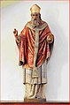 Statue of Saint Pierre in the church
 -
 Stained glass window in the church
 -
 The steeple with its two cocks


See also edit
References edit
- ^ "Répertoire national des élus: les maires". data.gouv.fr, Plateforme ouverte des données publiques françaises (in French). 2 December 2020.
- ^ "Populations légales 2021". The National Institute of Statistics and Economic Studies. 28 December 2023.
- ^ a b c Google Maps
- ^ List of Mayors of France (in French)
- ^ Population en historique depuis 1968, INSEE
External links edit
- Artemps on the old IGN website (in French)
- Bell Towers website (in French)
- Artemps on Géoportail, National Geographic Institute (IGN) website (in French)
- Arthem on the 1750 Cassini Map