


Summary
Asaminami-ku (安佐南区) is one of the eight wards of the city of Hiroshima, located in the south of former Asa District.
Asaminami-ku, Hiroshima
広島市安佐南区 | |
|---|---|
Ward of Hiroshima | |
| 安佐南区• Asaminami-ku | |
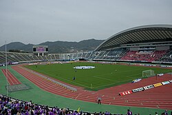 Hiroshima Big Arch | |
 Flag | |
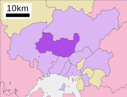 Location of Mihama in Asaminami-ku in Hiroshima City | |
 Asaminami-ku, Hiroshima | |
| Coordinates: 34°27′07″N 132°28′19″E / 34.45194°N 132.47194°E | |
| Country | Japan |
| Region | Chūgoku (Sanyo) |
| Prefecture | Hiroshima |
| City | Hiroshima |
| Area | |
| • Total | 117.24 km2 (45.27 sq mi) |
| Population | |
| • Total | 245,475 |
| • Density | 2,094/km2 (5,420/sq mi) |
| Time zone | UTC+9 (Japan Standard Time) |
| Postal | 731-0193 |
| Asaminami Ward Office's Address | Furuichi 1-33-14, Asaminami-ku, Hiroshima City, Hiroshima Prefecture (広島県広島市安佐南区古市1丁目33番14号) |
| Phone | 81-(0)82-831-4925, 831-4927 |
Asa District consisted of Gion-cho, Yasufuruichi-cho, Sato-cho, Numata-cho. After being merged with Hiroshima in 1973, this ward was named Asaminami-ku. The largest station of Astramline, a new traffic system, is in Asaminami-ku. This system brought population inflow.[citation needed]
As of January 1, 2018, the ward has an estimated population of 245,475, with 101,941 households and a density of 2094 persons per km2. The total area is 117.24 km2.[2][1]
Transportation edit
JR-Kabe line edit
Astram line edit
Expressway edit
- San'yō Expressway
- Hiroshima IC
- Numata PA
- Hiroshima JCT
- Hiroshima Expressway (West Nippon Expressway Company)
- Hiroshimaseifushinto IC
- Hiroshima Expressway
- Numata IC
Industry edit
Hiroshima Mitsubishi Heavy Industries in Gion closed its doors in 2003.
Education edit
Agriculture edit
Former Sato-cho, now a part of the ward, has been a major production area for Hiroshimana since Meiji era. Hiroshimana is a variety of Chinese cabbage and is the main material used for making Hiroshimanazuke (literally "pickled Hiroshimana").[3][4][5]
Landslide edit
In August 2014 many people died in a landslide after very heavy rain.[6]
Footnotes edit
- ^ The density was calculated based on the population estimates and the total area.
References edit
- ^ a b "広島市 - 面積" (in Japanese). Hiroshima City. Archived from the original on April 26, 2017. Retrieved February 5, 2018.
- ^ a b "広島市 - 推計人口" (in Japanese). Hiroshima City. Archived from the original on February 6, 2018. Retrieved February 5, 2018.
- ^ "佐東(さとう)とは - コトバンク". kotobank (in Japanese). Retrieved February 5, 2018.
- ^ "広島菜(ヒロシマナ)とは - コトバンク". kotobank (in Japanese). Retrieved February 5, 2018.
- ^ Mikami Shousou (1998). 広島菜栽培地域川内地区の経済地理学的研究. 広島経済大学研究双書 (in Japanese). Hiroshima University of Economics. pp. 6–9. JPNO 99107788.
- ^ "Japan landslides: deaths confirmed after homes swept away". the Guardian. August 20, 2014.