


Summary
Aschaffenburg (Low Franconian: Aschebersch) is a Landkreis (district) in Bavaria, Germany. It is bounded by (from the west and clockwise) the districts of Darmstadt-Dieburg, Offenbach, Main-Kinzig (all in the state of Hesse), the districts Main-Spessart and Miltenberg, and the town of Aschaffenburg.
Aschaffenburg | |
|---|---|
 Flag  Coat of arms | |
 | |
| Country | Germany |
| State | Bavaria |
| Adm. region | Lower Franconia |
| Capital | Aschaffenburg (extraterritorial) |
| Government | |
| • District admin. | Alexander Legler (CSU) |
| Area | |
| • Total | 699 km2 (270 sq mi) |
| Population (31 December 2022)[1] | |
| • Total | 176,958 |
| • Density | 250/km2 (660/sq mi) |
| Time zone | UTC+01:00 (CET) |
| • Summer (DST) | UTC+02:00 (CEST) |
| Vehicle registration | AB, ALZ |
| Website | www |
History edit
The Aschaffenburg history goes back to as far as the year 957. Initially, being a Roman settlement, it came under the authority of the electors of Mainz in 982 and was chartered in 1173. Remains of Roman settlements were found on the river Main. There was a Roman military camp in what is today the municipality of Stockstadt am Main. After the Roman retreat the region became subject to Alemanni and Franks before eventually being a part of the Electorate of Mainz. While the banks of the Main were populated all these centuries, the hills of the Spessart were virtually unsettled until the 13th century.
The districts of Aschaffenburg and Alzenau were established in 1862, half a century after the region was annexed by the state of Bavaria. These districts were merged in 1972 in order to form the present district.
Geography edit
The district is located in the extreme northwest of Bavaria and bounded by Hesse on two sides. The Main river forms the western border, though southwest of the town of Aschaffenburg there are also parts on the western river banks incorporated in the district. The south and east of the district extends into the Mittelgebirge Spessart.
The town of Aschaffenburg is not included in the district ( kreisfrei ), but is nonetheless its administrative seat.
The geographic centre of the European Union was located in the District of Aschaffenburg from 2013 to 2020.
Economy edit
In 2017 (latest data available) the GDP per inhabitant was €33,109. This places the district 60th out of 96 districts (rural and urban) in Bavaria (overall average: €46,698).[2]
Coat of arms edit
The coat of arms displays:
- an acorn symbolising the Spessart hills and their dense forests
- the wheel of the electorate of Mainz
- the blue rings of the Echter family, which was a noble family possessing substantial holdings of land in the region
Towns and municipalities edit
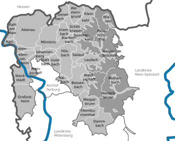
Towns:
Municipalities:
- Bessenbach
- Blankenbach
- Dammbach
- Geiselbach
- Glattbach
- Goldbach
- Großostheim
- Haibach
- Heigenbrücken
- Heimbuchenthal
- Heinrichsthal
- Hösbach
- Johannesberg
- Kahl am Main
- Karlstein am Main
- Kleinkahl
- Kleinostheim
- Krombach
- Laufach
- Mainaschaff
- Mespelbrunn
- Mömbris
- Rothenbuch
- Sailauf
- Schöllkrippen
- Sommerkahl
- Stockstadt am Main
- Waldaschaff
- Weibersbrunn
- Westerngrund
- Wiesen
References edit
- ^ Genesis Online-Datenbank des Bayerischen Landesamtes für Statistik Tabelle 12411-003r Fortschreibung des Bevölkerungsstandes: Gemeinden, Stichtag (Einwohnerzahlen auf Grundlage des Zensus 2011) (Hilfe dazu).
- ^ "VGR der Länder, Kreisergebnisse für Deutschland - Bruttoinlandsprodukt, Bruttowertschöpfung in den kreisfreien Städten und Landkreisen der Bundesrepublik Deutschland 2000 bis 2017 (German)". Statistische Ämter der Länder und des Bundes. Archived from the original on November 8, 2018. Retrieved 4 February 2020.
External links edit
- Official website (in German)
50°05′N 9°10′E / 50.08°N 9.17°E