


Summary
Attabad Lake Gojal (Urdu: عطا آباد جھیل) is a lake located in the Gojal region of Gilgit-Baltistan, Pakistan. It was formed in January 2010 due to a significant landslide in Attabad.[1][2] Encompassing an array of engaging activities, the lake has garnered attention for its boating. jet-skiing, fishing and other recreational activities.[citation needed]
| Attabad Lake Gojal | |
|---|---|
| Gojal Lake | |
| عطا آباد جھیل (Urdu) | |
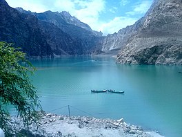 Attabad Lake Gojal, photographed in July 2017 | |
 Attabad Lake Gojal  Attabad Lake Gojal | |
| Location | Gojal, Gilgit-Baltistan, Pakistan |
| Coordinates | 36°20′13″N 74°52′3″E / 36.33694°N 74.86750°E |
| Etymology | Attabad |
| Primary inflows | Hunza River, 79 m3/s (2,800 cu ft/s), 26 May 2010 |
| Primary outflows | Gojal River overflowing landslide dam, 100 m3/s (3,700 cu ft/s), 4 June 2010 |
| Max. length | 21 km (13 mi) |
| Max. depth | 109 m (358 ft) |
| Water volume | 410,000,000 m3 (330,000 acre⋅ft), 26 May 2010 |
| Settlements | Gojal, Hunza Valley |
  Formation editThe genesis of the lake traces back to a landslide in the Attabad village within the Hunza Valley, in Gilgit-Baltistan. On January 4, 2010, a substantial landslide, occurring approximately 14 kilometers (9 miles) upstream to the east of Karimabad, led to the creation of this body of water. The landslide claimed the lives of twenty individuals and triggered the obstruction of the Hunza River's flow for a period of five months. It also resulted in the displacement of around 6,000 residents from villages located upstream, while an additional 25,000 individuals found themselves stranded due to the disruption of land transportation routes.[citation needed] Furthermore, the lake inundated a considerable stretch measuring over 19 kilometers (12 miles) of the Karakoram Highway, a pivotal transportation artery in the region.[citation needed]. The lake reached 21 kilometres (13 mi) long and over 100 metres (330 ft) in depth by the first week of June, 2010, when it began flowing over the landslide dam, completely submerging lower Shishkat and partly flooding Gulmit.[3] The subdivision of Gojal has the greatest number of flooded buildings, over 170 houses, and 120 shops. The residents also had shortages of food and other items due to the blockage of the Karakoram Highway.[4] By 4 June 2010, water outflow from the lake had increased to 100 m3/s (3,700 cu ft/s).[5] The escalation of water levels persisted until June 18, 2010, driven by a disparity between the outflow and inflow dynamics of the newly formed lake. As bad weather continued, the supply of food, medicine and other goods was stopped as all forms of transportation including helicopter service to Hunza could not resume.[6] Aftermath of landslide editVictims of the landslide and expansion of the lake staged a sit-in protesting the lack of government action and compensation payments to them.[7] As a result of the damming of the Hunza River, five villages north of the barrier were flooded. One village, Ayeenabad, was completely submerged. Major portions of another village, Shishkat, was also submerged. Around 40% of the village of Gulmit, which also serves as the headquarters of Gojal Valley, was also submerged. Significant portions of land in Hussaini and Ghulkin villages of Gojal also got submerged as a result of the surging lake. The entire population of the central Hunza and Gojal valleys (Upper Hunza), up to 25,000 individuals, were affected[8] as a result of the lake formation. The challenges stemmed from the impediments posed by road access, hindering the populace from reaching business markets. Additionally, the community endured losses in terms of land, houses, and agricultural yields, further compounding the adverse effects brought about by the lake's emergence. Attabad Lake was visited by the former prime ministers of Pakistan Yousuf Raza Gillani and Nawaz Sharif, and by the Chief Minister of Punjab, Shahbaz Sharif. Sharif announced Rs 100 million of aid for the victims from the Punjab government and Rs 0.5 million for the relatives of those who died in the landslide.[9] Areas downstream from the lake remained on alert[10] despite some officials believing that a major flood scenario was less likely as the river began flowing over the landslide dam during the first week of June 2010.[11] Many people have been evacuated to 195 relief camps. Two hospitals downstream, the Kashrote Eye Vision Hospital and the Aga Khan Health Service,[12] evacuated both their staff and equipment.[9] Some officials had incorrectly predicted that as soon as the lake began flowing over the landslide dam, an 18-metre (60 ft) wave would hit the areas immediately downstream.[13] As of 14 June 2010, the water level continued to rise. Dawn News reported that "242 houses, 135 shops, four hotels, two schools, four factories, and several hundred acres of agricultural land" had been flooded, and that villagers were receiving food and school fee subsidies. They reported that 25 kilometres (16 mi) of the Karakoram Highway and six bridges were destroyed.[14] Frontier Works Organization blasted the spillway of the lake first on 27 March 2012 and then on 15 May 2012, lowering the lake's water level by at least 10 metres (33 ft).[15] Karakoram Highway realignment editPart of Karakoram Highway was submerged due to this landslide. On 14 September 2015, the Prime Minister of Pakistan, Mian Nawaz Sharif, performed the inauguration of the realigned 24 km (15 mi) patch of KKH containing five tunnels at Attabad Barrier Lake. The five tunnels are known as the Pakistan-China Friendship Tunnels, and are collectively seven kilometres (4.3 mi) long. They are part of the 24 km (15 mi) long portion of the Karakoram Highway (KKH) which was damaged in 2010 due to the landslide at Attabad. The realignment project was built at a cost of $275 million. The realignment restored the road link between Pakistan and China and it is expected that a significant amount of trade will be conducted between China and Pakistan using it. The KKH is also a part of the China Pakistan Economic Corridor and is expected to significantly increase economic integration between those two nations.[16] See also edit
References edit
Wikimedia Commons has media related to Attabad Lake. External links edit
| |