


Summary
Attilly is a commune in the department of Aisne in the Hauts-de-France region of northern France.
Attilly | |
|---|---|
Commune | |
 Town hall | |
Location of Attilly .mw-parser-output .locmap .od{position:absolute}.mw-parser-output .locmap .id{position:absolute;line-height:0}.mw-parser-output .locmap .l0{font-size:0;position:absolute}.mw-parser-output .locmap .pv{line-height:110%;position:absolute;text-align:center}.mw-parser-output .locmap .pl{line-height:110%;position:absolute;top:-0.75em;text-align:right}.mw-parser-output .locmap .pr{line-height:110%;position:absolute;top:-0.75em;text-align:left}.mw-parser-output .locmap .pv>div{display:inline;padding:1px}.mw-parser-output .locmap .pl>div{display:inline;padding:1px;float:right}.mw-parser-output .locmap .pr>div{display:inline;padding:1px;float:left}html.skin-theme-clientpref-night .mw-parser-output .od,html.skin-theme-clientpref-night .mw-parser-output .od .pv>div,html.skin-theme-clientpref-night .mw-parser-output .od .pl>div,html.skin-theme-clientpref-night .mw-parser-output .od .pr>div{background:#000;color:#fff}html.skin-theme-clientpref-night .mw-parser-output .locmap{filter:grayscale(0.6)}@media(prefers-color-scheme:dark){html.skin-theme-clientpref-os .mw-parser-output .locmap{filter:grayscale(0.6)}html.skin-theme-clientpref-os .mw-parser-output .od,html.skin-theme-clientpref-os .mw-parser-output .od .pv>div,html.skin-theme-clientpref-os .mw-parser-output .od .pl>div,html.skin-theme-clientpref-os .mw-parser-output .od .pr>div{background:#000;color:#fff}}  Attilly  Attilly | |
| Coordinates: 49°51′27″N 3°10′10″E / 49.8575°N 3.1694°E | |
| Country | France |
| Region | Hauts-de-France |
| Department | Aisne |
| Arrondissement | Saint-Quentin |
| Canton | Saint-Quentin-1 |
| Intercommunality | Pays du Vermandois |
| Government | |
| • Mayor (2020–2026) | Sylvie Belmere[1] |
| Area 1 | 11.81 km2 (4.56 sq mi) |
| Population (2021)[2] | 348 |
| • Density | 29/km2 (76/sq mi) |
| Time zone | UTC+01:00 (CET) |
| • Summer (DST) | UTC+02:00 (CEST) |
| INSEE/Postal code | 02029 /02490 |
| Elevation | 66–141 m (217–463 ft) (avg. 150 m or 490 ft) |
| 1 French Land Register data, which excludes lakes, ponds, glaciers > 1 km2 (0.386 sq mi or 247 acres) and river estuaries. | |
Geography edit
Attilly is located 5 km west of Saint-Quentin just north of the A29 autoroute which passes through the southwestern corner of the commune. It can be accessed by several roads: the D73 from Beauvois-en-Vermandois in the southwest to Villeveque, the D733 from Etreillers in the south going northwest to Villeveque, the D33 going north from Etreillers to Attilly village and continuing north to Marteville and Vermand, the D73 from the D1029 in the north to Marteville, and the D686 from Holnon in the east to the village. There are three villages and hamlets in the commune:[3]
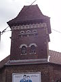
- Attilly in the centre with the town hall, the school (closed), the festival hall, the church, the train station (closed), 25 cafes (all closed), and a water tower
- Marteville in the north with its cemetery, railway station (closed), castle (private) is located next to the village of Vermand
- Villeveque in the west with the villa of the Prince of Monaco, ponds for fishing, and the mill (where it is possible to learn to swim)
Much of the commune is farmland; however, it is partly surrounded by the Forests of Holnon and Attilly.[4]
The Omignon river passes along and forms the northwestern border of the commune through Marteville and Villevèque.[5]
Neighbouring communes and villages edit
History edit
The name Attilly is derived from a word translated as "overlooking the water" and probably owes its name to its position atop a hill.[6] The origin of the name Attilly therefore probably dates back to a Roman villa. However, the region has been inhabited for much longer.[7]
Charles Poette[8] wrote a history at the beginning of the 20th century. The village was destroyed during the First World War: only a single wall was still standing at the end of the conflict on the Rue du Prozet.
Administration edit
This list is incomplete; you can help by adding missing items. (April 2021) |
List of Successive Mayors of Attilly[9]
| From | To | Name | Party |
|---|---|---|---|
| François Vassant | |||
| Georges Lenain | |||
| 1983 | 2008 | Pierre Vassant | |
| 2008 | 2020 | Jean-Paul Bruet | DVG |
| 2020 | Present | Sylvie Belmere[1] |
Population edit
| Year | Pop. | ±% p.a. |
|---|---|---|
| 1968 | 376 | — |
| 1975 | 376 | +0.00% |
| 1982 | 378 | +0.08% |
| 1990 | 401 | +0.74% |
| 1999 | 397 | −0.11% |
| 2007 | 398 | +0.03% |
| 2012 | 376 | −1.13% |
| 2017 | 363 | −0.70% |
| Source: INSEE[10] | ||
Sites and Monuments edit

- The Church of Saint Martin
- The War memorial commemorating the First World War.
- Marteville Communal Cemetery, a British military cemetery managed by the Commonwealth War Graves Commission.
- A Calvary on the road between Attilly and Marteville (Vermand), another between Attilly and Holnon, and another on the road to Etreillers. There is also one at the entrance to the village from the Attilly forest which is located facing the road to Vermand not far from the church
- A Calvary or Wayside Cross on the dirt road towards Etreillers after the water tower at the top of the village.
- A Tomb on the road to Etreillers
- The Place Verte (Green Square) located on the old Roman road between Holnon and Vermand
- The ruins of a Chapel in the middle of Attilly forest where there was an old village abandoned after the First World War
- The Place du Sar (Royal Square) where 14 July is celebrated and where the hall is built
- A Dovecote next to the Rue de l'Eglise.
Picture Gallery edit
-
 Entrance to the town and a Wayside Cross
 -
 The Church of Saint Martin
 -
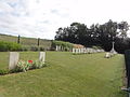 The Marteville Communal Cemetery
 -
 Dugouts in Attilly 2 May 1917
 -
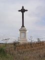 A Wayside Cross
 -
 The Dovecote


Culture edit
The language spoken in Attilly is still a Picard dialect.
See also edit
References edit
- ^ a b "Répertoire national des élus: les maires". data.gouv.fr, Plateforme ouverte des données publiques françaises (in French). 2 December 2020.
- ^ "Populations légales 2021". The National Institute of Statistics and Economic Studies. 28 December 2023.
- ^ Canton of Vermand Map (in French)
- ^ Forests of Holnon and Attilly (in French)
- ^ a b Google Maps
- ^ History of Aisne (in French)
- ^ Fagnart, Jean-Pierre, Industry at Federmesser in the Forests of Holnon at Attilly, Aisne, France, in a North-west European context, 1987 (in French)
- ^ Charles Poette Book (in French)
- ^ List of Mayors of Aisne>
- ^ Population en historique depuis 1968, INSEE
External links edit
- Attilly on Géoportail, National Geographic Institute (IGN) website (in French)
- Attilly on the 1750 Cassini Map