


Summary
Aubange (French pronunciation: [obɑ̃ʒ] ⓘ; German: Ibingen; Luxembourgish: Éibeng; Walloon: Åbindje) is a city and municipality of Wallonia located in the province of Luxembourg, Belgium.
Aubange
Éibeng (Luxembourgish) Ibingen (German) | |
|---|---|
City and municipality | |
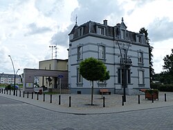 The townhall in Athus | |
 Coat of arms | |
Location of Aubange .mw-parser-output .locmap .od{position:absolute}.mw-parser-output .locmap .id{position:absolute;line-height:0}.mw-parser-output .locmap .l0{font-size:0;position:absolute}.mw-parser-output .locmap .pv{line-height:110%;position:absolute;text-align:center}.mw-parser-output .locmap .pl{line-height:110%;position:absolute;top:-0.75em;text-align:right}.mw-parser-output .locmap .pr{line-height:110%;position:absolute;top:-0.75em;text-align:left}.mw-parser-output .locmap .pv>div{display:inline;padding:1px}.mw-parser-output .locmap .pl>div{display:inline;padding:1px;float:right}.mw-parser-output .locmap .pr>div{display:inline;padding:1px;float:left}html.skin-theme-clientpref-night .mw-parser-output .od,html.skin-theme-clientpref-night .mw-parser-output .od .pv>div,html.skin-theme-clientpref-night .mw-parser-output .od .pl>div,html.skin-theme-clientpref-night .mw-parser-output .od .pr>div{background:#000;color:#fff}html.skin-theme-clientpref-night .mw-parser-output .locmap{filter:grayscale(0.6)}@media(prefers-color-scheme:dark){html.skin-theme-clientpref-os .mw-parser-output .locmap{filter:grayscale(0.6)}html.skin-theme-clientpref-os .mw-parser-output .od,html.skin-theme-clientpref-os .mw-parser-output .od .pv>div,html.skin-theme-clientpref-os .mw-parser-output .od .pl>div,html.skin-theme-clientpref-os .mw-parser-output .od .pr>div{background:#000;color:#fff}}  Aubange Location in Belgium
Location of Aubange in Luxembourg province  | |
| Coordinates: 49°34′N 05°48.3′E / 49.567°N 5.8050°E | |
| Country | |
| Community | French Community |
| Region | Wallonia |
| Province | Luxembourg |
| Arrondissement | Arlon |
| Government | |
| • Mayor | Jean-Paul Dondelinger (cdH) |
| • Governing party/ies | CDH.com - Intérêt Général (IG) |
| Area | |
| • Total | 46.11 km2 (17.80 sq mi) |
| Population (2018-01-01)[1] | |
| • Total | 16,927 |
| • Density | 370/km2 (950/sq mi) |
| Postal codes | 6790-6792 |
| NIS code | 81004 |
| Area codes | 063 |
| Website | www.aubange.be |
On 1 January 2012 the municipality, which covers 45.6 km2, had 16,042 inhabitants, giving a population density of 330.9 inhabitants per km2. It is the third municipality of the Province of Luxembourg regarding the number of inhabitants but it is also among the smallest ones in terms of area.
The municipality is French-speaking but most of which falls within the Luxembourgish-speaking Arelerland, adjoins the tripoint where the borders of Belgium, the Grand Duchy of Luxembourg, and France meet.
The municipality consists of the following districts: Athus, Aubange, Halanzy, and Rachecourt.
History edit
The district of Aubange was a municipality itself before the reorganization of the Belgian municipalities in 1977. Even though the new municipality took the name Aubange, the biggest place is Athus and it is where most of the services and official buildings are, like the townhall, the police station, the fire station, the post office, etc.
Geography edit
Aubange is located in the Lorraine region in the south of Belgium just next to France and the Grand Duchy of Luxembourg.
Subdivisions edit
The municipality consists of the following sub-municipalities: Aubange proper, Athus, Halanzy, and Rachecourt.
Other population centers include: Aix-sur-Cloie, Battincourt, and Guerlange.
Population edit
The following graph represents the growing of the population in the municipality since 1990.[2] The village of Aubange itself contains about 4,000 inhabitants.

Economy edit

For a long time, Aubange has been linked with siderurgy. There were two big factories in Athus and in Halanzy and also a mine. But because of the concurrence of the foreign markets (especially the ones from Asia and Africa), siderurgy as not profitable anymore and all the factories closed one after another in the whole area.
Now the politics have tried to found new ways to develop the economy. One of the most well-known activities is the Railway Containers Terminal of Athus which deals with thousands of containers each year from the big harbors of the North Sea like Antwerp and Rotterdam to the inland of France, Germany or Luxembourg.[3]
Transports edit

Aubange has a short highway: the A28/E411 with two exits: 4 Aubange and 3 Athus. The A28 continues north as the N81 towards Arlon and eventually Brussels. Going south it ends at the French border and continues in France as the N52 towards Longwy and Thionville. Besides the highway, Aubange is also crossed by the major N88 road from the Luxembourg border near Pétange, via Athus, Aubange proper and Halanzy towards Virton and Florenville. In total, the municipality is crossed by the following national roads,[4] mainained by the Walloon Region:
- A28/E411: France (Longwy) - Aubange - Arlon
- N81: Aubange - Arlon
- N88: Luxembourg (Pétange) - Athus - Aubange - Halanzy - Virton - Florenville
- N800: Rachecourt - Musson
- N804: Luxembourg (Rodange) - Aubange
- N813: N88 - Aix-sur-Cloie - Meix-le-Tige - Étalle
- N830/E44: Luxembourg (Pétange) - Athus Container Terminal - France (Mont-Saint-Martin)
- N870: N88 - Halanzy - Rachecourt - Habergy - Arlon
- N872: Luxembourg (Rodange) - Athus
- N883: France (Mont-Saint-Martin) - Aubange - Messancy
The villages of Battincourt and Guerlange are only connected via municipal roads, not via the N-network.
There are 6 border crossings with Luxembourg and 5 with France:
- Rue Albert Claude from neighbouring Messancy to Clemency (LU)
- Rue de la Frontière from Guerlange to Clemency (LU)
- N88 Athus - Pétange (LU)
- N872 Athus - Rodange (LU)
- N830/E44 Athus - Pétange (LU)
- N804 Aubange - Rodange (LU)
- N830/E44 Athus - Mont-Saint-Martin (FR)
- A28/E411 Athus - Mont-Saint-Martin (FR)
- N883 Aubange - Mont-Saint-Martin (FR)
- Rue de l'Ermitage Halanzy - Mont-Saint-Martin (FR)
Aubange is served by the Walloon transport authority TEC with following bus lines:
- 16: Virton - Halanzy - Aubange - Athus - Arlon
- 20: Châtillon - Rachecourt - Arlon
- 21: Battincourt - Aix-sur-Cloie - Aubange - Athus - Arlon
- 83: Virton - Halanzy - Aubange - Luxembourg (LU)
- 161: Virton - Halanzy - Aubange - Athus - Arlon
- 169: Saint-Mard - Halanzy - Aubange - Athus
- 201: Châtillon - Rachecourt - Arlon
- 211: Battincourt - Aix-sur-Cloie - Aubange - Athus - Differt - Stockem
- 212: Rodange (LU) - Athus - Arlon
- 711: Virton - Mussy-la-Ville - Halanzy - Aubange - Athus
- 721: Musson - Rachecourt - Halanzy - Aubange - Athus - Differt
- 722: Bascharage (LU) - Athus - Aubange - Differt
- 731: Saint-Léger - Aubange - Athus
- 741: Arlon - Hondelange - Athus
- 751: Athus - Aubange - Longwy (FR)
- 761: Athus - Guerlange
Besides the Belgian service, Aubange is also served by Luxembourgisch bus service with one line:
- 703: Luxembourg - Pétange - Aubange - Athus - Mont-Saint-Martin (FR)
There are three railway stations in the municipality: in Athus, in Aubange and in Halanzy. The municipality is crossed by railway lines 165 and 167 and is connected by local train service to the provincial capital Arlon and to neighbouring Luxembourg. The municipality has the following train services:[5]
- L-165: Libramont - Bertrix - Virton - Halanzy - Aubange - Athus - Arlon
- L-165: Athus - Rodange (LU) - Luxembourg (LU)
The closest airport to Aubange is Luxembourg Airport, located 38km northeast.
See also edit
References edit
- ^ "Wettelijke Bevolking per gemeente op 1 januari 2018". Statbel. Retrieved 9 March 2019.
- ^ "Chiffres de la population résidente au 1er janvier, par année 1990‑2010". le site de l’INS (in French). Retrieved 11 January 2011..
- ^ "Athus Container Terminal". Official website of Athus Container Terminal. Archived from the original on 2013-10-05..
- ^ "Accueil". geoportail.wallonie.be. Retrieved 2024-02-14.
- ^ NMBS. "Timetable leaflets". Retrieved 14 February 2024.
External links edit
 Media related to Aubange at Wikimedia Commons