
KNOWPIA
WELCOME TO KNOWPIA

Auberville-la-Renault 
Summary
Auberville-la-Renault is a commune in the Seine-Maritime department in the Normandy region in northern France.
Auberville-la-Renault | |
|---|---|
 Coat of arms | |
Location of Auberville-la-Renault .mw-parser-output .locmap .od{position:absolute}.mw-parser-output .locmap .id{position:absolute;line-height:0}.mw-parser-output .locmap .l0{font-size:0;position:absolute}.mw-parser-output .locmap .pv{line-height:110%;position:absolute;text-align:center}.mw-parser-output .locmap .pl{line-height:110%;position:absolute;top:-0.75em;text-align:right}.mw-parser-output .locmap .pr{line-height:110%;position:absolute;top:-0.75em;text-align:left}.mw-parser-output .locmap .pv>div{display:inline;padding:1px}.mw-parser-output .locmap .pl>div{display:inline;padding:1px;float:right}.mw-parser-output .locmap .pr>div{display:inline;padding:1px;float:left}html.skin-theme-clientpref-night .mw-parser-output .od,html.skin-theme-clientpref-night .mw-parser-output .od .pv>div,html.skin-theme-clientpref-night .mw-parser-output .od .pl>div,html.skin-theme-clientpref-night .mw-parser-output .od .pr>div{background:#000;color:#fff}html.skin-theme-clientpref-night .mw-parser-output .locmap{filter:grayscale(0.6)}@media(prefers-color-scheme:dark){html.skin-theme-clientpref-os .mw-parser-output .locmap{filter:grayscale(0.6)}html.skin-theme-clientpref-os .mw-parser-output .od,html.skin-theme-clientpref-os .mw-parser-output .od .pv>div,html.skin-theme-clientpref-os .mw-parser-output .od .pl>div,html.skin-theme-clientpref-os .mw-parser-output .od .pr>div{background:#000;color:#fff}}  Auberville-la-Renault  Auberville-la-Renault | |
| Coordinates: 49°40′56″N 0°22′01″E / 49.6822°N 0.3669°E | |
| Country | France |
| Region | Normandy |
| Department | Seine-Maritime |
| Arrondissement | Le Havre |
| Canton | Saint-Romain-de-Colbosc |
| Intercommunality | CC Campagne Caux |
| Government | |
| • Mayor (2020–2026) | Michel Lemesle[1] |
| Area 1 | 4.96 km2 (1.92 sq mi) |
| Population (2021)[2] | 453 |
| • Density | 91/km2 (240/sq mi) |
| Time zone | UTC+01:00 (CET) |
| • Summer (DST) | UTC+02:00 (CEST) |
| INSEE/Postal code | 76033 /76110 |
| Elevation | 88–124 m (289–407 ft) (avg. 111 m or 364 ft) |
| 1 French Land Register data, which excludes lakes, ponds, glaciers > 1 km2 (0.386 sq mi or 247 acres) and river estuaries. | |
Geography edit
A farming village situated in the Pays de Caux, some 18 miles (29 km) northeast of Le Havre, at the junction of the D68 and the D925.
Heraldry edit
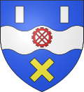 |
The arms of Auberville-la-Renault are blazoned : Azure, on a fess wavy between 2 billets argent and saltire couped Or, a millwheel gules.
|
Population edit
| Year | Pop. | ±% p.a. |
|---|---|---|
| 1968 | 262 | — |
| 1975 | 291 | +1.51% |
| 1982 | 294 | +0.15% |
| 1990 | 347 | +2.09% |
| 1999 | 347 | +0.00% |
| 2007 | 388 | +1.41% |
| 2012 | 451 | +3.05% |
| 2017 | 462 | +0.48% |
| Source: INSEE[3] | ||
Places of interest edit
See also edit
References edit
- ^ "Répertoire national des élus: les maires". data.gouv.fr, Plateforme ouverte des données publiques françaises (in French). 2 December 2020.
- ^ "Populations légales 2021". The National Institute of Statistics and Economic Studies. 28 December 2023.
- ^ Population en historique depuis 1968, INSEE
Wikimedia Commons has media related to Auberville-la-Renault.