


Summary
Auchel (French pronunciation: [oʃɛl]; Picard: Auchez) is a commune in the Pas-de-Calais department in the Hauts-de-France region in northern France.
Auchel | |
|---|---|
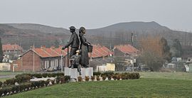 The mining memorial | |
Location of Auchel .mw-parser-output .locmap .od{position:absolute}.mw-parser-output .locmap .id{position:absolute;line-height:0}.mw-parser-output .locmap .l0{font-size:0;position:absolute}.mw-parser-output .locmap .pv{line-height:110%;position:absolute;text-align:center}.mw-parser-output .locmap .pl{line-height:110%;position:absolute;top:-0.75em;text-align:right}.mw-parser-output .locmap .pr{line-height:110%;position:absolute;top:-0.75em;text-align:left}.mw-parser-output .locmap .pv>div{display:inline;padding:1px}.mw-parser-output .locmap .pl>div{display:inline;padding:1px;float:right}.mw-parser-output .locmap .pr>div{display:inline;padding:1px;float:left}html.skin-theme-clientpref-night .mw-parser-output .od,html.skin-theme-clientpref-night .mw-parser-output .od .pv>div,html.skin-theme-clientpref-night .mw-parser-output .od .pl>div,html.skin-theme-clientpref-night .mw-parser-output .od .pr>div{background:#000;color:#fff}html.skin-theme-clientpref-night .mw-parser-output .locmap{filter:grayscale(0.6)}@media(prefers-color-scheme:dark){html.skin-theme-clientpref-os .mw-parser-output .locmap{filter:grayscale(0.6)}html.skin-theme-clientpref-os .mw-parser-output .od,html.skin-theme-clientpref-os .mw-parser-output .od .pv>div,html.skin-theme-clientpref-os .mw-parser-output .od .pl>div,html.skin-theme-clientpref-os .mw-parser-output .od .pr>div{background:#000;color:#fff}}  Auchel  Auchel | |
| Coordinates: 50°30′31″N 2°28′28″E / 50.5086°N 2.4744°E | |
| Country | France |
| Region | Hauts-de-France |
| Department | Pas-de-Calais |
| Arrondissement | Béthune |
| Canton | Auchel |
| Intercommunality | CA Béthune-Bruay, Artois-Lys Romane |
| Government | |
| • Mayor (2020–2026) | Phillibert Berrier[1] |
| Area 1 | 6 km2 (2 sq mi) |
| Population (2021)[2] | 10,062 |
| • Density | 1,700/km2 (4,300/sq mi) |
| Time zone | UTC+01:00 (CET) |
| • Summer (DST) | UTC+02:00 (CEST) |
| INSEE/Postal code | 62048 /62260 |
| Elevation | 68–157 m (223–515 ft) (avg. 99 m or 325 ft) |
| 1 French Land Register data, which excludes lakes, ponds, glaciers > 1 km2 (0.386 sq mi or 247 acres) and river estuaries. | |
Geography edit
An ex-mining town, nowadays a light industrial & farming commune, situated 8 miles (13 km) southwest of Béthune and 34 miles (55 km) southwest of Lille, at the junction of the D183 and the D183E roads.
History edit
Following the discovery of coal deposits in the area in 1851, the town grew as the demand for
coal increased in France. This old mining town had close to 15,000 inhabitants in the 1950s.
The coal recession in the late 1960s lead to a constant decline in population, despite the efforts of the municipality to attract and keep people here during and after the recession.
Population edit
The inhabitants are called Auchellois.
| Year | Pop. | ±% p.a. |
|---|---|---|
| 1968 | 14,091 | — |
| 1975 | 13,329 | −0.79% |
| 1982 | 12,535 | −0.87% |
| 1990 | 11,813 | −0.74% |
| 1999 | 11,392 | −0.40% |
| 2007 | 11,225 | −0.18% |
| 2012 | 10,991 | −0.42% |
| 2017 | 10,291 | −1.31% |
| Source: INSEE[3] | ||
Sights edit
- The church of St. Martin, dating from the sixteenth century.
- A museum about coal mining.
International relations edit
Auchel is twinned with:
 West Malling, in the county of Kent, England.
 Iserlohn, in North Rhine-Westphalia, Germany.
Notable people edit
Auchel is the birthplace of:
- Xavier Beauvois, actor, director and screenwriter.
- Angela Behelle, writer
- Pierre Laigle, football player
- Augustin Lesage, French spiritualist artist. Lesage is one of the most fascinating figures associated with Art Brut
- Stéphane Lecocq, professional footballer
- Fred Personne, actor
- Afida Turner, singer, songwriter, actress, and media personality
- Pierre Waché, Formula One engineer and technical director for Red Bull Racing
See also edit
References edit
- ^ "Répertoire national des élus: les maires" (in French). data.gouv.fr, Plateforme ouverte des données publiques françaises. 13 September 2022.
- ^ "Populations légales 2021". The National Institute of Statistics and Economic Studies. 28 December 2023.
- ^ Population en historique depuis 1968, INSEE
External links edit
- An history of Auchel (in French)
- Harmonie municipale website (in French)
- Auchel town hall website (in French)