
KNOWPIA
WELCOME TO KNOWPIA

Auderville 
Summary
Auderville (French pronunciation: [odɛʁvil]) is a former commune on the north coast of the Manche department in the Normandy region in northwestern France. On 1 January 2017, it was merged into the new commune La Hague.[2]
Auderville | |
|---|---|
Part of La Hague | |
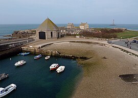 The port | |
Location of Auderville .mw-parser-output .locmap .od{position:absolute}.mw-parser-output .locmap .id{position:absolute;line-height:0}.mw-parser-output .locmap .l0{font-size:0;position:absolute}.mw-parser-output .locmap .pv{line-height:110%;position:absolute;text-align:center}.mw-parser-output .locmap .pl{line-height:110%;position:absolute;top:-0.75em;text-align:right}.mw-parser-output .locmap .pr{line-height:110%;position:absolute;top:-0.75em;text-align:left}.mw-parser-output .locmap .pv>div{display:inline;padding:1px}.mw-parser-output .locmap .pl>div{display:inline;padding:1px;float:right}.mw-parser-output .locmap .pr>div{display:inline;padding:1px;float:left}html.skin-theme-clientpref-night .mw-parser-output .od,html.skin-theme-clientpref-night .mw-parser-output .od .pv>div,html.skin-theme-clientpref-night .mw-parser-output .od .pl>div,html.skin-theme-clientpref-night .mw-parser-output .od .pr>div{background:#000;color:#fff}html.skin-theme-clientpref-night .mw-parser-output .locmap{filter:grayscale(0.6)}@media(prefers-color-scheme:dark){html.skin-theme-clientpref-os .mw-parser-output .locmap{filter:grayscale(0.6)}html.skin-theme-clientpref-os .mw-parser-output .od,html.skin-theme-clientpref-os .mw-parser-output .od .pv>div,html.skin-theme-clientpref-os .mw-parser-output .od .pl>div,html.skin-theme-clientpref-os .mw-parser-output .od .pr>div{background:#000;color:#fff}}  Auderville  Auderville | |
| Coordinates: 49°42′46″N 1°55′48″W / 49.7128°N 1.93°W | |
| Country | France |
| Region | Normandy |
| Department | Manche |
| Arrondissement | Cherbourg |
| Canton | La Hague |
| Commune | La Hague |
| Area 1 | 4.33 km2 (1.67 sq mi) |
| Population (2019)[1] | 215 |
| • Density | 50/km2 (130/sq mi) |
| Time zone | UTC+01:00 (CET) |
| • Summer (DST) | UTC+02:00 (CEST) |
| Postal code | 50440 |
| Elevation | 0–133 m (0–436 ft) (avg. 60 m or 200 ft) |
| 1 French Land Register data, which excludes lakes, ponds, glaciers > 1 km2 (0.386 sq mi or 247 acres) and river estuaries. | |
History edit
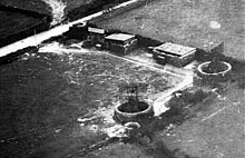
On 22 February 1941, an RAF reconnaissance Spitfire aircraft from RAF Benson in south Oxfordshire with Flying Officer William Kenneth Manifould (28 June 1918 - 10 April 1941) of No. 1 Photographic Reconnaissance Unit RAF spotted the Freya radar nearby.[3]
Geography edit
The commune contains four villages, Goury, Laye, La Valette and La Roche, as well as a lighthouse. It is separated from Alderney by the Raz Blanchard, and has a small and not easily accessible port at Goury.
Population edit
|
|
Heraldry edit
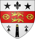 |
The arms of Auderville are blazoned : Argent, on a fess gules in pale 2 leopards between 2 buckles Or, in chief a fleur de lys between 2 mullets, and in base a lighthouse between 2 ermine spots sable, the lighthouse pierced of the field and lit Or.
|
See also edit
References edit
Wikimedia Commons has media related to Auderville.