


Summary
Auer (German pronunciation: [ˈaʊ̯ɐ]; Italian: Ora [ˈɔːra]) is a comune (municipality) and a village in South Tyrol in northern Italy, located about 15 kilometres (9 mi) south of the city of Bolzano.
Auer | |
|---|---|
| Marktgemeinde Auer Comune di Ora | |
 | |
Location of Auer .mw-parser-output .locmap .od{position:absolute}.mw-parser-output .locmap .id{position:absolute;line-height:0}.mw-parser-output .locmap .l0{font-size:0;position:absolute}.mw-parser-output .locmap .pv{line-height:110%;position:absolute;text-align:center}.mw-parser-output .locmap .pl{line-height:110%;position:absolute;top:-0.75em;text-align:right}.mw-parser-output .locmap .pr{line-height:110%;position:absolute;top:-0.75em;text-align:left}.mw-parser-output .locmap .pv>div{display:inline;padding:1px}.mw-parser-output .locmap .pl>div{display:inline;padding:1px;float:right}.mw-parser-output .locmap .pr>div{display:inline;padding:1px;float:left}html.skin-theme-clientpref-night .mw-parser-output .od,html.skin-theme-clientpref-night .mw-parser-output .od .pv>div,html.skin-theme-clientpref-night .mw-parser-output .od .pl>div,html.skin-theme-clientpref-night .mw-parser-output .od .pr>div{background:#000;color:#fff}html.skin-theme-clientpref-night .mw-parser-output .locmap{filter:grayscale(0.6)}@media(prefers-color-scheme:dark){html.skin-theme-clientpref-os .mw-parser-output .locmap{filter:grayscale(0.6)}html.skin-theme-clientpref-os .mw-parser-output .od,html.skin-theme-clientpref-os .mw-parser-output .od .pv>div,html.skin-theme-clientpref-os .mw-parser-output .od .pl>div,html.skin-theme-clientpref-os .mw-parser-output .od .pr>div{background:#000;color:#fff}}  Auer Location of Auer in Italy  Auer Auer (Trentino-Alto Adige/Südtirol) | |
| Coordinates: 46°21′N 11°18′E / 46.350°N 11.300°E | |
| Country | Italy |
| Region | Trentino-Alto Adige/Südtirol |
| Province | South Tyrol (BZ) |
| Government | |
| • Mayor | Martin Feichter |
| Area | |
| • Total | 11.8 km2 (4.6 sq mi) |
| Elevation | 236 m (774 ft) |
| Population (Dec. 2015)[2] | |
| • Total | 3,648 |
| • Density | 310/km2 (800/sq mi) |
| Demonyms | German: Auer Italian: orensi |
| Time zone | UTC+1 (CET) |
| • Summer (DST) | UTC+2 (CEST) |
| Postal code | 39040 |
| Dialing code | 0471 |
| Website | Official website |
Geography edit
As of 31 December 2015, it had a population of 3,648 and an area of 11.8 square kilometres (4.6 sq mi).[3]
Auer borders the following municipalities: Aldein, Bronzolo, Montan and Vadena.
History edit
The name of the settlement is firstly mentioned in a deed of 1190 written in latin which names Conradinus de Aura, a servant of the Enn noblemen.[4]
The village of Auer emerged as an association of people as early as the 15th century, as a corresponding document from 1463 attests with the explicit naming of the "comunitas ville Awer" – the community of the village of Auer – and its Riegler (land managers).[5]
In 2022, two Stolpersteine have been laid for Martin Krebs and Ida Kaufmann, both local victims of the Holocaust during the Operationszone Alpenvorland period of 1943/44.[6]
Coat of arms edit
The shield is party per fess of argent and gules with an azure chief with a rampant lion. It is the emblem of the family Khuen who took possession of the site, from 1397 until 1690, when they were then elevated to the Imperial Counts. On the azure chief two crossed or keys are represented as a remembrance of the insignia of St. Peter, to whom the parish church is dedicated. The emblem was adopted in 1969.[7]
Society edit
Linguistic distribution edit
According to the 2011 census, 69.74% of the population speak German, 29.59% Italian and 0.67% Ladin as first language.[8]
|
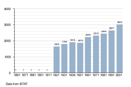
Demographic evolution edit
References edit
- ^ "Superficie di Comuni Province e Regioni italiane al 9 ottobre 2011". Italian National Institute of Statistics. Retrieved 16 March 2019.
- ^ "Popolazione Residente al 1° Gennaio 2018". Italian National Institute of Statistics. Retrieved 16 March 2019.
- ^ All demographics and other statistics: Italian statistical institute Istat.
- ^ Franz Huter 1939). Tiroler Urkundenbuch. I. Abteilung: Die Urkunden zur Geschichte des deutschen Etschlandes und des Vintschgaus. Band 1. Hrsg. vom Tiroler Landesmuseum Ferdinandeum. Innsbruck: Universitätsverlag Wagner. p. 252, no. 458.
- ^ Hannes Obermair (2008). Bozen Süd – Bolzano Nord. Schriftlichkeit und urkundliche Überlieferung der Stadt Bozen bis 1500. Vol. 2. Bozen-Bolzano: Stadtgemeinde Bozen. p. 130, no. 1089a. ISBN 978-88-901870-1-8.
- ^ Bildungsausschuss Auer, January 12, 2022.
- ^ Heraldry of the World: Auer
- ^ a b "Volkszählung 2011/Censimento della popolazione 2011". astat info (38). Provincial Statistics Institute of the Autonomous Province of South Tyrol: 6–7. June 2012. Retrieved 2012-06-14.
- ^ Oscar Benvenuto (ed.): "South Tyrol in Figures 2008", Provincial Statistics Institute of the Autonomous Province of South Tyrol, Bozen/Bolzano 2007, p. 16, table 10
External links edit
![]() Media related to Auer, South Tyrol at Wikimedia Commons
Media related to Auer, South Tyrol at Wikimedia Commons
- (in German and Italian) Homepage of the municipality