


Summary
Avery is a small unincorporated community in the northwest United States, located in the St. Joe River Valley in Shoshone County, Idaho. Avery is located in the middle of the St. Joe District of the Idaho Panhandle National Forest, and is a tourist attraction in the Idaho Panhandle known for its wilderness and outdoor recreation.[citation needed] It is upstream and east of St. Maries, the county seat of Benewah County.
Avery, Idaho | |
|---|---|
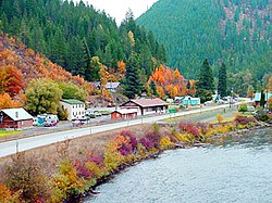 Avery and St. Joe River in the fall | |
 Avery  Avery | |
| Coordinates: 47°15′00″N 115°48′07″W / 47.25°N 115.802°W | |
| Country | United States |
| State | Idaho |
| County | Shoshone |
| Elevation | 2,486 ft (758 m) |
| Population (2000) | |
| • Total | 25 |
| Time zone | UTC-8 (Pacific Time Zone) |
| • Summer (DST) | UTC-7 |
| ZIP code | 83802[2] |
| Area code | 208 |

Geography edit
Avery is located at a latitude of 47.25 ºN, longitude 115.81 ºW, and an elevation of 2562 ft (781m) above sea level.[3]
Climate edit
This climatic region is typified by large seasonal temperature differences, with warm to hot (and often humid) summers and cold (sometimes severely cold) winters. According to the Köppen Climate Classification system, Avery has a humid continental climate, abbreviated "Dfb" on climate maps.[4]
Demographics edit
As of 2013, Avery had a population of 25 permanent residents.[5] The temporary population is higher in the summer though due to seasonal workers for the United States Forest Service and the many summer homes in Avery and along the St. Joe River.[citation needed]. The small population is served by the Avery School District, also serving Calder, Idaho and Clarkia, Idaho.[6]
History edit
The town was from the years 1909 to 1980 a division point on the Pacific Extension of the Chicago, Milwaukee, St. Paul and Pacific Railroad ("Milwaukee Road"). It was also once the western terminus for the easternmost of two electrified mountain sections on the route; the other ran in Washington from Othello, through the Cascade Range to the Puget Sound. Electric operations ran from 1914–74 on this section east to Harlowton, Montana. Trains stopped at the Avery Depot, now listed on the National Register of Historic Places. Here, steam or diesel locomotives were changed or hooked up to electric locomotives.[citation needed]
During the Great Fire of 1910, a 28-man firefighting team died near Setzer Creek outside of Avery.[7] The U.S. Army's 25th Infantry Regiment (known as the Buffalo Soldiers) helped build a back fire that saved Avery.[8] During the fire, many found refuge in the newly-constructed railroad tunnels between Avery and the St. Paul Pass Tunnel (a.k.a. Taft Tunnel) to the northeast.
Avery's population was 450 in 1960.[9]
With ongoing financial problems which worsened in the 1970s, the Milwaukee Road abandoned its right-of-way in the West in 1980, but the tunnels and grades east of Avery are now a rail trail route for hikers and bicyclists, the Route of the Hiawatha Trail.[10]
Recreation edit
Common activities include nature photography, camping, hunting, ATV riding, snowmobiling, hiking, horseback riding, mountain biking, fishing, and rafting.[citation needed]
Attractions edit
The main attraction in Avery is the Fish Pond. All year long, tourists can purchase a handful of fish food for twenty-five cents and watch as the massive rainbow trout leap out of the water to get a bite to eat.[11][tone]
References edit
- ^ U.S. Geological Survey Geographic Names Information System: USGS Place names
- ^ "Avery ZIP Code". zipdatamaps.com. 2022. Retrieved November 11, 2022.
- ^ "Map Avery - Idaho Longitude, Altitude - Sunset". www.usclimatedata.com. Retrieved October 26, 2020.
- ^ Climate Summary for Avery, Idaho
- ^ Robinson, Jessica (September 9, 2013). "Avery, Idaho Struggles To Keep Its Remaining 25 Residents And Its Spot On The Map". Boise State Public Radio. Retrieved February 17, 2014.
- ^ "Avery School District". Avery School District 394. Retrieved March 21, 2022.
- ^ Pyne, Stephen J. (2008). Year of the Fires: The Story of the Great Fires of 1910. Missoula, Montana: Mountain Press Publishing Company. pp. 155–157, 175–176. ISBN 978-0-87842-544-0.
- ^ "The Big Burn-Transcript". American Experience. PBS. February 3, 2015. Retrieved January 23, 2019.
- ^ World Book Encyclopedia. Vol. I. Field Enterprises Corporation. 1960. p. 27.
- ^ "Trail map". Route of the Hiawatha. Retrieved January 31, 2018.
- ^ Kaminsky, Stephen (May 20, 2003). "Get hooked in Avery". The Argonaut. University of Idaho. Archived from the original on February 14, 2006. Retrieved February 17, 2014.