
KNOWPIA
WELCOME TO KNOWPIA

Aves Ridge 
Summary
14°00′N 63°30′W / 14°N 63.5°W
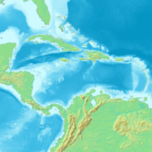
The Aves Ridge is a ridge in the eastern Caribbean Sea. It runs in a north-south direction, approximately 250 km west of the Lesser Antilles Volcanic Arc. It is mostly under water, but it reaches the surface in the north as Aves Island and in the south as La Blanquilla Island.[1][2] Most geologists believe that the Aves Ridge originated as a volcanic arc which is now extinct, though its width poses a problem;[3] the date of its origin is generally placed in the Cretaceous.[4][5]
References edit
- ^ "Isla Blanquilla, Venezuela: Image of the Day". NASA. 26 November 2007. Archived from the original on 25 April 2009.
- ^ James, Keith L. "The Caribbean Ocean Plateau – an overview, and a different understanding" (PDF). pp. 2, 4. Archived (PDF) from the original on 3 October 2008.
- ^ Westbrook, G.K; Biju-Duval, B.; Mascle, A. (September 20, 1983). "Geophysics and the Structure of the Lesser Antilles Forearc" (PDF). Deep Sea Drilling Project. Retrieved 22 September 2017.
- ^ James, Keith H. (2007). "The Caribbean Ocean Plateau – an overview, and a different understanding" (PDF). MantlePlumes.org. Retrieved 22 September 2017.
- ^ Bally, Albert W.; Palmer, Allison R., eds. (1989). Geology of North America—An Overview. Boulder, Colorado: Geological Society of America. p. 314. ISBN 9780813754451.