


Summary
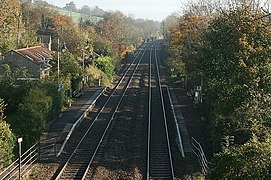
Avoncliff railway station serves the small village of Avoncliff in Wiltshire, England, together with the nearby villages of Westwood and Winsley, and Turleigh hamlet. It is next to the Kennet and Avon Canal and almost adjacent to the Avoncliff Aqueduct, so it is popular with walkers and cyclists who wish to travel along the canal path or the picturesque walks around the station.[1]
Avoncliff | |
|---|---|
 | |
| General information | |
| Location | Avoncliff, Wiltshire England |
| Coordinates | 51°20′22″N 2°16′56″W / 51.3395°N 2.2821°W |
| Grid reference | ST804600 |
| Managed by | Great Western Railway |
| Platforms | 2 |
| Other information | |
| Station code | AVF |
| Classification | DfT category F2 |
| History | |
| Original company | Great Western Railway |
| Key dates | |
| 9 July 1906 | Station opens as Avoncliff Halt |
| 5 May 1969 | Station renamed Avoncliff |
| Passengers | |
| 2018/19 | |
| 2019/20 | |
| 2020/21 | |
| 2021/22 | |
| 2022/23 | |
| Notes | |
Passenger statistics from the Office of Rail and Road | |
The station has two platforms, each long enough for 1+1⁄2 coaches,[2] with a waiting shelter and original lamp-posts, and is served by Great Western Railway. Residents have voluntarily decorated the station with pots of flowers and, to mark its 100-year anniversary on 9 July 2006, decorated the station with bunting and dressed in Victorian clothing for the celebrations.[3]
History edit
Opened on the Wessex Main Line by the Great Western Railway as Avoncliff Halt on 9 July 1906, it remained part of that company during the Grouping of 1923. The station then passed to the Western Region of British Railways on nationalisation in 1948.
Avoncliff Halt escaped closure in the 1960s during the Beeching cuts, despite being listed for closure in the 1963 report "The Reshaping of British Railways".[4]
The suffix 'Halt' was dropped from 5 May 1969.[5]
When sectorisation was introduced in the 1980s, the station was served by Regional Railways until the privatisation of British Railways. The station was a request stop until July 2010, when all stops became mandatory.[citation needed]
Services edit
A generally hourly service is provided by Great Western Railway, northbound to Bath and Bristol and southbound to Bradford on Avon, Trowbridge and Westbury, with some trains continuing to Weymouth and Southampton. The service is less frequent on Sundays.[6]
Other GWR services pass through the station but do not stop.[6]
| Preceding station | Following station | |||
|---|---|---|---|---|
| Freshford | Great Western Railway Heart of Wessex Line |
Bradford-on-Avon | ||
Gallery edit
-
 Station seen from the Avoncliff Aqueduct in 2007
 -
 Bradford-bound platform seen from opposite
 -
 Preserved GWR seat and old station sign
 -
 Access to station seen from platform


References edit
- ^ Ordnance Survey 2015
- ^ Yonge & Padgett 2010, map 4C
- ^ "Avoncliff Halt". Bradford on Avon Museum. Retrieved 7 February 2021.
- ^ "The Reshaping of British Railways: Part I: Report" (PDF). railwaysarchive.co.uk. 1963. p. 108. Retrieved 17 November 2023.
- ^ Butt 1995, p. 22
- ^ a b "Timetable B1 - Cardiff, Bristol, Bath Spa and Swindon to the South Coast" (PDF). Great Western Railway. Archived (PDF) from the original on 24 September 2018. Retrieved 24 September 2018.
Bibliography edit
- Butt, R. V. J. (October 1995). The Directory of Railway Stations: details every public and private passenger station, halt, platform and stopping place, past and present (1st ed.). Sparkford: Patrick Stephens Ltd. ISBN 978-1-85260-508-7. OCLC 60251199. OL 11956311M.
- Jowett, Alan (2000). Jowett's Nationalised Railway Atlas (1st ed.). Penryn, Cornwall: Atlantic Transport Publishers. ISBN 978-0-906899-99-1. OCLC 228266687.
- Jowett, Alan (March 1989). Jowett's Railway Atlas of Great Britain and Ireland: From Pre-Grouping to the Present Day (1st ed.). Sparkford: Patrick Stephens Ltd. ISBN 978-1-85260-086-0. OCLC 22311137.
- OS Explorer Map 156 - Chippenham & Bradford-on-Avon (Map). 1:50,000. Ordnance Survey. 2015. ISBN 9780319243497.
- Yonge, John; Padgett, David (2010) [1989]. Bridge, Mike (ed.). Railway Track Diagrams 3: Western (5th ed.). Bradford on Avon: Trackmaps. ISBN 978-0-9549866-6-7.
External links edit
- Station on navigable O.S. map