
KNOWPIA
WELCOME TO KNOWPIA

Ayn al-Arab District 
Summary
`Ain al-`Arab District (Arabic: منطقة عين العرب, romanized: manṭiqat ‘Ayn al-‘Arab) is a district of Aleppo Governorate in northern Syria. The administrative centre is the city of Kobani.
Ayn al-Arab District
منطقة عين العرب | |
|---|---|
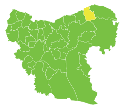
 Location of Ayn al-Arab District within Aleppo Governorate | |
 Ayn al-Arab District Location in Syria | |
| Coordinates (Kobani): 36°53′N 38°22′E / 36.89°N 38.37°E | |
| Country | |
| Governorate | Aleppo |
| Seat | Kobani |
| Subdistricts | 4 nawāḥī |
| Area | |
| • Total | 3,068.04 km2 (1,184.58 sq mi) |
| Population (2004)[1] | 192,513 |
| Geocode | SY0206 |

The administrative center of Ayn al-Arab Subdistrict shown above is the city of Kobani.
The administrative center of Shuyukh Tahtani Subdistrict shown above is the city of Shuyukh Tahtani.
The administrative center of Sarrin Subdistrict shown above is the city of Sarrin.
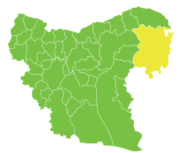
The district fills the northeastern section of the governorate, and its northern boundary is along the Syria–Turkey border.
At the 2004 census, the district had a population of 192,513.[1]
Sub-districts edit
The district of Ayn Al-Arab is divided into four sub-districts or nawāḥī (population as of 2004):
| Code | Name | Area | Population | Seat |
|---|---|---|---|---|
| SY020600 | Ayn al-Arab Subdistrict | 745.60 km2 | 81,424 | Ayn al-Arab |
| SY020601 | Shuyukh Tahtani Subdistrict | 318.86 km2 | 43,861 | Shuyukh Tahtani |
| SY020602 | Sarrin Subdistrict | 2,003.57 km2 | 69,931 | Sarrin |
| Al-Jalabiyah Subdistrict | Al-Jalabiyah |
Al-Jalabiyah Subdistrict was separated from Sarrin Subdistrict in 2009.[2]
References edit
- ^ a b "General Census of Population and Housing 2004" (PDF) (in Arabic). Syrian Central Bureau of Statistics. Archived from the original (PDF) on 8 December 2015. Retrieved 15 October 2015. Also available in English: "2004 Census Data". UN OCHA. Retrieved 15 October 2015.
- ^ "احداث منطقتي دير حافر والاتارب تعزيزاً لمسيرة التنمية". Al-Jamahir (in Arabic). Aleppo. 25 February 2009. Archived from the original on 13 December 2017. Retrieved 25 January 2016.