


Summary
The BMT Jamaica Line, also known as the Broadway - Brooklyn Line, is an elevated rapid transit line of the B Division of the New York City Subway, in Brooklyn and Queens, New York City, United States. It runs from the Williamsburg Bridge southeast over Broadway to East New York, Brooklyn, and then east over Fulton Street and Jamaica Avenue to Jamaica, Queens. In western Jamaica, the line goes into a tunnel, becoming the lower level of the Archer Avenue lines in central Jamaica. The J and Z trains serve the entire length of the Jamaica Line, and the M serves the line west of Myrtle Avenue.
| BMT Jamaica Line | |
|---|---|
   | |
| Overview | |
| Owner | City of New York |
| Termini | |
| Stations | 22 |
| Service | |
| Type | Rapid transit |
| System | New York City Subway |
| Operator(s) | New York City Transit Authority |
| Daily ridership | 62,060[1] |
| History | |
| Opened | 1885-1918 |
| Technical | |
| Number of tracks | 2-3 |
| Character | Elevated |
| Track gauge | 4 ft 8+1⁄2 in (1,435 mm) |
| Electrification | 600V DC third rail |
The longest elevated line in the system, the Jamaica Line includes the oldest existing elevated structure in the system – the original 1885 line of the Brooklyn Elevated Railroad, the former BMT Lexington Avenue Line between Gates Avenue and Van Siclen Avenue – as well as the newest elevated structure, the 1988 ramp into the Archer Avenue subway.
The Brooklyn–Manhattan Transit Corporation (BMT) originally operated the line with "westbound" trains heading toward Manhattan and "eastbound" trains heading toward Canarsie, Middle Village, or Jamaica, generally in agreement with compass direction. However, NYCT's railroad directions, which are north and south, replaced the BMT's west and east railroad directions, respectively. This reclassification resulted in services which ran through the BMT Nassau Street Line to Downtown Brooklyn having two south ends. To eliminate any confusion, the directions of train services in the eastern division were switched, with trains running towards Jamaica being considered Northbound.[2][3] The KK (later K) and current M services were an exception to this, with Jamaica, Broadway Junction, or Metropolitan Avenue remaining the south terminal, since they used the Chrystie Street Connection from the Jamaica Line to the IND Sixth Avenue Line.
Description edit
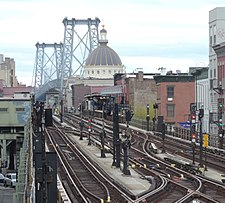
The Jamaica Line includes a variety of structures. The original BMT Jamaica Line started from Broadway Ferry, Brooklyn. The line was two tracks, and connected with Marcy Avenue, from the west. This section, which was called the "Broadway Spur", has a short, but easily seen remnant (about one-half of a block in length, no tracks, just maintenance buildings) west and south of where the line curves toward the Williamsburg Bridge.[3]
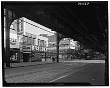
From Marcy Avenue to a point just before Alabama Avenue the line operates on the structure of old elevated railways, but substantially rebuilt and upgraded to a three-track line around 1916 under the Dual Contracts of 1913. The section between Gates Avenue and Van Siclen Avenue was completed in 1885 as part of the BMT Lexington Avenue Line. From Alabama Avenue to just before the current Cypress Hills station, the Jamaica Line operates on the oldest elevated structure in New York City, a steel-reinforced cast iron line opened in 1893. East of Broadway Junction, a third middle trackway exists and elevates over the other two tracks, ending just west of the Alabama Avenue station. This track was intended to be an express track,[4] but engineering studies completed after the work started indicated that the vibration of trains passing over the stations would be too severe and would literally shake the stations apart.
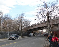
Between Crescent Street station and Cypress Hills, the line runs on an "S-curve", turning north from Fulton Street onto Crescent Street, then east onto Jamaica Avenue. The curves are at nearly 90-degree angles, forcing trains to drastically reduce speed to 15 miles per hour in order to traverse them.[3][5][6] The line east of Cypress Hills is known as the Jamaica Avenue Line, the newest section of the line which was built under the Dual Contracts. This structure has provisions on its entire length for three tracks,[7][8][9] but a center track was never built (see below), with the exception of a layup track at 111th Street[3] and another between 160th Street and 168th Street on the now-demolished original end of the line.
Four curves on the line, including the two on the Jamaica Avenue "S-curve", are among the 30 sharpest curves in the subway system. The curve west of Marcy Avenue has radii of 175 and 190 feet (53 and 58 m) for Manhattan- and Queens-bound trains, respectively. The curve from Broadway Junction to Alabama Avenue has a radius of 175 feet (53 m). The curve east of Crescent Street has radii of 175 and 180 feet (53 and 55 m) and the curve west of Cypress Hills has radii of 210 and 200 feet (64 and 61 m), both respectively for Manhattan- and Queens-bound trains.[5]: 55 As with other BMT Eastern Division lines, the Jamaica Line can only accommodate trains with eight 60-foot-long (18 m) or eight 67-foot-long (20 m) cars. Due to the narrow turning radiuses of the lines, 75-foot-long (23 m) cars (R44, R46, R68, R68A) could not be used on the Eastern Division.[5]: 57
History edit
The Union Elevated Railroad, leased to the Brooklyn Elevated Railroad, opened an elevated line above Broadway from Gates Avenue northwest to Driggs Avenue in Williamsburg on June 25, 1888.[10] This was a branch of the existing Lexington Avenue Elevated, which then ended at Van Siclen Avenue; Broadway trains ran between Driggs and Van Siclen Avenues.[11] A popular free transfer was available at Gates Avenue to Lexington Avenue trains towards Downtown Brooklyn.[12] The Broadway Elevated was extended to Broadway Ferry on July 14, 1888.[13]
An extension of the Broadway Elevated east to Cypress Hills, over Fulton Street and Crescent Street, opened on May 30, 1893,[11] and the company extended both Lexington Avenue and Broadway trains to the new terminal.[11] This extension incorporated portions of the recently demolished Park Avenue Elevated.[14] On May 30, 1903, a connection between the Broadway Elevated and trolley tracks was completed south of the Cypress Hills terminal. Known as the Cypress Hills Incline, it allowed trains to run to 168th Street in Jamaica via Jamaica Avenue. This service was discontinued on December 30, 1903, due to traffic congestion in Jamaica.[15]
A connection to the Williamsburg Bridge was established in 1908, rendering the two westernmost stations on the Broadway Ferry Branch obsolete. These two stations were closed on July 3, 1916. The eastern extension along Jamaica Avenue to 168th Street was opened on July 3, 1918.[7][16]
Joint service with the Long Island Rail Road's Atlantic Branch existed between Norwood Avenue and Crescent Street stations with a connection built at Chestnut Street in Brooklyn. This allowed BRT trains to access the Rockaways and Manhattan Beach, while affording the LIRR a connection into Manhattan to the BRT terminal located at Park Row over the Brooklyn Bridge (this service predated the opening of the East River Tunnels to Penn Station). This service ended in 1917 when the United States Railroad Administration took over the LIRR, and classified different operating standards between rapid transit trains and regular heavy rail railroads such as the LIRR.[17]: 59 In Fiscal Year 1930, the platforms at Kosciuszko Street were lengthened to accommodate an eight-car train of Standard subway cars.[18]
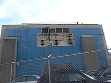
By the time the Independent Subway System extended the Queens Boulevard Line along Hillside Avenue in Jamaica in 1937, residents became dissatisfied with the Jamaica Elevated. Construction of the Archer Avenue subway lines began in 1973. However, the city was hit by a major financial crisis during the mid-1970s delaying the completion and opening of the new line. Regardless of these circumstances and despite opposition from some area residents,[19] the three easternmost stations (Sutphin Boulevard, 160th Street, and 168th Street) were closed on September 10, 1977,[20] with most of that segment of the line being demolished by 1979.[21] The two other stations west of that point (Metropolitan Avenue and Queens Boulevard) were closed in 1985, with the line there being demolished in 1990. The Archer Avenue subway was opened in 1988. Two remnants of the former Jamaica El in Jamaica itself still exist today: the 144th Place power substation, which is now used for the Archer Avenue subway, and the station house and tower for 168th Street, which can be found on the southeast corner of Jamaica Avenue and 165th Street and is now used as a Boston Market restaurant. [22]
In 1986, the New York City Transit Authority launched a study to determine whether to close 79 stations on 11 routes, including the segment of the Jamaica Line east of Crescent Street, due to low ridership and high repair costs.[23][24] Numerous figures, including New York City Council member Carol Greitzer, criticized the plans.[24][25]
Eastern Jamaica Line third track proposals edit
On July 7, 1934, the Transit Commission ordered that the BMT construct a transformer in Woodhaven at 77th Street, which would provide more power, and therefore it would allow the construction of a third track on the Jamaica El.[26]
In 1958, the New York City Transit Authority first proposed the installation of a third track on the Jamaica El to provide peak-direction express service.[27] The 1958 plan would have eliminated two tight right-angle curves of the Crescent Street "S-curve" between the Jamaica Avenue and Fulton Street portions of the route, by building a new elevated structure that would run diagonally from 80th Street to about Grant or Nichols Avenues, just east of Crescent Street. A 50- to 75-foot-wide right-of-way would have been needed, and since the line would have cut diagonally across several streets, 75 homes were slated to be torn down. Since the new elevated structure would take a more direct route, some local stations would be eliminated. The stops at Cypress Hills and Elderts Lane would have been eliminated, and a new stop replacing them would have been built around 75th Street and either Rockaway Boulevard or 91st Avenue. As part of the 1959 capital budget of the Transit Authority, $25.25 million was allocated for the construction of a third track on the Jamaica Elevated from 160th Street to Alabama Avenue. The stations from Alabama Avenue to and including Crescent Street are: Alabama Avenue, Van Siclen Avenue, Cleveland Street, Norwood Avenue and Crescent Street. All of these stations have center island platforms; to allow for the construction of a third track, the current platforms would have been demolished and replaced with side platforms. The Alabama Avenue and Van Siclen Avenue stops would be replaced by one stop in between the two stations to allow for better spacing, 0.5 miles (0.80 km), between stations. The Cleveland Street station would have been replaced with a new station west of the existing station. The Norwood Avenue and Crescent Street stations would have been replaced by a single station between the two stations.[6] One alternative that would not have required the demolition of homes would have entailed replacing the elevated structure between Eastern Parkway and Cypress Hills with a new structure above Jamaica Avenue, with new stops built.[28]
On October 9, 1958, because of a lack of funds and because of community opposition, the City Planning Commission removed the project from the capital outlay budget.[29] On July 14, 1959, the third-track project was put into the New York City Transit Authority's 1960 budget.[30] On August 18, 1959, the New York City Transit Authority through an appeal made by the Authority's chairman, Patterson, tried to obtain approval from the City Planning Commission for a $27 million project to construct a third track on the BMT Jamaica Line. The installation of the third track would have attracted passengers from the overcrowded IND Queens Boulevard Line, as there would be significant time savings between 168th Street and Marcy Avenue. The Planning Commission killed the plan in the prior year, because of insufficient evidence that there was a need for such a project.[31]
On June 18, 1959, skip-stop service was implemented on the Jamaica El, with trains stopping at alternate stations between 168th Street and Eastern Parkway with the hope of enticing riders from the IND Queens Boulevard Line to use the new skip-stop service. If skip-stop service was a success, the Transit Authority would have shelved the triple-tracking project.[32]
The project, as it was planned in 1962, would have necessitated the condemnation of about 200 homes and would have cost $35 million. The only express stop between 168th Street and Eastern Parkway would have been Woodhaven Boulevard, which would have needed to be reconstructed to allow for express platforms to be built.[27] The project had serious community opposition, with the district leader of the 13th Assembly District, Arthur A. Gray, saying that the project was "an unnecessary and unwarranted renovation of an antiquated elevated structure in which the transportation needs of our community are sacrificed for the convenience of the many Nassau residents who board the line at its Jamaica terminus." The project was thought as becoming worthless in a few years, as Jamaica was planned to become a big shopping center, and therefore, the el would have had to come down. Suggestions were made to raze the elevated in this section to allow for a shopping mall in Woodhaven.[27] The City Planning Commission continued to oppose the project on the grounds of the "inadequacies of the project".[27]
The NYCTA once again requested for funds for the third-tracking of the Jamaica Line for its 1965–1966 fiscal year. This time the projected cost would have been reduced to $16.45 million.[33] In November 1967, William Ronan, chairman of the Metropolitan Commuter Transportation Authority, and later the chairman of the Metropolitan Transportation Authority, suggested that money from a transportation bond issue could have paid for the installment of the third track on the line.[34]
Service patterns edit
The following services use part or all of the BMT Jamaica Line:[35]
| Time period | Section of line | ||||
|---|---|---|---|---|---|
| Rush hours | Middays | Evenings and weekends |
Late nights | ||
|
express west of Myrtle Avenue in peak direction, local elsewhere | all stops | entire line | ||
| no service | |||||
| local | Myrtle Avenue only | west of Myrtle Avenue | |||
The line has had two major service patterns: the 14 Broadway (Brooklyn) Line (earlier called the Canarsie Line, before that line was connected to the 14th Street Line) and the 15 Jamaica Line. Eventually, the 14 became the KK (which became the K in 1974) and the 15 the J; the K was eliminated in 1976. The Z was introduced in 1988 to provide skip-stop service with the J, using the same pattern that the 14/K and 15/J formerly used in multiple instances throughout their history.
Nomenclature edit
From its acquisition by the BRT to and beyond city ownership in 1940, the portion of the line from its western terminus to Cypress Hills was known as the Broadway El or the Broadway-Brooklyn Line, to distinguish from the underground Broadway-Manhattan Line. Beyond that point it was known as the Jamaica Avenue El or the Jamaica Line. Subsequent to city takeover, the dividing line between the Broadway and Jamaica Avenue Lines was often considered to be the more westerly station at Eastern Parkway, now known as Broadway Junction.
Since the discontinuance of separate Broadway-Brooklyn services, the entire line is now known as the Jamaica Line.
Station listing edit
| Station service legend | |
|---|---|
| Stops all times | |
| Stops all times except late nights | |
| Stops weekdays during the day | |
| Stops all times except rush hours in the peak direction | |
| Stops rush hours in the peak direction only | |
| Time period details | |
| Station is compliant with the Americans with Disabilities Act | |
| Station is compliant with the Americans with Disabilities Act in the indicated direction only | |
| Elevator access to mezzanine only | |
| Neighborhood (approximate) |
Station | Tracks | Services | Opened | Transfers and notes | |
|---|---|---|---|---|---|---|
| Queens | ||||||
| Jamaica | Demolished section of original line | |||||
| 168th Street | July 3, 1918[7] | Closed September 10, 1977,[36] replaced by Q49 bus. Bus abandoned December 11, 1988. | ||||
| 160th Street | July 3, 1918[7] | Closed September 10, 1977,[37] replaced by Q49 bus. Bus abandoned December 11, 1988. | ||||
| Sutphin Boulevard | July 3, 1918[7] | Closed September 10, 1977,[37] replaced by Q49 bus. Bus abandoned December 11, 1988. | ||||
| Queens Boulevard | July 3, 1918[7] | Closed April 15, 1985,[38] replaced by Q49 bus. Bus abandoned December 11, 1988. | ||||
| Metropolitan Avenue | July 3, 1918[7] | Closed April 15, 1985,[39] replaced by Q49 bus. Bus abandoned December 11, 1988. | ||||
| Begins as continuation of BMT Archer Avenue Line (J | ||||||
| Richmond Hill | 121st Street | all | J |
July 3, 1918[7] | Q10 bus to JFK Airport | |
| 111th Street | all | J |
May 28, 1917[40] | |||
| 104th Street | all | J |
May 28, 1917[40] | Earlier 102nd Street | ||
| Woodhaven | Woodhaven Boulevard | all | J |
May 28, 1917[40] | Q52/Q53 Select Bus Service Jamaica Center-bound trains will not stop here because of renovations until Summer 2023. | |
| 85th Street–Forest Parkway | all | J |
May 28, 1917[40] | Earlier Forest Parkway | ||
| 75th Street–Elderts Lane | all | J |
May 28, 1917[40] | Earlier Elderts Lane Jamaica Center-bound trains will not stop here because of renovations until Summer 2023. | ||
| Brooklyn | ||||||
| Cypress Hills | Cypress Hills | all | J |
May 30, 1893[11] | ||
| Crescent Street | all | J |
May 30, 1893[11] | |||
| Norwood Avenue | all | J |
May 30, 1893[11] | |||
| Cleveland Street | all | J |
May 30, 1893[11] | Earlier Cleveland Avenue | ||
| East New York | Van Siclen Avenue | all | J |
December 3, 1885[41] | ||
| Alabama Avenue | all | J |
September 5, 1885 | |||
| Connecting tracks to East New York Yard | ||||||
| Center express track begins (no regular service) | ||||||
| Merge to local tracks with connection from BMT Canarsie Line (no regular service) | ||||||
| Broadway Junction | all | J |
June 14, 1885 | A L Connection to LIRR at East New York Earlier Manhattan Beach Crossing or Manhattan Junction or Eastern Parkway | ||
| Connecting track to East New York Yard | ||||||
| Bedford–Stuyvesant/ Bushwick |
Chauncey Street | local | J |
July 18, 1885[44] | ||
| Halsey Street | local | J |
August 19, 1885[45] | |||
| Gates Avenue | local | J |
May 13, 1885[46] | |||
| Kosciuszko Street | local | J |
June 25, 1888[10] | B46 Select Bus Service | ||
| Merge with BMT Myrtle Avenue Line (M | ||||||
| Myrtle Avenue | all | J |
June 25, 1888[10] | originally at Stuyvesant Avenue, moved for the Myrtle Avenue Elevated transfer by April 1889[47] | ||
| Park Avenue | June 25, 1888[10] | Closed June 5, 1916 | ||||
| Williamsburg | Flushing Avenue | local | J |
June 25, 1888[10] | B15 bus to JFK Int'l Airport | |
| Lorimer Street | local | J |
June 25, 1888[10] | |||
| Hewes Street | local | J |
June 25, 1888[10] | |||
| Crossovers to local tracks (J | ||||||
| Marcy Avenue | local | J |
June 25, 1888[citation needed] | B44 SBS | ||
| Center express track ends as stub within Marcy Ave station | ||||||
| Continues over Williamsburg Bridge and becomes the BMT Nassau Street Line (J | ||||||
| Williamsburg | Demolished section of original line | |||||
| Driggs Avenue | June 25, 1888[10] | Closed July 3, 1916[48] | ||||
| Broadway Ferry | July 14, 1888[13] | Closed July 3, 1916[48] | ||||
References edit
- ^ "Annual Subway Ridership (2017–2022)". Metropolitan Transportation Authority. 2022. Retrieved November 8, 2023.
- ^ The service table on the 1967 New York City Rapid Transit Map and Station Guide refers to southbound a.m. skip-stop service on the JJ and QJ.
- ^ a b c d Dougherty, Peter (2006) [2002]. Tracks of the New York City Subway 2006 (3rd ed.). Dougherty. OCLC 49777633 – via Google Books.
- ^ "City Transit Unit Seeks 141 Million: Funds for Buses and BMT Cars Included in Budget" (PDF). The New York Times. July 18, 1962. Retrieved October 2, 2015.
- ^ a b c "Broadway Junction Transportation Study: NYC Department of City Planning Final Report-November 2008" (PDF). nyc.gov. New York City Department of City Planning. November 2008. Archived from the original (PDF) on June 6, 2010. Retrieved October 27, 2015.
- ^ a b "Woodhavenites Fear Loss of Homes by El Improvement: Residents Clamor for Facts About City's Plan to Build El Structure Through Heart of Community; Official Statement Released by Transit Authority". The Leader–Observer. October 2, 1958. Retrieved July 27, 2016 – via Fulton History.
- ^ a b c d e f g h
- The New York Times, New Subway Line: Affords a Five-Cent Fare Between Manhattan and Jamaica, L.I., July 7, 1918, page 30
- "OPEN NEW SUBWAY TO REGULAR TRAFFIC; First Train on Seventh Avenue Line Carries Mayor and Other Officials ... New Extensions of Elevated Railroad Service ... Currents of Travel to Change". The New York TimesCompany. No. July 2, 1918. July 2, 1918. Retrieved April 23, 2015.
- "'L' Trains Now Run Through to Jamaica" (PDF). No. July 4, 1918. Leader Observer (Queens/Brooklyn, NY). July 4, 1918. Retrieved April 23, 2015.[permanent dead link]
- Report of the Public Service Commission for the First District of the State of New York, Volume 1. New York State Public Service Commission. January 10, 1919. pp. 61, 71, 285, 286. Retrieved April 23, 2015.
- ^ "Construction of Foundations and Structure: Section 1, Jamaica Line" (PDF). New York Municipal Railway Corporation. 1915. Archived from the original (PDF) on March 4, 2016. Retrieved March 4, 2016.
- ^ "Annual Report of the Brooklyn Rapid Transit Co. for The Year Ending June 30, 1912" (PDF). bmt-lines.com. Brooklyn Rapid Transit Company. June 30, 1912. Archived from the original (PDF) on October 11, 2016. Retrieved March 4, 2016.
- ^ a b c d e f g h "The Broadway Line Opened". Brooklyn Daily Eagle. Brooklyn, NY. June 25, 1888. p. 6. Retrieved February 18, 2018.
- ^ a b c d e f g "Trains Running This Morning". Brooklyn Daily Eagle. Brooklyn, NY. May 30, 1893. p. 10. Retrieved February 18, 2018.
- ^ "Pushing the Road Along". Brooklyn Daily Eagle. Brooklyn, NY. July 20, 1888. p. 4. Retrieved February 18, 2018.
- ^ a b "When the Union Road will be Finished". Brooklyn Daily Eagle. Brooklyn, NY. July 13, 1888. p. 1. Retrieved February 18, 2018.
- ^ "Elevated Railroad Extensions". Brooklyn Daily Eagle. Brooklyn, NY. May 28, 1893. p. 16. Retrieved February 18, 2018.
- ^ Rogoff, Dave (April 1968). "Crescent Street Incline". New York Division Bulletin. Electric Railroaders' Association.
- ^ "Annual Report of the Brooklyn Rapid Transit Co. for The Year Ending June 30, 1918" (PDF). bmt-lines.com. Brooklyn Rapid Transit Company. Archived from the original (PDF) on October 10, 2016. Retrieved March 4, 2016.
- ^ ERA Headlights. Electric Railroaders Association. 1956.
- ^ New York (State). Transit Commission. (1930). Tenth Annual Report, 1930. Columbia University Libraries. Albany, N.Y. : J.B. Lyon Co.
- ^ Fowler, Glenn (July 27, 1975). "Proposal to End Jamaica Ave. El at Queens Blvd. Is Opposed". The New York Times. ISSN 0362-4331. Retrieved August 4, 2016.
- ^ Cunningham, Joseph; DeHart, Leonard O. (January 1, 1993). A History of the New York City Subway System. J. Schmidt, R. Giglio, and K. Lang.
- ^ Breslin, Rosemary (May 22, 1983). "After a Long Slide, Hope For Jamaica". NY Times. NY Times. Retrieved June 8, 2017.
- ^ "Google Maps".
- ^ Brooke, James (April 29, 1986). "Subway Aides to Weigh Cuts on 11 Routes". The New York Times. Retrieved January 25, 2024.
- ^ a b Gordy, Margaret (April 29, 1986). "MTA Studies Citywide Cuts in Subway Lines, Stations". Newsday. pp. 3, 27. Retrieved January 25, 2024.
- ^ Finder, Alan; Connelly, Mary (May 4, 1986). "The Region; On Shrinking The Subways". The New York Times. Retrieved January 25, 2024.
- ^ "Express 'L' Service to 168th Street Looms: Transformer Ordered at 77th Street: New Stream-Lined Cars Will Appear on Jamaica Line". The Press Service Page. July 7, 1934. Retrieved July 27, 2016 – via Fulton History.
- ^ a b c d "Third Tracking of Jamaica Avenue "L" Called a Disgrace: Grey Calls Proposal 'Unnecessary Unwarranted Renovation of Antiquated Elevated Structure'; City Planning Commission Has Repeatedly Turned Down the Plan". The Leader–Observer. August 16, 1962. Retrieved July 27, 2016 – via Fulton History.
- ^ "Is It For Real?". The Leader–Observer. October 16, 1958. Retrieved July 27, 2016 – via Fulton History.
- ^ "Lack of Funds Kills Unwanted El Project: City Planning Commission Removes Item From Next Year's Capital Budget; Local Residents Rejoice on Hearing Homes Will Not Be Taken". The Leader–Observer. October 9, 1958. Retrieved July 27, 2016 – via Fulton History.
- ^ Fitzergerald, Owen (July 15, 1959). "Cashmore Again Hits BMT Plan". New York World–Telegram. Retrieved July 27, 2016 – via Fulton History.
- ^ "Patterson Asks Third Track El Construction: Personal Appearance Lends Weight to Bid Before Commission". The Leader–Observer. August 20, 1959. Retrieved July 27, 2016 – via Fulton History.
- ^ "BMT 3rd Track Plan May Be Abandoned". New York World Telegram and Sun. August 26, 1959. Retrieved July 27, 2016 – via Fulton History.
- ^ Illson, Murray (September 11, 1964). "TRANSIT AGENCY ASKS $134,895,000". The New York Times. ISSN 0362-4331. Retrieved October 7, 2016.
- ^ "State Bonds Due to Help City Transit; Expansion Envisioned". The New York Times. November 27, 1967. ISSN 0362-4331. Retrieved October 7, 2016.
- ^ "Subway Service Guide" (PDF). Metropolitan Transportation Authority. September 2019. Retrieved September 22, 2019.
- ^ Dembart, Lee (September 9, 1977). "A Sentimental Journey on the BMT..." (PDF). The New York Times. Retrieved July 2, 2015.
- ^ a b Lee Dembart, The New York Times, A Sentimental Journey on the BMT, September 9, 1977, page 61
- ^ "www.nycsubway.org".
- ^ "www.nycsubway.org".
- ^ a b c d e
- "TO OPEN JAMAICA AV. LINE.; Nearly Two and a Half Miles Ready for Operation Tonight". The New York TimesCompany. No. May 27, 1917. May 27, 1917. p. 24. Retrieved April 21, 2015.
- "Jamaica Avenue 'L' is an Old Story Already" (PDF). No. May 31, 1917. Leader Observer (Queens/Brooklyn, NY). May 31, 1917. p. 1. Retrieved April 20, 2015.[permanent dead link]
- Report of the Public Service Commission for the First District of the State of New York, Volume 1. New York State Public Service Commission. January 15, 1918. pp. 73, 81, 312–314. Retrieved April 20, 2015.
- ^ "Finished at Last". Brooklyn Daily Eagle. Brooklyn, NY. December 3, 1885. p. 4.
- ^ "Still Extending Its Lines". Brooklyn Daily Eagle. Brooklyn, NY. September 5, 1885. p. 6. Retrieved February 18, 2018.
- ^ "East New York". Brooklyn Daily Eagle. Brooklyn, NY. June 13, 1885. p. 6. Retrieved February 18, 2018.
- ^ "A New Station Opened". Brooklyn Daily Eagle. Brooklyn, NY. July 18, 1885. p. 4. Retrieved February 18, 2018.
- ^ "Halsey Street Station Opened". Brooklyn Daily Eagle. Brooklyn, NY. August 19, 1885. p. 4. Retrieved February 18, 2018.
- ^ "Done at Last". Brooklyn Daily Eagle. Brooklyn, NY. May 13, 1885. p. 1. Retrieved February 18, 2018.
- ^ "Brooklyn Daily Eagle: It Reaches Broadway (April 5, 1889)". bklyn.newspapers.com.
- ^ a b BMT Lines: Brooklyn Manhattan Transit: A History as Seen Through the Company's Maps, Guides and other Documents: 1923-1939," by James Poulous
External links edit
 Media related to BMT Jamaica Line at Wikimedia Commons