
KNOWPIA
WELCOME TO KNOWPIA

Badonviller 
Summary
Badonviller (French pronunciation: [badɔ̃vile]; German: Badenweiler) is a commune in the Meurthe-et-Moselle department in northeastern France.
Badonviller | |
|---|---|
 The church in Badonviller | |
 Coat of arms | |
Location of Badonviller .mw-parser-output .locmap .od{position:absolute}.mw-parser-output .locmap .id{position:absolute;line-height:0}.mw-parser-output .locmap .l0{font-size:0;position:absolute}.mw-parser-output .locmap .pv{line-height:110%;position:absolute;text-align:center}.mw-parser-output .locmap .pl{line-height:110%;position:absolute;top:-0.75em;text-align:right}.mw-parser-output .locmap .pr{line-height:110%;position:absolute;top:-0.75em;text-align:left}.mw-parser-output .locmap .pv>div{display:inline;padding:1px}.mw-parser-output .locmap .pl>div{display:inline;padding:1px;float:right}.mw-parser-output .locmap .pr>div{display:inline;padding:1px;float:left}html.skin-theme-clientpref-night .mw-parser-output .od,html.skin-theme-clientpref-night .mw-parser-output .od .pv>div,html.skin-theme-clientpref-night .mw-parser-output .od .pl>div,html.skin-theme-clientpref-night .mw-parser-output .od .pr>div{background:#000;color:#fff}html.skin-theme-clientpref-night .mw-parser-output .locmap{filter:grayscale(0.6)}@media(prefers-color-scheme:dark){html.skin-theme-clientpref-os .mw-parser-output .locmap{filter:grayscale(0.6)}html.skin-theme-clientpref-os .mw-parser-output .od,html.skin-theme-clientpref-os .mw-parser-output .od .pv>div,html.skin-theme-clientpref-os .mw-parser-output .od .pl>div,html.skin-theme-clientpref-os .mw-parser-output .od .pr>div{background:#000;color:#fff}}  Badonviller  Badonviller | |
| Coordinates: 48°29′52″N 6°53′40″E / 48.4978°N 6.89437°E | |
| Country | France |
| Region | Grand Est |
| Department | Meurthe-et-Moselle |
| Arrondissement | Lunéville |
| Canton | Baccarat |
| Government | |
| • Mayor (2020–2026) | Bernard Muller[1] |
| Area 1 | 21.95 km2 (8.47 sq mi) |
| Population (2021)[2] | 1,571 |
| • Density | 72/km2 (190/sq mi) |
| Time zone | UTC+01:00 (CET) |
| • Summer (DST) | UTC+02:00 (CEST) |
| INSEE/Postal code | 54040 /54540 |
| Elevation | 284–524 m (932–1,719 ft) (avg. 404 m or 1,325 ft) |
| 1 French Land Register data, which excludes lakes, ponds, glaciers > 1 km2 (0.386 sq mi or 247 acres) and river estuaries. | |
Geography edit
Climate edit
Badonviller has a oceanic climate (Köppen climate classification Cfb). The average annual temperature in Badonviller is 10.2 °C (50.4 °F). The average annual rainfall is 1,066.3 mm (41.98 in) with December as the wettest month. The temperatures are highest on average in July, at around 18.9 °C (66.0 °F), and lowest in January, at around 1.9 °C (35.4 °F). The highest temperature ever recorded in Badonviller was 39.1 °C (102.4 °F) on 4 August 2022; the coldest temperature ever recorded was −22.0 °C (−7.6 °F) on 14 January 1960.
| Climate data for Badonviller (1991−2020 normals, extremes 1959−present) | |||||||||||||
|---|---|---|---|---|---|---|---|---|---|---|---|---|---|
| Month | Jan | Feb | Mar | Apr | May | Jun | Jul | Aug | Sep | Oct | Nov | Dec | Year |
| Record high °C (°F) | 18.5 (65.3) |
22.0 (71.6) |
26.3 (79.3) |
29.5 (85.1) |
33.5 (92.3) |
36.4 (97.5) |
38.9 (102.0) |
39.1 (102.4) |
33.0 (91.4) |
27.8 (82.0) |
24.0 (75.2) |
21.0 (69.8) |
39.1 (102.4) |
| Mean daily maximum °C (°F) | 5.1 (41.2) |
6.7 (44.1) |
11.1 (52.0) |
15.7 (60.3) |
19.6 (67.3) |
23.2 (73.8) |
25.3 (77.5) |
25.0 (77.0) |
20.6 (69.1) |
15.5 (59.9) |
9.3 (48.7) |
5.8 (42.4) |
15.2 (59.4) |
| Daily mean °C (°F) | 1.9 (35.4) |
2.7 (36.9) |
5.9 (42.6) |
9.4 (48.9) |
13.5 (56.3) |
16.9 (62.4) |
18.9 (66.0) |
18.7 (65.7) |
14.7 (58.5) |
10.8 (51.4) |
5.8 (42.4) |
2.8 (37.0) |
10.2 (50.4) |
| Mean daily minimum °C (°F) | −1.3 (29.7) |
−1.3 (29.7) |
0.8 (33.4) |
3.2 (37.8) |
7.4 (45.3) |
10.7 (51.3) |
12.6 (54.7) |
12.3 (54.1) |
8.9 (48.0) |
6.0 (42.8) |
2.2 (36.0) |
−0.1 (31.8) |
5.1 (41.2) |
| Record low °C (°F) | −22.0 (−7.6) |
−20.0 (−4.0) |
−18.5 (−1.3) |
−9.5 (14.9) |
−4.0 (24.8) |
−1.0 (30.2) |
2.0 (35.6) |
2.0 (35.6) |
−2.5 (27.5) |
−7.0 (19.4) |
−13.0 (8.6) |
−19.0 (−2.2) |
−22.0 (−7.6) |
| Average precipitation mm (inches) | 90.1 (3.55) |
80.7 (3.18) |
81.1 (3.19) |
68.4 (2.69) |
96.5 (3.80) |
85.7 (3.37) |
93.0 (3.66) |
84.2 (3.31) |
91.1 (3.59) |
94.4 (3.72) |
96.8 (3.81) |
104.3 (4.11) |
1,066.3 (41.98) |
| Average precipitation days (≥ 1.0 mm) | 14.6 | 12.8 | 11.9 | 10.8 | 12.7 | 11.2 | 11.4 | 10.9 | 10.8 | 12.8 | 13.9 | 15.2 | 148.8 |
| Source: Météo-France[3] | |||||||||||||
Population edit
| Year | Pop. | ±% p.a. |
|---|---|---|
| 1968 | 2,050 | — |
| 1975 | 1,920 | −0.93% |
| 1982 | 1,812 | −0.82% |
| 1990 | 1,660 | −1.09% |
| 1999 | 1,512 | −1.03% |
| 2009 | 1,617 | +0.67% |
| 2014 | 1,566 | −0.64% |
| 2020 | 1,559 | −0.07% |
| Source: INSEE[4] | ||
-
 Monument of the 358th Infantry Regiment
 -
 Military cemetery
 -
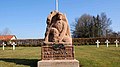 Statue carved February 15, 1916
 -
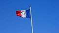 French flag in the military cemetery
 -
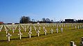 Crosses in the military cemetery
 -
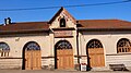 Covered market


Personalities edit
It is the birth town of the astronomer Charles Messier (1730–1817).
See also edit
References edit
- ^ "Répertoire national des élus: les maires". data.gouv.fr, Plateforme ouverte des données publiques françaises (in French). 2 December 2020.
- ^ "Populations légales 2021". The National Institute of Statistics and Economic Studies. 28 December 2023.
- ^ "Fiche Climatologique Statistiques 1991-2020 et records" (PDF). Météo-France. Retrieved 23 August 2022.
- ^ Population en historique depuis 1968, INSEE
Wikimedia Commons has media related to Badonviller.