


Summary
Baharestan County (Persian: شهرستان بهارستان) is in Tehran province, Iran. Its capitals are the cities of Golestan and Nasimshahr.[3]
Baharestan County
Persian: شهرستان بهارستان | |
|---|---|
County | |
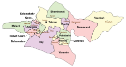 Location of Baharestan County in Tehran province (center left, yellow) | |
 Location of Tehran province in Iran | |
| Coordinates: 35°32′N 51°12′E / 35.533°N 51.200°E[1] | |
| Country | |
| Province | Tehran |
| Capitals | Golestan and Nasimshahr |
| Districts | Bostan, Golestan |
| Population (2016)[2] | |
| • Total | 536,329 |
| Time zone | UTC+3:30 (IRST) |
After the 2006 National Census, Bostan District and Golestan District (except the city of Nasirshahr) were separated from Robat Karim County in the establishment of Baharestan County, which was divided into two districts of two rural districts each, with the cities of Golestan and Nasimshahr as its capitals.[3]
The census in 2011 counted 523,636 people in 143,512 households.[4] At the 2016 census, the county's population was 536,329 in 156,791 households.[2]
According to the information of the State Meteorological Organization of Iran, the long-term average annual rainfall of baharestan is around 176.2 mm[5]
Administrative divisions edit
The population history and structural changes of Baharestan County's administrative divisions over two consecutive censuses are shown in the following table. The latest census shows two districts, four rural districts, and three cities.[2]
| Administrative Divisions | 2011[4] | 2016[2] |
|---|---|---|
| Bostan District | 198,542 | 229,603 |
| Esmailabad RD | 1 | 0 |
| Hamedanak RD | 41,063 | 29,210 |
| Nasimshahr (city) | 157,474 | 200,393 |
| Golestan District | 325,077 | 306,726 |
| Meymanat RD | 8,258 | 7,353 |
| Salehabad RD | 983 | 1,134 |
| Golestan (city) | 259,480 | 239,556 |
| Salehieh (city) | 56,356 | 58,683 |
| Total | 523,636 | 536,329 |
| RD: Rural District 1Population was below the reporting threshold | ||
References edit
- ^ OpenStreetMap contributors (5 April 2023). "Baharestan County" (Map). OpenStreetMap. Retrieved 5 April 2023.
- ^ a b c d "Census of the Islamic Republic of Iran, 1395 (2016)". AMAR (in Persian). The Statistical Center of Iran. p. 23. Archived from the original (Excel) on 12 December 2021. Retrieved 19 December 2022.
- ^ a b Rahimi, Mohammad Reza (21 December 2013). "Approval letter regarding country divisions in Tehran province". Islamic Parliament Research Center (in Persian). Ministry of Interior, Council of Ministers. Archived from the original on 5 March 2016. Retrieved 23 October 2023.
- ^ a b "Census of the Islamic Republic of Iran, 1390 (2011)". Syracuse University (in Persian). The Statistical Center of Iran. p. 23. Archived from the original (Excel) on 20 January 2023. Retrieved 19 December 2022.
- ^ https://tehranmet.ir/uploads/tahghighat/140201.pdf