
KNOWPIA
WELCOME TO KNOWPIA

Bakay-Ata District 
Summary
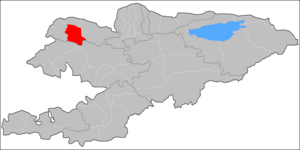
Bakay-Ata (Kyrgyz: Бакай-Ата району) is a district of Talas Region in north-western Kyrgyzstan. Its area is 2,928 square kilometres (1,131 sq mi),[1] and its resident population was 53,359 in 2021.[2] The administrative seat lies at Bakay-Ata (the former Leninpol).[3]
Bakay-Ata
Бакай-Ата району | |
|---|---|
 | |
| Country | Kyrgyzstan |
| Region | Talas |
| Area | |
| • Total | 2,928 km2 (1,131 sq mi) |
| Population (2021) | |
| • Total | 53,359 |
| • Density | 18/km2 (47/sq mi) |
| Time zone | UTC+6 |
Population edit
| Year | Pop. | ±% p.a. |
|---|---|---|
| 1970 | 26,701 | — |
| 1979 | 33,290 | +2.48% |
| 1989 | 39,676 | +1.77% |
| 1999 | 38,898 | −0.20% |
| 2009 | 44,057 | +1.25% |
| 2021 | 53,359 | +1.61% |
| Note: resident population; Sources:[1][2] | ||
Rural communities and villages edit
In total, Bakay-Ata District includes 19 settlements located in 9 rural communities (ayyl aymagy). Each rural community can consist of one or several villages. The rural communities and settlements in the Bakay-Ata District are:[3][4]
- Ak-Döbö (seat: Ak-Döbö; incl. Kyzyl-Say and Kyzyl-Charba)
- Aknazarov (seat: Kyzyl-Oktyabr; incl. Kök-Tash, Madaniyat, Tash-Kuduk and Ür-Maral)
- Bakay-Ata (2: center - village: Bakay-Ata; and also village Namatbek)
- Boo-Terek (seat: Boo-Terek)
- Keng-Aral (seat: Keng-Aral)
- Ming-Bulak (seat: Ming-Bulak)
- Oros (seat: Kyrgyzstan; incl. Jon-Korgon and Birinchi May)
- Özgörüsh (seat: Özgörüsh)
- Shadykan (seat: Yntymak; incl. Tüytö)

Tüytö
Kyzyl-Oktyabr
Kök-Tash
Madaniyat
Tash-Kuduk
Ür-Maral
Keng-Aral
Namatbek
Ming-Bulak
Kyzyl-Say
Kyzyl-Charba
Kyrgyzstan
Jon-Korgon
Birinchi May
class=notpageimage|
Settlements of the Bakay-Ata District.
Notable people
edit
- Gulsaira Momunova - poet (1937 - 2020).
References edit
- ^ a b "2009 population and housing census of the Kyrgyz Republic: Talas Region" (PDF) (in Russian). National Statistics Committee of the Kyrgyz Republic. 2010. pp. 12, 15.
- ^ a b "Population of regions, districts, towns, urban-type settlements, rural communities and villages of Kyrgyz Republic" (XLS) (in Russian). National Statistics Committee of the Kyrgyz Republic. 2021. Archived from the original on 10 November 2021.
- ^ a b "Classification system of territorial units of the Kyrgyz Republic" (in Kyrgyz). National Statistics Committee of the Kyrgyz Republic. May 2021. pp. 64–65.
- ^ List of rural communities of Kyrgyzstan Archived 2010-02-09 at the Wayback Machine
42°28′48″N 71°54′36″E / 42.48000°N 71.91000°E