


Summary
The Bakoy or Bakoye River (French: Rivière Bakoy) is a river in West Africa. It runs through Guinea and Mali and joins with the Bafing River to form the Sénégal River at Bafoulabé in the Kayes Region of western Mali. In Manding languages, Bakoye signifies 'white river', Bafing 'black river' and Baloué 'red river'.[2][3]
| Bakoy River | |
|---|---|
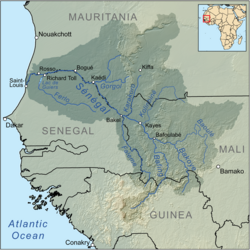 Map of the Sénégal River drainage basin | |
| Native name | Rivière Bakoye (French) |
| Location | |
| Countries | Guinea and Mali |
| Physical characteristics | |
| Source | Monts Ménien |
| • location | Menien-Koma, Guinea |
| • coordinates | 11°50′N 9°45′W / 11.833°N 9.750°W |
| • elevation | 760 m (2,490 ft) |
| Mouth | Sénégal River |
• location | Bafoulabé, Mali |
• coordinates | 13°48′50″N 10°49′41″W / 13.81389°N 10.82806°W |
• elevation | 83 m (272 ft) |
| Length | 560 km (350 mi) |
| Basin size | 85,600 km2 (33,100 sq mi) |
| Discharge | |
| • average | 156 m3/s (5,500 cu ft/s) |
| Basin features | |
| River system | Sénégal River |
| Tributaries | |
| • right | Baloué 13°32′58″N 9°54′35″W / 13.54944°N 9.90972°W |

The source of the Bakoy is at an elevation of 760 m in the granite Monts Ménien to the northwest of Siguiri in Guinea. The river flows north and forms part of the international border between Guinea and Mali. It then meanders across the Manding Plateau and joins its principal affluent, the Baloué, which rises to the west of Bamako.[4] The Bakoy is 560 km in length[5] and drains a basin of around 85,600 km2. The river is seasonal with a maximum flow in September after the start of the West African Monsoon and almost no flow between January and June.[1] The large year-to-year variation in the intensity of the West African Monsoon gives rise to large changes in the discharge of the Bakoy River. For the exceptionally dry year of 1972, the average flow at the Oualia gauging station, 54 km upstream of Bafoulabé, was only 30 m3/s while in 1958 the value was 260 m3/s. The average flow over the period 1951-1978 was 156 m3/s corresponding to an annual discharge of 4.9 km3.[1] At Bafoulabé the average discharge of the Bakoy is between a third and a half of that of the Bafing.[6]
References edit
- ^ a b c Hydrographic data for Oualia, Mali 1951-1978, Unesco International Hydrological Programme, archived from the original on 2009-12-03, retrieved 2 Jun 2012.
- ^ Caractéristiques physiques du fleuve Sénégal (in French), Organisation pour la mise en valeur du fleuve Sénégal, archived from the original on 2013-07-16, retrieved 2 June 2012.
- ^ Maïga, Mahamadou (1995), Le bassin du fleuve Sénégal: de la Traite négrière au développement sous-régional autocentré (in French), L'Harmattan, p. 14 footnotes 4, 5.
- ^ SENEGAL-HYCOS: Renforcement des capacités nationales et régionales d’observation, transmission et traitement de données pour contribuer au développement durable du bassin du Fleuve Sénégal (Document de projet préliminaire) (PDF) (in French), Système Mondial d’Observation du Cycle Hydrologique (WHYCOS), 2007, p. 4, archived from the original (PDF) on 2013-12-28.
- ^ Shahin, Mamdouh (2002), Hydrology and Water Resources of Africa, New York: Kluwer, p. 379, ISBN 9781402008665.
- ^ Étude des impacts environnementaux du projet d’aménagement de Félou (PDF) (in French), Organisation pour la mise en valeur du fleuve Sénégal, 2006, pp. 59–61.