
KNOWPIA
WELCOME TO KNOWPIA

Bala, Kansas 
Summary
Bala is an unincorporated community in Bala Township, Riley County, Kansas, United States.[1] As of the 2020 census, the population of the community and nearby areas was 29.[2]
Bala, Kansas | |
|---|---|
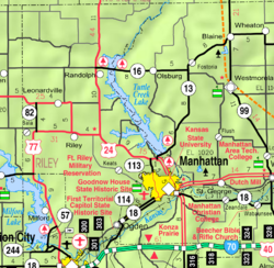 KDOT map of Riley County (legend) | |
 Bala  Bala | |
| Coordinates: 39°18′39″N 96°57′01″W / 39.31083°N 96.95028°W[1] | |
| Country | United States |
| State | Kansas |
| Counties | Riley |
| Founded | 1862 |
| Named for | Bala |
| Elevation | 1,293 ft (394 m) |
| Population | |
| • Total | 29 |
| Time zone | UTC-6 (CST) |
| • Summer (DST) | UTC-5 (CDT) |
| Area code | 785 |
| FIPS code | 20-03800 |
| GNIS ID | 2804655[1] |
History edit
Bala settled about 1862. It was a shipping point on the Chicago, Rock Island and Pacific Railroad.[3] It is named after Bala, in Wales.[4]
A post office was opened in Bala in 1871, and remained in operation until it was discontinued in 1966.[5]
Demographics edit
| Census | Pop. | Note | %± |
|---|---|---|---|
| 2020 | 29 | — | |
| U.S. Decennial Census | |||
For statistical purposes, the United States Census Bureau has defined Bala as a census-designated place (CDP).
Education edit
The community is served by Riley County USD 378 public school district.
References edit
- ^ a b c d U.S. Geological Survey Geographic Names Information System: Bala, Kansas
- ^ a b "Profile of Bala, Kansas (CDP) in 2020". United States Census Bureau. Archived from the original on April 26, 2022. Retrieved April 26, 2022.
- ^ Blackmar, Frank Wilson (1912). Kansas: A Cyclopedia of State History, Embracing Events, Institutions, Industries, Counties, Cities, Towns, Prominent Persons, Etc. Standard Publishing Company. pp. 132.
- ^ "Profile for Bala, Kansas". ePodunk. Retrieved June 22, 2014.
- ^ "Kansas Post Offices, 1828-1961". Kansas Historical Society. Archived from the original on October 9, 2013. Retrieved June 22, 2014.
Further reading edit
External links edit
- Riley County maps: Current, Historic, KDOT