


Summary
Balabac, officially the Municipality of Balabac (Tagalog: Bayan ng Balabac), is a 2nd class municipality in the province of Palawan, Philippines. According to the 2020 census, it has a population of 42,527 people.[3]
Balabac
Tagbariri | |
|---|---|
| Municipality of Balabac | |
 Benlen Sandbar | |
 Flag  Seal | |
 Map of Palawan with Balabac highlighted | |
OpenStreetMap  | |
 Balabac Location within the Philippines | |
| Coordinates: 7°59′N 117°03′E / 7.98°N 117.05°E | |
| Country | Philippines |
| Region | Mimaropa |
| Province | Palawan |
| District | 2nd district |
| Founded | 1957 |
| Barangays | 20 (see Barangays) |
| Government | |
| • Type | Sangguniang Bayan |
| • Mayor | Shuaib J. Astami |
| • Vice Mayor | Al-Hazni A. Astami |
| • Representative | Jose Alvarez |
| • Municipal Council | Members |
| • Electorate | 24,092 voters (2022) |
| Area | |
| • Total | 581.60 km2 (224.56 sq mi) |
| Elevation | 4.0 m (13.1 ft) |
| Highest elevation | 1,035 m (3,396 ft) |
| Lowest elevation | 0 m (0 ft) |
| Population (2020 census)[3] | |
| • Total | 42,527 |
| • Density | 73/km2 (190/sq mi) |
| • Households | 9,267 |
| Economy | |
| • Income class | 2nd municipal income class |
| • Poverty incidence | 29.74 |
| • Revenue | ₱ |
| • Assets | ₱ |
| • Expenditure | ₱ |
| • Liabilities | ₱ |
| Service provider | |
| • Electricity | Palawan Electric Cooperative (PALECO) |
| Time zone | UTC+8 (PST) |
| ZIP code | 5307 |
| PSGC | 1705304000 |
| IDD : area code | +63 (0)48 |
| Native languages | Molbog Kagayanen Palawano Tagalog |
History edit
Balabac was converted from a municipal district to a full municipality in 1957. Before that, it was a barrio of neighboring Bataraza.[5]
Cape Melville Lighthouse edit
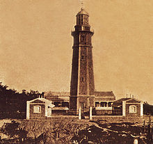
The Cape Melville Lighthouse, located on the island of Balabac, is one of the Philippines oldest lighthouses built in 1892[6] during the Spanish era and a major landmark of the town.
Geography edit
Not considering the disputed Spratly Islands, the municipality is the westernmost point in the Philippines. It is separated from Sabah by the Balabac Strait.
The municipality consists of some 36 islands,[7] including the eponymous Balabac Island. The islands are notable for their uncommon indigenous plant and animal species, such as the nocturnal Philippine mouse-deer (or Pilandok). The islands are also home to dugongs, saltwater crocodiles, sawfishes, and sea turtles. Due to its biodiversity, the terrestrial and marine ecosystems of the Balabac archipelago are currently being pushed by scholars to be included in the tentative list of the Philippines for a possible UNESCO World Heritage Site nomination in the future.
Islands edit
The municipality of Balabac is composed of a group of 36 major and minor islands, notable of which are the following:
|
|
Shoals and sandbars edit
The municipality of Balabac is composed of various islands located at the Balabac Strait. The strait is known for its shallow waters due to the presence of shoals and numerous sandbars. Balabac has the third and fourth longest sandbars in the Philippines. The third longest is Queen Helen Sandbar at the southern tip of Bugsuk and the fourth is the Angela Sandbar east of Mansalangan.[8]
Barangays edit
Balabac is politically subdivided into 20 barangays: Each barangay consists of puroks and some have sitios.
Climate edit
Balabac has a tropical monsoon climate (Am) with moderate rainfall from February to May and heavy rainfall in the remaining months.
| Climate data for Balabac | |||||||||||||
|---|---|---|---|---|---|---|---|---|---|---|---|---|---|
| Month | Jan | Feb | Mar | Apr | May | Jun | Jul | Aug | Sep | Oct | Nov | Dec | Year |
| Mean daily maximum °C (°F) | 28.9 (84.0) |
29.3 (84.7) |
29.8 (85.6) |
30.6 (87.1) |
30.9 (87.6) |
30.5 (86.9) |
30.1 (86.2) |
30.3 (86.5) |
29.2 (84.6) |
29.7 (85.5) |
29.5 (85.1) |
29.1 (84.4) |
29.8 (85.7) |
| Daily mean °C (°F) | 25.3 (77.5) |
25.5 (77.9) |
25.9 (78.6) |
26.5 (79.7) |
26.9 (80.4) |
26.6 (79.9) |
26.2 (79.2) |
26.3 (79.3) |
25.2 (77.4) |
26.0 (78.8) |
25.8 (78.4) |
25.6 (78.1) |
26.0 (78.8) |
| Mean daily minimum °C (°F) | 21.7 (71.1) |
21.7 (71.1) |
22.0 (71.6) |
22.5 (72.5) |
23.0 (73.4) |
22.7 (72.9) |
22.3 (72.1) |
22.3 (72.1) |
21.3 (70.3) |
22.3 (72.1) |
22.2 (72.0) |
22.1 (71.8) |
22.2 (71.9) |
| Average rainfall mm (inches) | 181 (7.1) |
71 (2.8) |
80 (3.1) |
59 (2.3) |
121 (4.8) |
145 (5.7) |
140 (5.5) |
146 (5.7) |
155 (6.1) |
184 (7.2) |
260 (10.2) |
324 (12.8) |
1,866 (73.3) |
| Source: Climate-Data.org[9] | |||||||||||||
Demographics edit
|
| ||||||||||||||||||||||||||||||||||||||||||||||||
| Source: Philippine Statistics Authority[10][11][12][13] | |||||||||||||||||||||||||||||||||||||||||||||||||
In the 2020 census, the population of Balabac was 42,527 people,[3] with a density of 73 inhabitants per square kilometre or 190 inhabitants per square mile.
Economy edit
Culture edit
The Molbog people dominate the municipality of Balabac, as well as the municipality of Bataraza in the north. The area is the homeland of the Molbog people since the classical era prior to Spanish colonization. The Molbog are known to have a strong connection with the natural world, especially with the sacred pilandok (Philippine mouse-deer), which can only be found in the Balabac islands. An indigenous folktale tells the story of a naughty Philippine mouse-deer that tricked a prince into giving up his bag of gold while facing a hive of angry bees.[21] Another tale depicts him as a clever guardian of the environment, using his wisdom as an advantage against those who destroy forests, seas, and wildlife.[22] The coconut is especially important in Molbog culture as it is their most prized agricultural crop.[23]
Transportation edit
Balabac is a three-hour boat trip from Bataraza on the island of Palawan; Bataraza in turn can be reached from Palawan's capital city Puerto Princesa.
An old airstrip located on the island of Bugsuk serves no commercial flights. Another private airstrip is located on the island of Ramos.
Healthcare edit
- Balabac District Hospital is situated in Barangay Catagupan
References edit
- ^ Municipality of Balabac | (DILG)
- ^ "2015 Census of Population, Report No. 3 – Population, Land Area, and Population Density" (PDF). Philippine Statistics Authority. Quezon City, Philippines. August 2016. ISSN 0117-1453. Archived (PDF) from the original on May 25, 2021. Retrieved July 16, 2021.
- ^ a b c Census of Population (2020). "Mimaropa". Total Population by Province, City, Municipality and Barangay. Philippine Statistics Authority. Retrieved 8 July 2021.
- ^ "PSA Releases the 2018 Municipal and City Level Poverty Estimates". Philippine Statistics Authority. 15 December 2021. Retrieved 22 January 2022.
- ^ "R.A. No. 2022, An Act Converting the Municipal District of Balabac, Province of Palawan, into a Regular Municipality". LawPH.com. Archived from the original on 2012-07-10. Retrieved 2011-04-13.
- ^ "ANC". ABS-CBN News.
- ^ "At the tip of the last frontier | Manila Bulletin | Latest Breaking News | News Philippines". Manila Bulletin. Archived from the original on 2015-04-17.
- ^ Malicdem, Ervin (12 July 2017). "10 Longest Sandbars of the Philippines". Schadow1 Expeditions. Retrieved 29 October 2017.
- ^ "Climate: Balabac". Climate-Data.org. Retrieved 25 October 2020.
- ^ Census of Population (2015). "Region IV-B (Mimaropa)". Total Population by Province, City, Municipality and Barangay. Philippine Statistics Authority. Retrieved 20 June 2016.
- ^ Census of Population and Housing (2010). "Region IV-B (Mimaropa)" (PDF). Total Population by Province, City, Municipality and Barangay. National Statistics Office. Retrieved 29 June 2016.
- ^ Censuses of Population (1903–2007). "Region IV-B (Mimaropa)". Table 1. Population Enumerated in Various Censuses by Province/Highly Urbanized City: 1903 to 2007. National Statistics Office.
{{cite encyclopedia}}: CS1 maint: numeric names: authors list (link) - ^ "Province of". Municipality Population Data. Local Water Utilities Administration Research Division. Retrieved 17 December 2016.
- ^ "Poverty incidence (PI):". Philippine Statistics Authority. Retrieved December 28, 2020.
- ^ "Estimation of Local Poverty in the Philippines" (PDF). Philippine Statistics Authority. 29 November 2005.
- ^ "2003 City and Municipal Level Poverty Estimates" (PDF). Philippine Statistics Authority. 23 March 2009.
- ^ "City and Municipal Level Poverty Estimates; 2006 and 2009" (PDF). Philippine Statistics Authority. 3 August 2012.
- ^ "2012 Municipal and City Level Poverty Estimates" (PDF). Philippine Statistics Authority. 31 May 2016.
- ^ "Municipal and City Level Small Area Poverty Estimates; 2009, 2012 and 2015". Philippine Statistics Authority. 10 July 2019.
- ^ "PSA Releases the 2018 Municipal and City Level Poverty Estimates". Philippine Statistics Authority. 15 December 2021. Retrieved 22 January 2022.
- ^ "Tales of Laughter - Pilandok and the Sumusong-sa-Alongan". folklore.philsites.net. Archived from the original on 2011-07-26. Retrieved 2019-02-09.
- ^ "Pilandok Series by Virgilio S. Almario". www.goodreads.com.
- ^ "National Commission for Culture and the Arts - A Filipino people with a strong sense of nationhood and deep respect for cultural diversity". National Commission for Culture and the Arts. Retrieved 2021-07-14.
External links edit
- Balabac Profile at PhilAtlas.com
- Philippine Standard Geographic Code
- Philippine Census Information
- Local Governance Performance Management System