


Summary
The Banat Military Frontier or simply Banat Frontier (Serbian: Банатска крајина/Banatska krajina; Romanian: Granița militară Bănățeană; German: Banater Militärgrenze) was a district of the Habsburg monarchy's Military Frontier during the 18th and 19th centuries. It was located in southern parts of the Banat region. It was formed in 1764, out of territories of the Banat of Temeswar. Today, the territory is split between Serbia and Romania.[1][2]
| Banat Military Frontier | |||||||
|---|---|---|---|---|---|---|---|
| District of the Military Frontier, Habsburg monarchy | |||||||
| 1751–1873 | |||||||
 1849–60 political map | |||||||
| History | |||||||
• Established | 1751 | ||||||
• Disestablished | 1873 | ||||||
| |||||||
| Today part of | Hungary Serbia Romania | ||||||
Geography edit
The Frontier was divided into Serb (Illyrian), German (Danube Swabian) and Romanian (Vlach) sections. It included parts of modern-day Banat and the south-eastern part of Bačka region, known as Šajkaška. Some of the important cities and places were: Pančevo, Bela Crkva, Titel, Žabalj, Alibunar, Kovin, and Caransebeş.
History edit
The military province of Habsburg monarchy known as the Banat of Temeswar was created in 1718. In 1751, Maria Theresa introduced a civil administration for the northern part of the province. The southern part remained under military administration and was organized as the Banat Military Frontier. In 1849, this part of the Military Frontier bordered the Principality of Serbia to the south, Voivodeship of Serbia and Banat of Temeschwar to the north, Transylvania and Wallachia to the east, and the Slavonian Military Frontier to the west. It remained a part of the Habsburg Military Frontier until it was abolished in 1871.
-
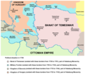 Map of Military Frontier sections in Syrmia, Bačka, and Pomorišje in 1718–44
 -
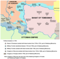 Map of Military Frontier sections in Syrmia, Bačka, and Pomorišje in 1744–50
 -
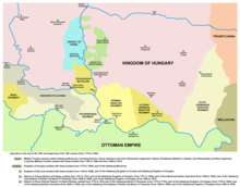
 Map of Military Frontier sections in Syrmia, Bačka, and Banat in 1751–1778


Administration edit
| Division | Seat | Notes |
|---|---|---|
| German | Pančevo | |
| Romanian (Vlach) | Caransebeș | |
| Serbian (Illyrian) | Bela Crkva |
Demographics edit
1857 edit
Total of 386,255 people:[3]
- 314,514 (81.43%) Eastern Orthodox
- 51,860 (13.43%) Roman Catholics
- 19,418 (5.03%) Evangelists
- 393 (0.1%) Jews
- 70 (0.01%) others
See also edit
References edit
- ^ Ilić-Mandić 2020, p. 99-121.
- ^ Ilić-Mandić 2022a, p. 207-228.
- ^ Bundesministerium für Inneres (1859). Statistische Übersichten Über Die Bevölkerung und Den Viehstand Von Österreich. Nach Der Zählung Vom 31. October 1857. p. 176.
Sources edit
- Dabić, Vojin S. (2011). "The Habsburg-Ottoman War of 1716-1718 and Demographic Changes in the War-Afflicted Territories". The Peace of Passarowitz, 1718. West Lafayette: Purdue University Press. pp. 191–208.
- Ilić-Mandić, Jelena (2020). "The Local Elite in Central Government Service: Banat Military Frontier Officers in the 18th Century". The Habsburg State-wide and the regions in the Southern Danube basin (16th-20th centuries). Wien: New academic press. pp. 99–121.
- Ilić-Mandić, Jelena (2021). "Forging the Wallachian Military Border, 1769-1772" (PDF). Banatica. 31 (2): 251–273.
- Ilić-Mandić, Jelena (2022a). "Making the Border and Frontiersmen: Militarisation in Temeswarer Banat, 1764-1775". From medieval frontiers to early modern borders in Central and South-Eastern Europe. Berlin: Peter Lang Publishing. pp. 207–228.
- Ilić-Mandić, Jelena (2022b). "The Military Frontier and Emigration Challenges in the 18th Century" (PDF). Migrations in the Slavic Cultural Space From the Middle Ages to the Present Day. Lódź: Wydawnictwo Universytetu Lódzkiego. pp. 45–62.
- Kılıç, Orhan (1997). 18. Yüzyılın İlk Yarısında Osmanlı Devleti'nin İdari Taksimatı: Eyalet ve Sancak Tevcihatı. Elazığ: Şark Pazarlama.
External links edit
- Map
- Map
- Map