


Summary
The Bandung Metropolitan Area, officially called the Bandung Basin (Cekungan Bandung)[4] or Greater Bandung (Bandung Raya), is a metropolitan area surrounding the city of Bandung, West Java, Indonesia.[5] It was home to over nine million people in mid 2023 and is composed of regencies and cities previously part of the Dutch East Indies era "Central Priangan Residency" administration.
Bandung Basin
Cekungan Bandung | |
|---|---|
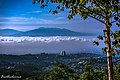
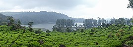
From top, left to right: Bandung Basin viewed from Mount Batu, Bandung skyline, view of Central Bandung from the north, Pasupati Bridge in Bandung, Malela Falls in West Bandung Regency Patenggang Lake in Bandung Regency. | |
 Bandung Basin in West Java shown in verdigris | |
| Coordinates: 6°55′26″S 107°36′23″E / 6.92389°S 107.60639°E | |
| Country | |
| Province | |
| Core city | Bandung |
| Satellite city | Cimahi |
| Regencies | Bandung Regency West Bandung Regency part of Sumedang Regency |
| Area | |
| • Metro | 3,484.08 km2 (1,345.21 sq mi) |
| Population (mid 2023 estimate)[1] | |
| • Urban | 2,506,603 |
| • Metro | 9,054,175 |
| • Metro density | 2,600/km2 (6,700/sq mi) |
| Time zone | UTC+7 (Indonesia Western Time) |
| Postcodes | 40xxx |
| Area codes | (62)22 |
| Vehicle sign | D |
| GDP (nominal) | 2022[2][3] |
| - Total | |
| - Per capita | |
| Website | metropolitan |
| Highest elevation 2,608 m/8,556 ft (Mount Kendang, in Bandung Regency) | |


Due to ongoing development in urban areas between Bandung, Kertajati International Airport, Aerotropolis and Patimban International Seaport,[6] the West Java provincial government and the Regional Planning Board (BAPPEDA) has prepared and publicized a blueprint for a newly defined (extended) Bandung Metropolitan area with a total area more than 5,500 km2 and a population greater than 11 million people.
Location edit
Bandung is located in a mountainous plateau region in the central portion of West Java province and has the third highest population of any metropolitan area in Indonesia.
Western Java urban corridor edit
The Bandung metropolitan area begins less than 20 km from the eastern edge of the metropolitan area of Greater Jakarta ("Jabodetabek") near Cianjur city, and is adjacent (contiguous) with the Jabodetabekjur-Cirangkarta definition for Jakarta's extended metropolitan area (250 km or so long) at its northern border with Purwakarta Regency. Stretching from Serang Regency in Banten Province to include Greater Bandung, this relatively narrow urban corridor hemmed in by volcanoes is home to estimated 50 million people as of 2020, or a third of the islands population and a bit less than a fifth of the entire nation.
Definition edit
The Bandung Metropolitan area was officially defined as covering Bandung Regency and West Bandung Regency (which until 2007 was part of Bandung Regency), plus part (5 districts[7]) of Sumedang Regency, together with the cities of Bandung and Cimahi.[5]
| Administrative division | Area in km2[8] |
Population 2010 Census[9] |
Population 2020 Census[10] |
Population mid 2023 Estimate[1] |
Population density (per km2 mid 2023) |
|---|---|---|---|---|---|
| Bandung City | 167.31 | 2,394,873 | 2,444,160 | 2,506,603 | 14,982 |
| Cimahi City | 42.43 | 541,177 | 568,400 | 590,782 | 13,924 |
| Bandung Regency | 1,762.40 | 3,178,543 | 3,623,790 | 3,721,111 | 2,111 |
| West Bandung Regency | 1,287.41 | 1,506,448 | 1,788,336 | 1,859,636 | 1,444 |
| Sumedang Regency (part) | 224.53 | 349,750 | 365,622 | 376,043 | 1,675 |
| Metropolitan area | 3,484.08 | 7,970,791 | 8,790,308 | 9,054,175 | 2,599 |
As subsequently extended, the new metropolitan region includes the entire Sumedang Regency with parts of Subang Regency and Majalengka Regency; and it borders the Cirebon metropolitan area. Together, the two metro areas comprise over 14 million people[11] Sources: (Budan Pusat Statistik 2023 and earlier, Indonesia)
- https://web.archive.org/web/20101113175446/http://www.bps.go.id/hasilSP2010/jabar/3211.pdf (for kecamatan)
- https://web.archive.org/web/20120628013636/http://www.bps.go.id/aboutus.php?sp=0&kota=32 Tabel Hasil Sensus Penduduk 2010 Provinsi JAWA BARAT (for all others)
- https://web.archive.org/web/20131014170450/http://www.jabarprov.go.id/index.php/subMenu/75 Sumber : Database SIAK Provinsi Jawa Barat Tahun 2011
- (BPS Jabar 2015) Satudata Jawa Barat BPS Jumlah Penduduk Kabupaten/ Kota di Jawa Barat Tahun 2010 - 2015
- Note that area figures in Indonesia are frequently updated as the country is seismically and volcanically very active, and land subsidence due to changes in land use and population pressures. 3 kecamatan data were not updated, assuming no changes to older data from 2010 data.
See also edit
References edit
- ^ a b Badan Pusat Statistik, Jakarta, 2024.
- ^ Badan Pusat Statistik Jawa Barat (2022). Produk Domestik Regional Bruto Kabupaten/kota di Jawa Barat 2019-2021. Bandung: Badan Pusat Statistik.
- ^ "PDRB Atas Dasar Harga Berlaku Menurut Pengeluaran Kabupaten/Kota (Juta Rupiah) [SERI 2010], 2021-2022". www.bps.go.id.
- ^ "SIFATARU - Cekungan Bandung".
- ^ a b "Archived copy" (PDF). Archived from the original (PDF) on 2013-01-23. Retrieved 2012-03-19.
{{cite web}}: CS1 maint: archived copy as title (link) - ^ Yoesoef Adji (April 26, 2016). "Pelabuhan Patimban Siap Gantikan Cilamaya".
- ^ The five districts (kecamatan) in the southwest corner of Sumedang Regency are Jatinangor, Cimanggung, Tanjungsari, Sukasari and Pamulihan.
- ^ "Portal Nasional RI - Target Kunjungan Wisman 2009 Diyakini Tercapai". Archived from the original on 2013-12-30. Retrieved 2016-02-08. Indonesia.go.id: for area and http://www.jabarprov.go.id/jabar/public/85701/menu.htm?id=85701 Archived 2008-05-30 at the Wayback Machine Javabarat.go.id for population
- ^ Publikasi Provinsi dan Kabupaten Hasil Sementara SP2010 Archived 2010-10-13 at the Wayback Machine
- ^ Badan Pusat Statistik, Jakarta, 2021.
- ^ "Jabar Kembangkan Tiga Kawasan Metropolitan". 6 April 2015.