


Summary
Barnet was a local government district in south Hertfordshire from 1863 to 1965 around the town of Barnet.
| Barnet | |
|---|---|
| Local Government District (1863–1894) Urban District (1894–1965) | |
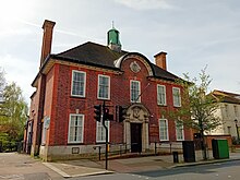 Council's offices, now the North London Coroner's Court | |
| Area | |
| • 1911 | 1,510 acres (6.1 km2)[1] |
| • 1931 | 3,114 acres (12.6 km2)[1] |
| • 1961 | 4,290 acres (17.4 km2)[1] |
| Population | |
| • 1911 | 10,440[1] |
| • 1931 | 14,726[1] |
| • 1961 | 27,846[1] |
| Density | |
| • 1911 | 6.9/acre |
| • 1931 | 4.7/acre |
| • 1961 | 6.5/acre |
| History | |
| • Created | 5 October 1863 |
| • Abolished | 31 March 1965 |
| • Succeeded by | London Borough of Barnet |
| Government | Barnet Local Board (1863-1894) Barnet Urban District Council (1894-1965) |
| • HQ | 29 Wood Street, Barnet |
Creation edit
Barnet Local Government District was created on 5 October 1863, after the town's ratepayers decided to adopt the Local Government Act 1858, and it was governed by a local board.[2] Under the Public Health Act 1872 local government districts were also designated as urban sanitary districts. The Local Government Act 1894 (56 & 57 Vict. c. 73) reconstituted the area as an urban district with effect from 31 December 1894, and the local board was replaced by an elected Barnet Urban District Council.[3] The urban district was extended in 1905, 1914 and 1935.[4]
Civil parishes edit
The district originally consisted of parts of the parishes of Chipping Barnet in Hertfordshire, and Monken Hadley and South Mimms in Middlesex. The Local Government Act 1888 adjusted the county boundaries in 1889, so that the entire district was in Hertfordshire; forming part of a long, thin protrusion into Middlesex surrounded by that county on two sides, to the north and south.
The Local Government Act 1894 (56 & 57 Vict. c. 73) divided the urban district into three civil parishes:
- Chipping Barnet (from the part of Chipping Barnet parish in Barnet Urban District)
- Hadley (from the part of Monken Hadley parish in Barnet Urban District)
- South Mimms Urban (from the part of South Mimms parish in Barnet Urban District)
On 30 September 1896 the parish of South Mimms Urban (and therefore Barnet Urban District) was enlarged, gaining area previously in the parish of South Mimms (South Mimms Rural District).[5] On 25 June the following year the parish of Chipping Barnet was also enlarged, gaining area previously in the parish of Arkley (Barnet Rural District).[6]
In 1905 and 1914 respectively the parishes of Arkley and Totteridge were added, from Barnet Rural District. Rowley parish was added on 1 April 1935, created from area of the parishes of Elstree, Ridge and Shenley that lay east of the A1 in the Barnet Rural District.[4]
Abolition edit
Barnet Urban District was abolished by the London Government Act 1963 and its former area transferred from Hertfordshire to Greater London on 1 April 1965. Its former area was combined with that of other districts to form the present-day London Borough of Barnet.
Politics edit
The urban district was divided into six wards for elections: Arkley East, Arkley West, Barnet North, Barnet South, Totteridge East and Totteridge West.
Urban district council edit
Parliament constituency edit
For elections to Parliament, the urban district was part of the constituency of:
In 1945 St Albans was divided as an emergency measure because its electorate exceeded 100,000 voters, with the urban district becoming part of the new constituency of:
Gallery edit
-
 In 1961: 1 is Barnet and 2 is East Barnet
 -
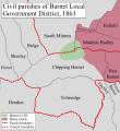 District in 1863.
 -
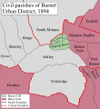 District in 1894.
 -
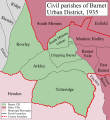 District in 1935.


References edit
- ^ a b c d e f Great Britain Historical GIS / University of Portsmouth, Barnet UD population (area and density). Retrieved 2008-01-28.
- ^ "No. 22776". The London Gazette. 2 October 1863. p. 4745.
- ^ Kelly's Directory of Hertfordshire 1899, p.31 (Historical Directories), accessed January 27, 2008
- ^ a b Frederic A Youngs Jr., Guide to the Local Administrative Units of England, Vol I: Southern England, London ,1979
- ^ "South Mimms Urban CP Boundary changes". A Vision of Britain. Retrieved 31 May 2014.
- ^ "Chipping Barnet Ch/CP Boundary changes". A Vision of Britain. Retrieved 31 May 2014.
External links edit
Great Britain Historical GIS / University of Portsmouth, Barnet UD (historic map). Retrieved 28 January 2008.
- Barnet Society web site
51°39′N 0°12′W / 51.650°N 0.200°W