


Summary
Barton Turf is a village and civil parish in the English county of Norfolk. It is 20 km north-east of the city of Norwich, on the northwestern edge of Barton Broad, the second largest of the Norfolk Broads.[1] In primary local government the area is in the district of North Norfolk.[2]
| Barton Turf | |
|---|---|
 St Michael and All Angels' parish church | |
 Barton Turf Location within Norfolk | |
| Area | 10.86 km2 (4.19 sq mi) |
| Population | 467 (2011) |
| • Density | 44/km2 |
| OS grid reference | TG353224 |
| • London | 132 miles (212 km) |
| Civil parish |
|
| District | |
| Shire county | |
| Region | |
| Country | England |
| Sovereign state | United Kingdom |
| Post town | NORWICH |
| Postcode district | NR12 |
| Dialling code | 01263 |
| Police | Norfolk |
| Fire | Norfolk |
| Ambulance | East of England |
| UK Parliament | |
The villages name means 'Barley farm/settlement'. 'Turf' is a late 14th century addition, probably indicating that turf cutting was an important local industry.
The civil parish, which includes the whole of Barton Broad and the smaller village of Irstead at its southern end, has an area of 10.86 km2. In the 2001 census it had a population of 480 in 181 households, the population decreasing to 467 at the 2011 Census.[3]
Barton Turf's St Michael and All Angels Church, Barton Turf, about a mile from the clustered village centre, has a large, ornate medieval painted rood screen such as many medieval parishes who could afford fine artisans once had, but which have rarely survived the English Reformation.
The 18th-century antiquarian Antony Norris lived in Barton Turf, and is buried at the church.[4]
Barton Hall edit
Barton Hall, Barton Turf is a house owned by Sir Sidney Peel's noble wife and is a Grade II (starting category) listed building with a typical, of a former manorial farmhouse, fishpond and array of outhouses around a courtyard to the front.[5]
It was built 1742 with two fronts later remodelled.[5] Its walls are brick, partly plastered to appear ashlar (regular, grand stone courses).[5] Its roofs are of plain tiles and pantiles.[5] A grand list of 18th-century revival classical architecture follows in its listing such as detailing its tympanum, entablature, pediment, quoins, rustication, string course by cornice and rounded window within intercolumniation.[5]
War memorial edit
Barton Turf War Memorial takes the form of a brass plaque in St. Michael's Church which holds the following names for the First World War:
- Lieutenant Thomas F. Preston (1889–1917), No. 53 Squadron, Royal Flying Corps
- Sergeant Donald Salmons (1890–1917), 13th Battalion, Royal 22nd Regiment, Canadian Army
- Boy-First Class Frederick M. Dunton (1897–1915), HMS Clan MacNaugton
- Driver Frederick A. Bailey (1892–1918), 207th Field Company, Royal Engineers
- Private Charles Yaxley (1897–1916), 2nd Battalion, Essex Regiment
- Private Thomas I. Watts (1898–1918), 10th Battalion, Royal Fusiliers
- Private Stanley Drake (1892–1918), 21st Battalion, Machine Gun Corps
- Private R. Jack Yaxley (1891–1918), 1st Regiment, Canadian Mounted Rifles
- Private Richard Allard (1892–1916), 7th Battalion, Royal Norfolk Regiment
- Private Walter Allard (1894–1916), 8th Battalion, Royal Norfolk Regiment
- Private Horace Yaxley (1881–1917), 8th Battalion, Royal Norfolk Regiment
- Private John W. Dunton (1883–1916), 2nd Battalion, Royal Sussex Regiment
And, the following for the Second World War:
- Leading-Stoker William J. Blake (1909–1943), HMS Beverley
Gallery edit
-
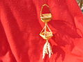 Barton Turf has given its name to a traditional Corn dolly which consists of two vertical baskets.
 -
 Some paintings from the 15th-century Rood Screen in St Michael and All Angels church, Barton Turf
 -
 Thrones (angels) from the 15th-century Rood Screen in St Michael and All Angels church, Barton Turf
 -
 Cherubim from the 15th-century Rood Screen in St Michael and All Angels church, Barton Turf
 -
 Iconoclastic damage from the Reformation, St Michael and All Angels church, Barton Turf


References edit
- ^ Ordnance Survey (2005). OS Explorer Map OL40 - The Broads. ISBN 0-319-23769-9.
- ^ Office for National Statistics & Norfolk County Council (2001). Census population and household counts for unparished urban areas and all parishes. Retrieved 2 December 2005.
- ^ "Civil Population 2011". Archived from the original on 29 July 2014. Retrieved 2 September 2015.
- ^ Rye, Walter (1895). . In Lee, Sidney (ed.). Dictionary of National Biography. Vol. 41. London: Smith, Elder & Co. pp. 115–116.
- ^ a b c d e Historic England. "Barton Hall (1170539)". National Heritage List for England. Retrieved 6 December 2019.
External links edit
- High resolution images of the Barton Turf Rood Screen
- Information from Genuki Norfolk on Barton Turf
- Barton [Turf] in the Domesday Book
- http://kepn.nottingham.ac.uk/map/place/Norfolk/Barton%20Turf