


Summary
The Bartonsville Covered Bridge is a wooden covered bridge in the village of Bartonsville, in Rockingham, Vermont, United States. The bridge is a lattice truss style with a 151-foot span, carrying Lower Bartonsville Road over the Williams River. It was built in 2012, replacing a similar bridge built in 1870 by Sanford Granger. The 1870 bridge, which was listed on the National Register of Historic Places, was destroyed in 2011 in flooding caused by Hurricane Irene.
Bartonsville Covered Bridge | |
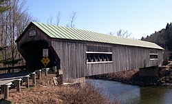 The Northeast approach to the Bartonsville bridge, March 28, 2006 prior to its destruction | |
  | |
| Location | Bartonsville, Vermont |
|---|---|
| Coordinates | 43°13′27.23″N 72°32′12.45″W / 43.2242306°N 72.5367917°W |
| Area | 1 acre (0.40 ha) |
| Built | 1871 |
| Architect | Granger, Sanford |
| NRHP reference No. | 73000201[1] |
| Added to NRHP | July 2, 1973 |

History edit
The bridge was built after the great flood of 1869 that changed the course of the river, replacing another covered bridge about 1/4 mile up the road where the river used to flow.[2] The bridge is listed on the National Register of Historic Places.
It was located on Lower Bartonsville Road, a paved road a short distance north from Vermont Route 103. Nearby, to the east, is the Worrall Covered Bridge, also built by Granger.
In the 1960s, a Town of Rockingham gravel truck fell through the bridge cutting off cars from Lower Bartonsville Village from the direct link to Vermont Route 103 until the floor was replaced. In the early 1980s extensive renovations were conducted on the bridge, including replacing the abutment on the north side of the bridge, reinforcing the original stone abutments on the south side of the bridge, and replacing the roof and the weathered siding.
Destruction by Hurricane Irene and replacement edit
On August 28, 2011, the bridge was destroyed by flash flooding caused by excessive rainfall from Hurricane Irene's landfall on the U.S. East Coast.[3][4][5] An effort to rebuild the structure[6] was supported by town officials, who voted to use the bridge's insurance money to build another covered bridge.[7]
The new bridge was opened on January 26, 2013.[8]
See also edit
- National Register of Historic Places listings in Windham County, Vermont
- List of bridges on the National Register of Historic Places in Vermont
- List of Vermont covered bridges
- Old Blenheim Bridge, a covered bridge in upstate New York, also destroyed by Tropical Storm Irene; rebuilt in 2017
References edit
- ^ "National Register Information System". National Register of Historic Places. National Park Service. July 9, 2010.
- ^ Lovell, F.S. & Lovell, L.C. (1958). History of the Town of Rockingham, Vermont: Including the Villages of Bellows Falls, Saxtons River, Rockingham, Cambridgeport and Bartonsville, 1907 – 1957 with Family Genealogies. Town of Rockingham.
- ^ Flooding takes toll on historic bridges Archived March 24, 2012, at the Wayback Machine, WCAX.com
- ^ Kane, Trish. "Video clips and news on covered bridge damage due to Hurricane Irene". Vermont Covered Bridges Society website. Retrieved August 31, 2011.
- ^ Eckholm, Erik (August 31, 2011). "Covered Bridges, Beloved Remnants of Another Era, Were Casualties, Too". The New York Times. Retrieved September 1, 2011.
- ^ Bartonsville woman who caught bridge’s destruction, now helps to rebuild it[permanent dead link], Rutland Herald
- ^ Keese, Susan (November 2, 2011). "Bartonsville Bridge To Be Rebuilt". vpr.et. Vermont Public Radio. Retrieved November 22, 2011.
- ^ Melissa Sheketoff, WCAX-TV, Historic Bridge Back Open Archived January 30, 2013, at the Wayback Machine, January 26, 2013