


Summary
In geology and geomorphology a base level is the lower limit for an erosion process.[1] The modern term was introduced by John Wesley Powell in 1875.[1] The term was subsequently appropriated by William Morris Davis who used it in his cycle of erosion theory.[1][2] The "ultimate base level" is the surface that results from projection of the sea level under landmasses.[1] It is to this base level that topography tends to approach due to erosion, eventually forming a peneplain close to the end of a cycle of erosion.[3][4][5][6]
There are also lesser structural base levels where erosion is delayed by resistant rocks.[1] Examples of this include karst regions underlain by insoluble rock.[7] Base levels may be local when large landmasses are far from the sea or disconnected from it, as in the case of endorheic basins.[1] An example of this is the Messinian salinity crisis, in which the Mediterranean Sea dried up making the base level drop more than 1000 m below sea level.[8][9]
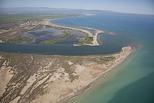
The height of a base level also influences the position of deltas and river terraces.[1] Together with river discharge and sediment flux the position of the base level influences the gradient, width and bed conditions in rivers.[10] A relative drop in base level can trigger re-adjustments in river profiles including knickpoint migration and abandonment of terraces leaving them "hanging".[11] Base level fall is also known to result in progradation of deltas and river sediment at lakes or sea.[12] If the base level falls below the continental shelf, rivers may form a plain of braided rivers until headward erosion penetrates enough inland from the shelfbreak.[12]
When base levels are stable or rising rivers may aggrade.[12] Rising base levels may also drown the lower courses of rivers creating rias. This happened in the Nile during the Zanclean flood when its lower course became, in a relatively short time, a large estuary extending up to 900 km inland from the Mediterranean coast.[9]
Base level change may be related to the following factors:
- Sea level change[1]
- Tectonic movement[1]
- River capture[1]
- Extensive sedimentation[13]
References edit
- ^ a b c d e f g h i j Goudie, A.S. (2004). "Base level". In Goudie, A.S. (ed.). Encyclopedia of Geomorphology. Routledge. p. 62.
- ^ Orme, Anthony R. (2007). "The Rise and Fall of the Davisian Cycle of Erosion: Prelude, Fugue, Coda, and Sequel". Physical Geography. 28 (6): 474–506. Bibcode:2007PhGeo..28..474O. doi:10.2747/0272-3646.28.6.474. S2CID 128907423.
- ^ Phillips, Jonathan D. (2002), "Erosion, isostatic response, and the missing peneplains", Geomorphology, Vol. 45, No. 3-4. Elsevier Archived 2010-01-24 at the Wayback Machine, 15 June 2002, pp. 225-241. doi:10.1016/S0169-555X(01)00156-8.
- ^ Chorley, R.J. (1973). The History and Study of Landforms or The Development of Geomorphology. Vol. Two: The Life and Work of William Morris Davis, Methuen.
- ^ Green, Paul F.; Lidmar-Bergström, Karna; Japsen, Peter; Bonow, Johan M.; Chalmers, James A. (2013). "Stratigraphic landscape analysis, thermochronology and the episodic development of elevated, passive continental margins". Geological Survey of Denmark and Greenland Bulletin. 30: 18. doi:10.34194/geusb.v30.4673.
- ^ Lidmar-Bergström, Karna; Bonow, Johan M.; Japsen, Peter (2013). "Stratigraphic Landscape Analysis and geomorphological paradigms: Scandinavia as an example of Phanerozoic uplift and subsidence". Global and Planetary Change. 100: 153–171. Bibcode:2013GPC...100..153L. doi:10.1016/j.gloplacha.2012.10.015.
- ^ Ford, Derek C. (2004). "Cave". In Goudie, A.S. (ed.). Encyclopedia of Geomorphology. Routledge. pp. 124–128.
- ^ Fairbridge, Rhodes W.; Finkl Jr., Charles W. (1980). "Cratonic erosion unconformities and peneplains". The Journal of Geology. 88 (1): 69–86. Bibcode:1980JG.....88...69F. doi:10.1086/628474. S2CID 129231129.
- ^ a b Goudie, A.S. (2005). "The drainage of Africa since the Cretaceous". Geomorphology. 67 (3–4): 437–456. Bibcode:2005Geomo..67..437G. doi:10.1016/j.geomorph.2004.11.008.
- ^ Whipple, Kelin X. (2004). "Bedrock channel". In Goudie, A.S. (ed.). Encyclopedia of Geomorphology. Routledge. pp. 81–82.
- ^ Spotila, James A. (2004). "Crustal deformation". In Goudie, A.S. (ed.). Encyclopedia of Geomorphology. Routledge. pp. 201–203.
- ^ a b c Koss, John E.; Ethridge, Frank G.; Schumm, S.A. (1994). "An Experimental Study of the Effects of Base-Level Change on Fluvial, Coastal Plain and Shelf Systems". Journal of Sedimentary Research. 64B (2): 90–98. doi:10.1306/D4267F64-2B26-11D7-8648000102C1865D.
- ^ Babault, Julien; Van Den Driessche, Jean; Bonnet, Stephanie; Castelltort, Sébastien; Crave, Alain (2005). "Origin of the highly elevated Pyrenean peneplain". Tectonics. 24 (2): n/a. Bibcode:2005Tecto..24.2010B. doi:10.1029/2004TC001697.